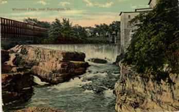
The postcard above was printed in Germany for the Metropolitan News Company of Boston, Massachusetts.
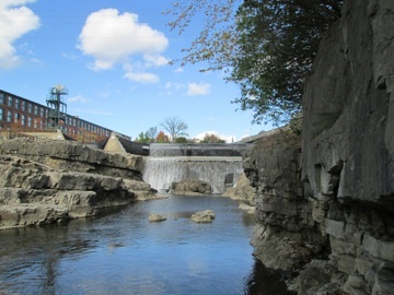
The photo above was taken from a northwesterly direction from the rocks of the lower falls on the Winooski River on October 11th, 2012.
The postcard above has a disfigured and ripped back.
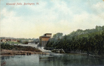
The photo on the right was taken from a northeasterly direction across the Winooski River on October 11th, 2012.
WINOOSKI FALLS
These postcards are images of Winooski Falls, both from around the turn of the century. The landscape of Winooski Falls has changed a great deal over the past 100 plus years, and these postcards may represent some of the most drastic change over time in the Burlington area. The following will focus on five main structures in these postcards those being the woolen mill building, the bridge connecting Winooski and Burlington, the river dam, and the various dwellings on both the east and west sides of the bridge.
THE MILL BUILDING - At the time of the photograph, the prominent mill building in the bottom left postcard was called the Colchester Merino Mill. This was the main factory for the Burlington Woolen Mills Company located in the part of Colchester that is now called Winooski.[1] The history of industrial mill buildings and power dams at Winooski Falls is certainly a long one. As far back as 1837, there was a Colchester Mills mentioned in the Burlington Free Press.[2] Jumping forward to 1844 a sawmill burned in Colchester at what was then referred to as Winooski City. According to an article in the Burlington Free Press, the mill that burned in 1847 contained planning machines of Messrs. Smith on the second floor, which were also destroyed in the fire.[3]
In 1850, the Burlington Free Press reported the sale of the real estate of a "Woolen mill building" on the Colchester side of the Winooski River. The mill was fully stocked with 16 sets of cards, and according to the Burlington Free Press it was one of the best examples in all of New England.[4] This is the first confirmable mention of the mill building in our photo, and this idea is strengthened by an article from the next year that described the "brick building" for auction including all of the equipment in it such as weaving looms, dressers, furnaces, laves and etc.[5]
On the first Sanborn Fire Insurance map of this area, produced in 1884, the mill building in our photo was labeled the Colchester Merino Mill, and at that time it was three story brick building surrounded by windows much like the one we see today. The first floor was used for a storeroom, the second for carding, and the third was for spinning. In 1884, the building was heated with steam and lit with a combination of gas and electric power.[6]
In between 1889 and 1894, the picker room, which is not visible in these photos but is significant the building none-the-less, had doubled in size,[7] and by 1899 it is clear that the mill was too small for the production it was outputting. At this time spinning was now carried out on the both first and second floors, and carding and dressing both occurred on the third floor.[8] Also in 1899, the mill property was sold at auction to H. G. Nicholas of Boston Mass, but the papers made small mention of this sale and claimed "there will be little change for employees."[9]
Between 1899 and 1904, the Colchester Merino Mill building changed its official name designation, and was from then on referred to as mill #3. A much larger complex of buildings could be found behind this building at this time, and also small pump station with a 6" water pipe, built in front of building, was most likely in the view of one of these postcards.[10] The biggest change however came between 1904 and 1909, when the Burlington Woolen Mill company built a huge addition to the building, presumably to accommodate production. This addition easily doubling mill #3 in size, and extended its length to span over the canal that had formerly run past the end of the building to the south.[11]
The mill building would continue to be occupied by mill companies for the next fifty years, and at some point in between 1926 and 1942 the building went under renovation refitting the interior with modern wood studs and plastered walls.[12]
In 1956, the woolen company, now renamed Champlain Woolen Mills, finally left the old mill building behind, and it was vacant for one year until,[13] the Forest Hills Factory Outlet took over full-time operation on this lot.[14] In 1969, the Forest Hills Factory Outlet, seems to have been a modest, but perhaps struggling, shopping outlet with a snack bar and cafeteria, a Coin-Op Laundry-Mat, a jewelry store, a hard goods distributor, a shoe story, a toy store, a country store, a do-it-yourself store, as well as seven vacant storefronts.[15] These outlets seem to have had a relatively high turn over rate because just six years later, in 1975, only a few of these stores remained including the Coin-Op Laundromat, the Jewelry store (but under a different name), the National Hard Goods Distributors, the shoe store, and the country store. A few new shops had opened those being the Forest Hills Beauty Salon, a camera depot, and storage space, but vacant lots also remained available in the Forest Hills Factory Outlets.[16]
By 1981, the factory outlets had closed down and in that year the Forest Hills Housing Project began construction.[17] Today, the "Woolen Mill" apartments are 800 to 1700 square foot housing units ranging from studio sized to two bedroom living spaces. There are a few different variations of apartment but generally they all encompass two to three bays of the factory building, and are one or two floors each. Those living in this housing complex, which claims to be "Vermont's most unique apartments" enjoy amenities including a health club, an indoor heated pool, and racquetball courts.[18]
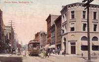
THE BRIDGE - The bridge connecting Winooski (which was part of Colchester at this time) and Burlington is also a major part of this photo that has undergone a good deal of change over the years. In 1884 there was a wooden bridge connecting Winooski city and Burlington.[19] However, that bridge was replaced between 1884 and 1889 with an iron structure.[20] The iron bridge is the one seen in the background of the postcard on the top left of the page. This bridge would connect the two cities until 1928, when the Winooski-Burlington highway bridge replaced the old iron structure destroyed by the flood of 1927.[21]
POWER DAMS - The hydroelectric dam we see at Winooski Falls in the modern day is not the only damn to ever use at the falls. The site at Winooski Falls has reportedly been used as a dam since "just after the Revolutionary War,"[22] and by 1850 the Colchester Mill building was using power from the river.[23] In the 1980s John Warshow and Matthew Rubin proposed hydroelectric dam project at Winooski Falls, and permitting was made somewhat easier because of the historic presence of other mill damns on the falls. Never-the-less this was a difficult project to see through and Warshow and Rubin had many troubles acquiring permits with the State of Vermont, the Army Corps of Engineers, Federal Energy Regulatory Commission, and the Vermont Historic Preservation Commission. Projects to protect spawning fish and endangered plants and a riverside park were both developed along side the dam project as compromises to various interests in Winooski. In 1991 the construction of the Winooski One Hydroelectric Power Dam began and by 1993 the dam was to generating power.[24]
DWELLINGS ON THE EAST SIDE OF THE WINOOSKI BRIDGE - include the addresses for 5,7,9,10 Main Street, and in the easterly looking photo these two wooden dwellings are apparent just to the east side of the bridge and Main Street in Winooski city. In 1899 the dwellings on the right first appeared on the map with ruins on the right side of an older brick building.[25] By 1904 the dwelling on the left first appeared and was named "the Brunswick house."[26] Those buildings stood roughly unchanged but sometime before 1919 the American Woolen Mills building or "Champlain Mills" a building similar in mass to the Colchester Merino Mills building first appeared on the map.[27] In 1978, 5,7,9, and 10 Main Street all appeared on the last Sanborn map, and perhaps these buildings were taken as part of the development of the riverfront park project developed along side the Winooski One Hydroelectric Power Dam, because today these buildings do not exist and are part of the riverfront park in Winooski.[28] The dominant building in the modern day easterly looking photograph is the old Champlain Mill building (also once known as the American Woolen Mill Building), which has been re-purposed for office space and retail.[29]
DWELLINGS ON THE WEST SIDE OF THE WINOOSKI BRIDGE - In the easterly looking photo two wooden and one brick buildings are apparent on the west side of the bridge. There was a great deal of change to this entire lot throughout the late 19th and early 20th century but this particular massing seems to first appear between 1899 and 1904.[30] By 1942 the three buildings seem to have been built right up to one another as urban lots as various apartments above and storefront facing Main Street.[31] Today these buildings on this urban lot still exist, and the brick building is currently home to "Donny's New York Pizza" at 22 Main Street.
6. Sanborn Fire Insurance Map for Winooski, Vermont, 1884.
7. Sanborn Fire Insurance Map for Winooski, Vermont, 1894.
8. Sanborn Fire Insurance Map for Winooski, Vermont, 1899.
9. "Mills Sold at Auction," Burlington Weekly Free Press, March 2, 1899. http://chroniclingamerica.loc.gov/lccn/sn86072143/1899-03-02/ed-1/seq-8/
10. Sanborn Fire Insurance Map for Winooski, Vermont, 1904.
11. Sanborn Fire Insurance Map for Winooski, Vermont, 1909.
12. Sanborn Fire Insurance Map for Burlington (and Winooski), Vermont, 1942.
13. Burlington Winooski South Burlington and Essex Junction Vermont Directory for 1956 (Springfield Mass: H.A. Manning Company, 1956), 688.
14. Manning's Burlington Winooski South Burlington and Essex Junction Vermont Directory for 1958 (Springfield Mass: H.A. Manning Company, 1958), 682 .
15. Manning's Burlington South Burlington Winooski and Essex Junction (Chittenden County, Vermont) Directory 1969 (Greenfield Mass: H.A. Manning Company, 1969), 753.
16. Manning's Burlington and, South Burlington Winooski and Essex Junction Chittenden County, Vermont Directory 1975-76 (Greenfield Mass: H.A. Manning Company, 1976), 478.
17. Manning's Burlington and South Burlington Essex Junction and Winooski Directory 1981 (Bellows Falls, VT: H.A. Manning Co., 1981), 474.
18. The Woolen Mill: Our Amenities, http://www.woolen-mill.com/amenities.html; The Woolen Mill: Living Spaces, http://www.woolen-mill.com/living-spaces.html
19. Sanborn Co., Sanborn Fire Insurance Map for Winooski, Vermont, 1884.
20. Sanborn Co., Sanborn Fire Insurance Map for Winooski, Vermont, 1889.
21. David E. Robinson and Mary Ann DiSpirito, Images of America: Burlington (Charleston, SC: Arcadia Publishing, 1997), 42.
22. Greg Pahl, The Citizen-Powered Energy Handbook: Community Solutions to A Global Crisis (White River Junction, VT: Chelsea Green Publishing Company, 2007), 107-8.
23. "Marshall's Sale," Burlington Weekly Free Press, November 14, 1851, from Chronicling America: America's Historic Newspapers 1836 – 1922.
24. Pahl, 107-8.
25. Sanborn Co., Sanborn Fire Insurance Map for Winooski, Vermont, 1889.
26. Sanborn Co., Sanborn Fire Insurance Map for Winooski, Vermont, 1904.
27. Sanborn Fire Insurance Map for Winooski, Vermont, 1919.
28. Sanborn Fire Insurance Map for Burlington (and Winooski), Vermont 1978.
29. "A Champlain Mill for the 21st Century" http://www.thechamplainmill.com
30. Sanborn Fire Insurance Map for Winooski 1899; Sanborn Fire Insurance Map for Winooski, 1904.
31. Sanborn Fire Insurance Map for Burlington, and Winooski, 1942.