View of Camel’s Hump from Burlington, postcard, The Hugh C. Leighton Co., Manufacturers, Portland, ME, U.S.A. Printed in Frankfurt o/Main Germany No. 3269, post date April 13, 1912.
Camel’s Hump from the tower of Old Mill, photo by Jessica Goerold, 2012.
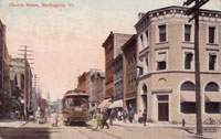
This 1912 postcard shows a large expanse of green space, Converse Hall, the buildings of the University of Vermont's State Experimental Farm/Agricultural Experiment Station and the Green Mountains in the background. Mostly farmland lies between UVM and the mountains. The Vermont Agricultural Experimental Station was purchased using funds granted by the Hatch Act of 1886. This act promised an annual grant of $15,000 to each state for the purpose of establishing experimental farm stations.(1) It was and still is an important part of the educational curriculum of the State College of Agriculture.
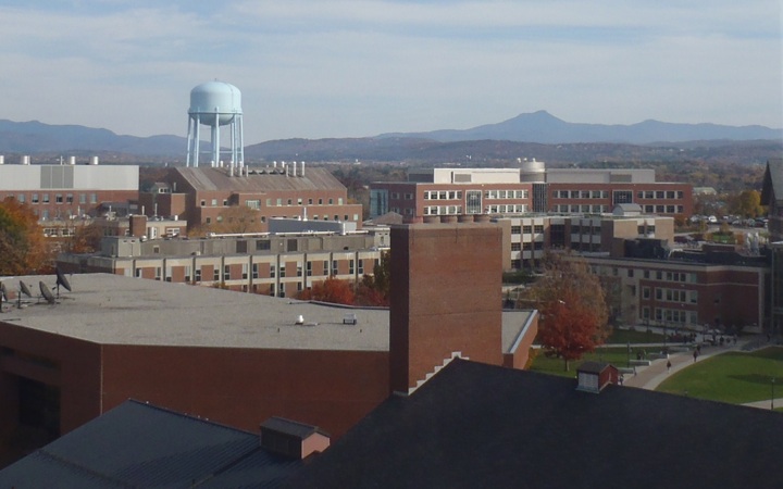
The current photo shows much change. The University has expanded greatly. In effect, the only buildings one can readily identify are owned by either UVM or Fletcher Allen Health Care. In the foreground, one can see the roof of Royall Tyler Theatre (originally the university's gymnasium, built in 1901 and currently home to the Drama Department). Just behind the theatre is the Bailey-Howe Library. The Davis Center is just to the right of the photo, separated from the library by a small green with wide cement paths. In the middle ground, there is a large cluster of medical and science buildings. These include the Medical Education Center (home to the Dana Medical Library and the Health Science Research Facility), Rowell Hall, the Marsh Life Science building, the Aiken Center (home to the Rubenstein School of Environment and Natural Resources), as well as a large greenhouse. The background is dominated by the Green Mountains.
The mountains remain largely the same. The most distinctive visible feature is the Camel's Hump, which has had a few different names over the years. French explorers in the 1600s reputedly called it "lion couchant", meaning "resting lion". In 1798 Ira Allen referred to it as Camel's Rump on a map and the name stuck, eventually making the official change to Camel's Hump in 1830.(2)
Camel's Hump State Park is made up of 18,153 acres of land with some camping areas and many hiking trails open to the public, some of which can be reached from the Long Trail.(3) At 4,083 feet, the Camel's Hump is the 4th highest mountain in Vermont.(4) Its 10-acre summit is an exceptional research area and contains a wide variety of unique plant specimens. Below 2,500 feet the forest is maintained and managed for multiple uses and above that same altitude it's been preserved in its natural state.(5)
(1) Cheryl Ann Dorschner, "UVM Farms' has History of Changing Places," published October 11, 2010, http://www.uvm.edu/cals/?Page=News&storyID=17121.
(2) "Vermont State Parks-Camel's Hump State Park", updated 2009, accessed November 13, 2012, http://www.vtstateparks.com/htm/camelshump.htm.
(3) Charles W. Johnson, The Nature of Vermont (Hanover: UPNE, 1998), 260.
(4) Elizabeth H. Thompson and Eric R. Sorenson, Wetland, Woodland, Wildland: A Guide to the Natural Communities of Vermont (Hanover: University Press of New England, 2005), 37.
(5) Johnson, 260.