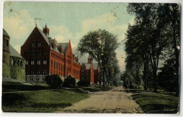
This postcard of University Place was dated circa 1900-1923. The image was taken from across Billings Library looking south down University Place. To the left of the postcard is Billings Library, Williams Science Center, and Old Mill.
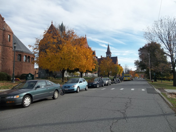
This photo was taken from across Billings Library looking south down University Place. Billings Library, Williams Science Center, and Old Mill are located to the left of the image and down University Place.
Based on the two pictures above, the University Place has remained the same with only some changes. The buildings visible in both photos from left to right include: Billings Library, Williams Science Hall, and Old Mill. The changes of these buildings include changes to their uses, but there have also been changes in the landscape surrounding University Place.
In 1894, the College Green was described as having two groves, one of pine and the other of tamaracks. Chauncey Goodrich reportedly planted the pine grove in the 1850's and Professor Farrand W planted the tamaracks. Benedict. There was also supposedly a group of cedars planted by President Wheeler and elms surrounded the College Green.(1) In the University Place postcard circa 1900-1923, there is a visible row of trees along the right side of University Place. These trees most likely were the elms that surrounded the Campus Green.
During the 1930s and 40s Dutch elm disease started to spread throughout America from infected elm logs imported from Europe. In 1949, the threat of the Dutch elm disease in Vermont was severe enough for the Governor at the time, Ernest W. Gibson, to discuss it in his inaugural speech. Gibson said about the disease, "…left unchecked there is every reason to expect this to spread rapidly and damage our trees. I believe provision should be made for inspections by out department of Agriculture to determine the spread of this disease and that steps be taken to encourage community effort in carrying out clean up and control measures."(2) Efforts were made throughout the state to save the elms but it had no effect and most of the elms, especially on campus, were felled during the 1960s and 70s.(3)
It is also obvious from the two views of University Place that the roadway has also changed significantly. Originally the road would have been made just of dirt and used by horse-drawn vehicles. With the introduction of the motorized vehicle the streets were altered to accommodate automobiles. Those renovations would have included, laying down pavement and even making the roadways wider because the increasing car size. So the transportation changes that were occurring nationwide can be seen occurring at University Place during the 20th century through the photographs taken.
Early Sanborn insurance maps show that University Place has changed to make way for the construction of Billings Library, Williams Science Hall, and Old Mill. The original college building was constructed in 1800; it was made of brick and was four stories high. It had a chapel, seven public rooms, and 45 rooms for students. It burned in 1824 though, but through a quick response from students, faculty and the Burlington community, a new college building was erected almost immediately.(4) The three separate buildings that were connected and expanded to create the Old Mill known today, can be seen on the 1830 Burlington City Map. The map shows three unconnected buildings in the spot where Old Mill stands today.(5) The construction of North and South Colleges occurred in 1825; the Marquise de La Fayette even laid the cornerstone for the South College Building, while Governor Cornelius Van Ness laid the cornerstone for the North College.(7) Then around 1829 the Middle College Building was constructed; John Johnson designed all three buildings. The maps available from 1830 until 1942 continue to show Old Mill unchanged, except for its name.
What the maps do not show is the evidence that Old Mill was rebuilt and reconstructed during 1882 to 1883. John P. Howard, who also donated funds for the fountain, La Fayette statue, and the Medical College building, funded the rebuilding. The construction of Old Mill resulted in an increased height, wall projections on either end, the chapel was extended, windows and doors added, and the dome (located on the Middle College) was replaced with a belfry and spire.(8) Early in its history, Old Mill was used for dorms and a drill hall, and then it was the Main Building, then Old College, and eventually renamed Old Mill.(9)
The Williams Science Center appears first on the 1894 Sanborn insurance map. Originally the University had planned for the science center to be located just north of the President's home, but construction of the electric car road on Colchester Avenue made it impossible.(10) Before Williams Science Center was constructed, the University's Museum was located there (in between Billings Library and Old Mill).(11) The Old Museum of Natural History that Williams' replaced was moved to its current location and is known today as Torrey Hall. Dr. Edward H. Williams and his wife donated the funds for Williams Science Center; Dr. Williams worked for the Baldwin Locomotive Works of Philadelphia. The Wilson Brothers & Co. architectural and engineering firm from Philadelphia designed the Williams Science Center.(12)
Lastly, Billings Library replaced the home used by the University of Vermont's President Marsh. This home was different than the other President's House, which was known as the "Yellow House," while President Marsh's home was known as the "White House." After Marsh used the home, the building was used as a boarding house for students.(13) The "White House" was demolished to make way for Billings Library in 1885, when construction for Billings began. Though the "White House" can be seen on the 1869 Map of Burlington; by 1885 Billings Library is present on the Sanborn insurance maps. (14) So even though the tow views of University Place do not show any obvious changes to the buildings exteriors, their constructions changed the layout of the University Place.
Text by Courtney Doyle
1. Joseph Auld, Picturesque Burlington: A Handbook of Burlington, Vermont and Lake Champlain (Burlington: Free Press Association, 1893), 116.
2. Ernest W. Gibson, Inaugural Address, Journal of the Joint Assembly, Biennial Session, 1949. State of Vermont Archives, http://www.vermont-archives.org/govhistory. Defenders of Wildlife, Invasive Species in Vermont, http://www.defenders.org/publications/vermont.pdf.
3. University of Vermont Trees, "UVM Tree History," PowerPoint presentation, located at www.uvm.edu/~uvmtrees/?Page=meet/treetour.html&SM=meet/submeet.html, accessed December 1, 2012.
4. E.F. Walbridge, "Historical Sketch of the University," Ariel 1917, (Burlington, VT: University of Vermont: Junior Class, ed.), 1917, 418-438.
5. A. B. Youn, Map of Burlington, Vermont (New York: Lith. Of Pedletor), 1830.
6. E.F. Walbridge, "Historical Sketch of the University," Ariel 1917, (Burlington, VT: University of Vermont: Junior Class, ed.), 1917, 418-438.
7. Thomas Visser and Mary Jo Llewellyn, Historic Structures Report: Old Mill, UVM Historic Preservation, ACES, 1988, 1-2.
8. E.F. Walbridge, "Historical Sketch of the University," Ariel 1917, (Burlington, VT: University of Vermont: Junior Class, ed.), 1917, 418-438.
9. Sanborn Insurance Map, Burlington Vermont, June 1912, New York: Sanborn Map & Publishing Co., 1912, Sheet 36. Sanborn Insurance Map, Burlington Vermon,t June 1900, New York: Sanborn Map & Publishing Co., 1900, Sheet 30. Sanborn Insurance Map, Burlington Vermont, June 1885, New York: Sanborn Map & Publishing Co., 1885, Sheet 15.
10. E.F. Walbridge, "Historical Sketch of the University," Ariel 1917, (Burlington, VT: University of Vermont: Junior Class, ed.), 1917, 418-438.
11. Sanborn Insurance Map, Burlington Vermont, June 1894, New York: Sanborn Map & Publishing Co., 1894, Sheet 25. Sanborn Insurance Map, Burlington Vermont, June 1885, New York: Sanborn Map & Publishing Co., 1885, Sheet 15.
12. Jenna Lapachinski, University Green Area Heritage Study: Williams Hall, UVM Historic Preservation, 2011, http://www.uvm.edu/~hp206/2011/sites/8.html. Jeffery D. Marshall, Universitas Vinidis Montis, 1791-1991: An Exhibition of Documents and Artifacts Telling the Story of the University of Vermont, (Burlington, Vt: University of Vermont, 1991), 62.
13. Junior Class ed., Ariel, Vol. 18, (Burlington, Vt: University of Vermont), University Archives, University of Vermont, 1905.
14. Sanborn Insurance Map, Burlington Vermont, June 1885, New York: Sanborn Map & Publishing Co., 1885, Sheet 15. Sanborn Insurance Map, Burlington Vermont, June 1869, New York: Sanborn Map & Publishing Co 1869, Sheet 13.