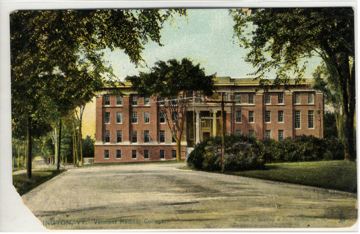
This postcard of Dewey Hall, dated circa 1900-1923 shows Dewey Hall and to the west of Dewey can be seen the Vilas family house. This image would have been taken looking northwest at Dewey, which is very close to the intersection of University Place and Colchester Avenue.
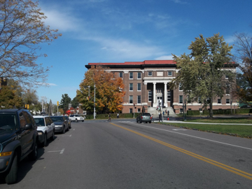
This photo of Dewey Hall was taken at the corner of University Place and Colchester Avenue, looking northwest at Dewey Hall. Besides Dewey Hall, the area to the west of Dewey, which is visible in this photograph shows the edge of the Lambda Iota Fraternity house. Photo taken by author, 2012.
This postcard, dated circa 1900-1923 shows Dewey Hall and the building located to the east of Dewey, which is known today as 12 Colchester Avenue or Pearl House. This image would have been taken near the intersection of today's Pearl Street and South Prospect Avenue looking northeast.
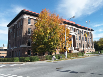
This image shows not only Dewey Hall, but also the corner of the Red Cross building located north of Dewey Hall. The fall foliage hides the location of 12 Colchester, which would be located west of Dewey Hall ( to the right of Dewey in this photo). Photo taken by author, 2012.
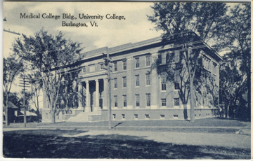
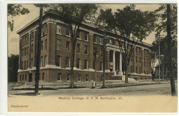
This postcard was postmarked 1911 and shows Dewey Hall. The image would have been taken from South Prospect Street looking north at Dewey Hall.
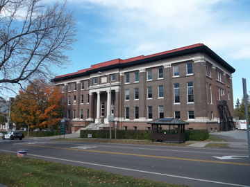
This image of Dewey Hall also was taken on South Prospect Street, looking north at Dewey. The image also shows the Red Cross building behind Dewey (north of Dewey Hall) and the Outing Club building, located east of Dewey Hall. In this photograph, the Outing Club building is to the right of Dewey Hall and is a dark green with yellow triming. Photo taken by author, 2012.
The first set of postcards shows Dewey Hall and a building to the west of Dewey Hall. Dewey Hall was constructed between 1904 and 1905 and became the new Medical College building.(1) The building to the west of Dewey Hall is known today as the Lambda Iota Fraternity House. That plot of land has not always been the home of the Lambda Iota Fraternity though. On the 1853 Burlington city map, the lot is shown with a rectangular building that has an ell on the northwest side of the building. The lot also shows a number of other buildings ranging in size and shape (mostly square and rectangular).(2) On the 1862 Burlington Sanborn insurance map the same lot is labeled with the name W. R. Vilas; this name appears again on the 1869 Burlington map, the only difference was the name, W. H. Vilas (these two men are the same person).(3)
The 1885 Sanborn insurance map shows the lot without any names and shows only two buildings. One of the buildings is roughly a square with a rectangular addition (horizontal) to the back and attached to that addition are two smaller vertical rectangular additions. To the northwest of this building is a wooden structure, which is a shed with two wooden attachments that expand to the east.(4) Then, on the 1890 Hopkins map, the lot is labeled with the name Mary N. Vilas and there are no changes to the lot or the buildings. The Vilas Homestead remained on this lot until 1906, at which time the homestead was sold by Mrs. Vilas to Elihu B. Taft for $6,800. At that time there were no plans on what to do with the homestead but it was known the site would become the home of the University of Vermont's Lambda Iota Fraternity.(5)
Then in 1912 it was reported that ground had been broken for the new Lambda Iota Chapter House. The plans for the building included a colonial style house that was to cost $25,000 and the architects behind the building were Newhall & Bevins of Boston, Massachusetts.(6) The 1912 Sanborn insurance map, shows that the Vilas home has been removed and that construction for the fraternity home has already been started; the building was labeled "Chapter House,".(7) This building has remained the Lambda Iota House and throughout the years has gone through numerous interior and exterior renovations. Some of those repairs have included: fire alarm systems, plumbing, replacement of old windows, replacement of slate, and bathroom repairs.(8)
The second postcard view shows two different buildings along with Dewey Hall. In the postcard the building seen to the east of Dewey is 12 Colchester, while in the new picture the Red Cross Building can be seen and 12 Colchester is blocked from view by foliage.
The area that the Red Cross is located on today can be identified on the 1853 Burlington map, as being owned by H. Bradley.(9) In 1862 the land was then owned by Levi Underwood. Then in 1869, Underwood was not the only person in the area. Behind his lot to the north were two other lots: the south lot was labeled W.E. Gooker and the north lot was labeled N. Sterns.(10) On the 1890 Hopkins map those lot areas are labeled with the names of D.S. Morse and Mrs. M. F. Kelly.(11) Starting in 1885 the Underwood lot had become the property of the University of Vermont (it had become the Medical College) and the lots behind the Medical College seem to have been vacant of any buildings and persons.(12) It is possible though that the area just was not displayed on any of the Sanborn Insurance Maps of this time. This remains the case until at least 1942, where the Sanborn insurance map still did not show any structure in the area of the current Red Cross.(13) Then in 1976, the current Red Cross building was constructed and has remained a medical facility the entire time.(14)
The other two buildings that are visible in the old postcards and the current views of Dewey Hall are, 8 Colchester Avenue and 12 Colchester Avenue. 8 Colchester is currently the home of the University of Vermont's Outing Club, whose history goes back to 1936 when the club appeared in the University's yearbook, the Ariel.(15) Though it has been difficult to find 8 Colchester in the directories because of the changes in street numbering, it has been possible to find the building on the Sanborn insurance maps. While the Burlington Assessor's Office dates the building to 1900 and other sources suggest the structure first appears in 1906, there was a building located between the Medical College and today's 12 Colchester Avenue that can be found on the 1885 Burlington city map.(16) The structure that is shown is small and rectangular and can be found on the Burlington maps from 1885 onwards During that time the small structure has been labeled as a hen house, shed, and even as a lab in 1942.(17) The Outing Club moved into the building in 1976 and has remained there ever since.(18)
The history of 12 Colchester Avenue is apparently a long one, having been built in 1798.(19) The building was present in 1862 as it can be seen on the Burlington city map and is labeled as the A. Foote Estate.(20) Then in 1869, the land and the building became the property of O.S. Wood.(21) The building continued to remain on the Sanborn insurance maps unlabeled after 1869. The 1890 Hopkins map labeled the structure as the G.M. Peterson home.(22) The building remained unlabeled until the 1912 Sanborn Insurance Map, which labeled the structure as the "Lyman Hall Building."(23) Then, in 1942, the building was being used for office space.(24)
Though the access to the history of 12 Colchester Avenue at the University of Vermont's Special Collections is sparse, there are other means to research the building. David Blow's Historic Guide to Burlington Neighborhoods, gives a brief history of the building; he writes that 12 Colchester was built in 1789 by Frederick Saxton and then sold to Colonel Stephen Pearl shortly after.(25) Colonel Pearl was an American Revolutionary War veteran and he was one of the first settlers in Burlington; he died in 1816.(26) Blow continues the building's history by saying that in 1856 Alvan Foote owned the building, followed in 1869 by O.S.Wood, and then Luther C. Dodge owned the building for some time. In 1872 the building was sold to John H. French and then in 1919 the building was sold to the University. The building was remodeled in the 1980's to be a daycare. There have also been other types of renovations done to the building since then too, including: electrical, plumbing, fire systems, bathroom renovations, and renovations to create office space.(27) Currently the building houses the University of Vermont's Office of Student and Community Relations.(28)
Text by Courtney Doyle
1. Untitled, St. Albans Daily Messenger, April 3, 1905. "To Build Medical College," St. Albans Daily Messenger, August 18, 1904. More information on Dewey Hall can be found under the Medical College research page by Courtney Doyle.
2. Presdee & Edwards, Map of Burlington Vermont, 1853, UVM Special Collections.
3. Sanborn Insurance Map, Burlington Vermont June 1862, New York: Sanborn Map & Publishing Co., Sheet 10. Sanborn Insurance Map, Burlington Vermont June 1869, New York: Sanborn Map & Publishing Co., Sheet 13.
4. Sanborn Insurance Map, Burlington Vermont June 1885, New York: Sanborn Map & Publishing Co., Sheet 15.
5. Untitled, Argus and Patriot, November 21, 1906.
6. "Ground Broken for New Lambda Iota House," St. Albans Daily Messenger, August 15, 1912.
7. Sanborn Insurance Map, Burlington Vermont June 1912, New York: Sanborn Map & Publishing Co., Sheet 30.
8. City of Burlington Assessor's Office, Permit History: 440 Pearl Street, reported as of: 11/13/2012. http://gis.ci.burlington.vt.us/GeneratedReports/1114201240441AM75.pdf.
9. Presdee & Edwards, Map of Burlington Vermont, 1853, UVM Special Collections.
10. Sanborn Insurance Map, Burlington Vermont June 1869, New York: Sanborn Map & Publishing Co., Sheet 13.
11. G.M. Hopkins, Map of the City of Burlington Vermont from Official Records, Private Plans, and Actual Surveys, Philadelphia: Hopkins, 1890.
12. Sanborn Insurance Map, Burlington Vermont June 1885, New York: Sanborn Map & Publishing Co., 1885, Sheet 9.
13. Sanborn Insurance Map, Burlington Vermont June 1942, New York: Sanborn Map & Publishing Co., 1942, Sheet 29.
14. City of Burlington Assessor's Office, Permit History: 32 North Prospect Ave., reported as of: 11/13/2012. http://gis.ci.burlington.vt.us/GeneratedReports/1114201241141AM97.pdf
15. George Smith, ed., Ariel, Vol. 49, University Archives, University of Vermont, 1936.
16. City of Burlington Assessor's Office, Permit History: 8 Colchester Ave., reported as of: 11/13/2012. http://www.burlingtonvt.gov/PropertyDetails.aspx?a=6356. Robyn Sedgwick, University Green Area Heritage Study: 8 Colchester Ave., UVM Historic Preservation Graduation Program, 2011, http://www.uvm.edu/~hp206/2011/sites/58a.html. Sanborn Insurance Map, Burlington Vermont June 1885, New York: Sanborn Map & Publishing Co., 1885, Sheet 9.
17. Sanborn Insurance Map, Burlington Vermont June 1942, New York: Sanborn Map & Publishing Co., 1942, Sheet 29. Sanborn Insurance Map, Burlington Vermont June 1885, New York: Sanborn Map & Publishing Co., 1885, Sheet 9. Sanborn Insurance Map, Burlington Vermont June 1900, New York: Sanborn Map & Publishing Co., 1900, Sheet 30.
18. Robyn Sedgwick, University Green Area Heritage Study: 8 Colchester Ave., UVM Historic Preservation Graduation Program, 2011, http://www.uvm.edu/~hp206/2011/sites/58a.html.
19. Robyn Sedgwick, University Green Area Heritage Study: 12 Colchester Ave., UVM Historic Preservation Graduation Program, 2011, http://www.uvm.edu/~hp206/2011/sites/58.html.
20. Sanborn Insurance Map, Burlington Vermont June 1862, New York: Sanborn Map & Publishing Co., 1862, Sheet 13.
21. Sanborn Insurance Map, Burlington Vermont June 1869, New York: Sanborn Map & Publishing Co., 1869, Sheet 15.
22. G.M. Hopkins, Map of the City of Burlington Vermont from Official Records, Private Plans, and Actual Surveys, Philadelphia: Hopkins, 1890.
23. Sanborn Insurance Map, Burlington Vermont June 1912, New York: Sanborn Map & Publishing Co., 1912, Sheet 33.
24. Sanborn Insurance Map, Burlington Vermont June 1942, New York: Sanborn Map & Publishing Co., 1942, Sheet 32.
25. David Blow, Historic Guide to Burlington Neighborhoods, Burlington, Vt: Chittenden County Historical Society, 1991, pg. 62-63.
26. "Colonel Pearl's Obituary," National Standard, November 21, 1816.
27. David Blow, Historic Guide to Burlington Neighborhoods, Burlington, Vt: Chittenden County Historical Society, 1991, pg. 62-63. City of Burlington Assessor's Office, Permit History: 12 Colchester Ave., reported as of: 11/13/2012. http://gis.ci.burlington.vt.us/GeneratedReports/1114201295939AM57.pdf.
28. Robyn Sedgwick, University Green Area Heritage Study: 12 Colchester Ave., UVM Historic Preservation Graduation Program, 2011, http://www.uvm.edu/~hp206/2011/sites/58.html.