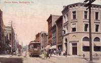
A postcard view of lower King Street, seen from the Champlain Transportation Company’s steamboat wharf, facing east, circa 1919. It was a complex working waterfront of lumber yards and mills, warehouses, manufacturers, railroad tracks, steamboats, and boathouses. (Courtesy of Special Collections, Bailey/Howe Library, University of Vermont)
The King Street Steamboat Wharf in Changing Times
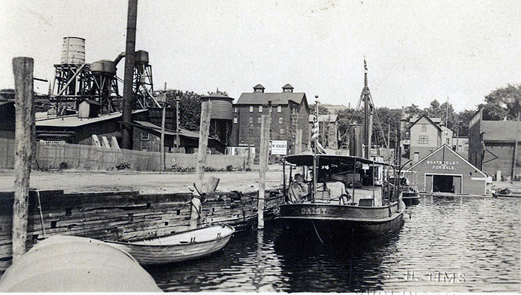
The early twentieth century black and white photo for this King Street dock postcard was taken from a boat next to the dock, facing east up lower King Street, across Battery Street, to downtown Burlington, Vermont. Behind the photographer was the west end of the dock, the Champlain Transportation Company's steamboat wharf. Vertical (“walking”) beam, sidewheel steamboats, some of them hundreds of feet long, were berthed there. But in this view, a small steamboat called Daisy is the central element in the scene, made fast to the dock, in shallower water. Behind Daisy is a tender or rowboat. Beyond these boats, closer to the shore, another small steamboat is partly visible. (1)
Near the corner where the shore meets the dock is a boathouse, at water level, with a sign saying, “BOATS TO LET. AND FOR SALE.” Just barely visible behind the boathouse on the right is one end of a much smaller boathouse. A frame grocery warehouse is beyond these buildings on the right. (2)
In the background, a three-story, frame, storage building (3) with two cupolas stands at the northwest corner of King and Battery streets. Between the viewer and that building is a sign that seems to say, “W. RIGHT.” Directly behind the boathouse is a 2 1/2-story, frame building, the offices of the Champlain Transportation Company, with its gable ends facing west to the lake and east to Battery Street. (4) On the city's skyline is the top floor of the Hotel Vermont, built at the corner of Main and St. Paul streets in 1911. Industrial structures belonging to the Shepard and Morse Lumber Company, on the north side of the King Street dock, are the other prominent element in the picture, on the left. (5) (6)
When the 1885 Sanborn map of Burlington was drawn, the Champlain Transportation Company had already operated at this dock at the end of King Street for many years, and the southern end of the Shepard and Morse Lumber Company was next to it. (7) In other ways, though, the scene pictured in the postcard is completely different from what it had been in the late nineteenth century. This is typical of the waterfront, which was a continually changing patchwork of land uses, especially this section of it. Comparing the postcard's scene to all the Sanborn maps from 1885 to 1919, it is clear that the landscape pictured is closest to the 1919 map. (8)
Another clue to the photo's date is the American flag at the stern of the steamboat Daisy. The flag has 48 stars, so the photo could not have been taken before July 4, 1912, when that flag replaced the 1908 version with 46 stars. (9)
The postcard is embossed, “F. H. TIMS, BURLINGTON, VT.” on the front. The back of the card does not say where it was printed. The Real Photo Postcards “A Z O” pattern is where the stamp belongs, with the triangles pointing up in the upper corners and down in the lower corners, (10) indicating that the card was probably made after 1917. (11)
The huge Shepard and Morse Lumber Company extended from north of College Street, along the waterfront, south to the King Street steamboat wharf. Adjacent to this dock and the lake were stacks of lumber. These piles could be as high as 12 feet, and there were so many of them that they had numbered paths or “streets” between them. (12)
First Street was parallel to the steamboat wharf at the southern end of the Shepard and Morse yard. Between the stacked lumber near the steamboat wharf and the railroad tracks east of it was a long, rectangular, frame building, a one-story planing mill. (13) The southern gable end of this mill can be seen in the photo, on the far left.
On the east side of the planing mill was a finishing mill. The photo shows the southern end of this building, where the engine, shavings vault, and shavings press were. East of that, hidden from view, was a lumber shed, “not sprinklered.” (14)
This scene is south of the 1916 Union Station. Several railroad tracks that passed by the station also crossed the foot of King Street, forming an intersection that cannot be seen in the photo. On the far side of the track, towering over the lumber mills and shed, is a circular railroad water tank. (15) The streetcar route was about a block away to the south, with a spur to the west end of Maple Street. (16)
The 1919 Sanborn map describes the building near the water on the far right as a “track ware house.” The building was owned by the Burlington Grocery Company, and was also labeled on the map, “James E. Cashman, Storage Ware House.” (17) It first appeared on the Sanborn maps in 1894. (18) It was a two-story, frame building, which had been damaged by fire (or destroyed and replaced) in April 1900, along with the Spaulding, Kimball and Company grocery warehouse that was next door, to the south.
The 1900 fire started in a Rutland Railroad horse barn, which had formerly belonged to yet another neighbor, the Elias Lyman Coal Company, to the south. The fire affected railroad cars next to the grocery warehouses, and all three structures, which were close together. By 1919 the only one of the three still standing was the Burlington Grocery Company warehouse. The Burlington Weekly Free Press said that a December 1898 conflagration, which had destroyed mills and lumber yards of the Shepard and Morse Lumber Company, had started in the same horse barn. (19)
The Champlain Transportation Company's office at the southwest corner of Battery and King streets had been a paint shop in 1894. (20) In 1900 it was an awnings store. (21) The 1906 Sanborn map shows it belonging to “J. Wakefield, manufacturer of awnings and tents.” (22)
James Wakefield advertised in the 1906 Burlington city directory, “Rigger and Sailmaker, Manufacturer of Awnings, Tents, Wagon Covers And Canopy for Weddings and Parties To Let. Also Buntings, Flags of all kinds, Tarred and Manila Cordage, Galvanized Wire Rope, Tackle Blocks, Boat Oars, Row-locks, Life Preservers, Life Buoys and Swimming Jackets, Anchors and Folding Anchors, Navy Lanterns, Side Lights, Yacht Fenders, Steering Wheels, Tar, Pitch, Oakum, and all kinds of Yacht Fixtures.” (23) A similar ad in the Free Press the following year had the heading, “Awnings! Awnings! Awnings!” (24)
Wakefield employed his son John as a sailmaker. James Wakefield Jr. was listed in the 1906 city directory as the lighthouse keeper for Split Rock. (25)
The elder Wakefield had been the breakwater lighthouse keeper from 1872 to 1890. (26) He and one of his sons risked their lives to rescue the passengers and captain of a canal schooner, the General Butler, when the schooner was wrecked on the Burlington breakwater in a December 1876 gale, with the temperature below zero. (27) (28)
His business grew beyond Burlington and Vermont, and Wakefield was interviewed by a reporter from the Burlington Weekly Free Press in 1909. Born in Cambridgeshire, England in 1829, he remembered the coronation of Queen Victoria in 1838. He went to sea as an apprentice at the age of 13, became a mate on a clipper ship, and a sailor in the British Navy, traveled the world, learned to make rigging and sails, and eventually settled in Whitehall, New York. He moved to Burlington in 1857, started his ship's chandlery, was the janitor of St. Pauls' Church, and had 12 children. (29) (30)
He retired in 1911 because of illness, (31) and his sons John, Albert, Fred, and George took over. (32) They moved the awning, tent, wagon cover, and ship's chandlery business to a sail loft at 52 College Street. James Sr. died of cancer on June 22 of that year, at the age of 82. (33) (34) (35)
The Champlain Transportation Company's office expanded up the hill to the Wakefields' former location, but the steamboat company still retained an office at the end of the dock. (36) (37) (38) Local contractors submitted bids on the work of remodeling the building on the company's dock, and the new office for the general manager and clerical staff of both the Champlain and Lake George steamboat companies. The former ship's chandlery would be “fitted up in good shape with a hot water heating plant, new floors, windows, doors, office furniture and toilet rooms.” The office on the wharf would have running water and lavatories, the waiting room would be enlarged, and the freight and ticket offices would gain some space from what had been the general offices. (39)
Decades later, the company was still using Wakefield's former building as an office. (40) (41) “James Wakefield Sons” was still advertising “awnings, tents, etc.” at 112 North Avenue in 1946. (42)
Shelburne Shipyard in Shelburne, Vermont built ever bigger - as well as more elegant and powerful - sidewheel steamers for the transportation company. They sailed the length and breadth of the lake. Meanwhile small, propeller-driven steamboats similar to the ones in this postcard navigated narrow, shallow waterways and crossed the lake in the late nineteenth and early twentieth centuries. For example, the Daniels Steamboat Line operated diminutive steamers out of Vergennes, Vermont on Otter Creek to Port Henry and Westport, New York from 1877 to 1916, carrying freight and passengers. These vessels would meet larger steamboats, such as the Vermont from Burlington, on the New York shore, before the larger boat's trip south to Ticonderoga. When the Vermont returned, the smaller craft would pick up passengers for the trip across the lake to Vergennes. The Daniels' steamers also towed canal boats. (43) (44)
The matriarch of the family was Philomene Ostiguy dit Domingue Daniels, born in Quebec. She became the first female licensed steamboat pilot in the United States in 1887, after passing the licensing exam at the U. S. Coast Guard station on the Burlington waterfront. (45) (46) (47)
When this postcard photo was taken, steamer Daisy was crammed with boxes and other containers. It is not possible to tell whether she was being used as a houseboat or a freight carrier, or both.
During the late nineteenth and early twentieth centuries, the Burlington waterfront was lined with frame boathouses. On Sanborn maps, many boathouses were described as floating, but the two in the photo were not. Some offered boats to rent, and were labeled liveries. Henry Chiott owned a boathouse by the dock at least as far back as 1902. (48) He was the keeper of the breakwater lighthouse from 1893 to 1907. His son Edgar served as keeper from 1907 to 1933. (49) Besides being a base of operations for Henry's and Edgar's lighthouse work, the boathouse was a money-making venture. In 1920, Edgar Chiott's boathouse was listed in the city directory as a “boat and skating house.” (50)
He began advertising his boat livery in the directory; by 1925 he had purchased a small, illustrated display ad to appeal to recreational boaters who wanted to rent canoes or rowboats. (51)
North of the steamboat company's office, on the northwest corner of King and Battery streets, the three-to-four-story building with the cupolas was used for storage. The 1919 map does not specify what was stored in the building. (52) This site too had been transformed many times. The 1885 and 1889 Sanborn maps showed a different footprint; two smaller buildings occupied the spot, and both were dwellings. Two more small dwellings were in a narrow building behind them, along with a large stack of lumber. A row of sheds was next to them to the north. (53) (54)
By 1894, the north end of the dwelling closest to Battery Street was gone, as well as the sheds and the lumber stack (55). In 1900, no building stood at the northwest corner of King and Battery streets. (56) The 1906 map shows another entirely different footprint. The nearly square, frame, three-story building was a “beer ware house” on the first floor, and vacant above. The north side of the building was a vacant store. The whole west wall was iron clad. Piles of Shepard and Morse lumber partly surrounded the building on two sides. Across Battery Street to the east were “dwellings and small stores.” (57)
On the 1912 Sanborn map, this frame building is labeled a bottling works and beer warehouse. The upper floors were still vacant. A lumber shed was attached to the iron clad wall on the west, and was “not sprinklered.” The shed extended from the west wall of the bottling works to the railroad track. The north wall of the bottling works was also iron clad, with lumber piles adjacent. (58)
By 1919, the Sanborn map said this three-to-four-story storage building, former beer warehouse, was vacant. (59) City directories in the late 1910s described it as vacant or did not list it. (60) It was no longer close to piles of lumber.
On the southeast corner of Battery and King streets, faintly visible in the background in the postcard, is a three-story brick grocery store with an awning on the first floor. (61) On the northeast corner is a vacant store. (62)
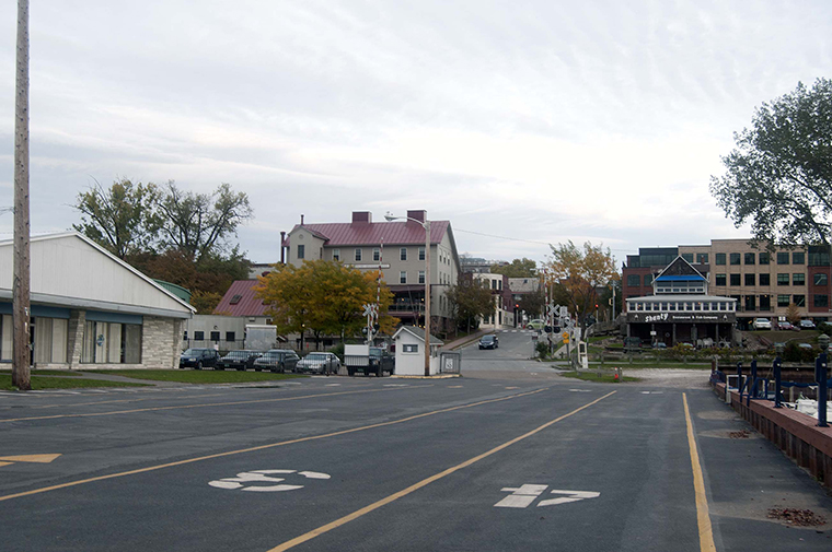
In October 2012 the scene from the foot of King Street still contained a few remnants from circa 1919. (Figure 2) The Champlain Transportation Company's steamboat wharf had become part of the Lake Champlain Transportation Company in 1948. (63) From this wharf, ferries now depart to and arrive from Port Kent, New York.
The wharf is much wider than it was. The 2012 photo shows several numbered lanes for vehicles to line up waiting for the ferry, after passing the small white ticket booth. The yellow line between lane number 3 and the exit lane is approximately where the southern edge of the wharf used to be. The boat houses no longer exist.
On the left, in place of the jumble of lumber mills and elevated cisterns on stilts is a building with a shallow-pitched roof that houses the offices of the Vermont Lake Monsters minor league baseball team and Lake Champlain Cruises, which operates the 115-foot cruise boat Northern Lights. The former storage building and beer warehouse at the northwest corner of King and Battery streets is now the Ice House Restaurant and Bar, and a beauty salon. The building has been extended to the north and there is an addition on the southeast corner. The tops of the cupolas are gone.
The former Champlain Transportation Company office building (and, before that, paint store and then awning store and ships' chandlery) is now the Shanty Restaurant and Fish Company. There is a dirt parking lot where the Burlington Grocery Company warehouse used to be. In 1919 a platform projected south from the warehouse parallel to a railroad spur that ended at the warehouse. The foundation of the platform remains. (64)
Barbara R. Bosworth
The same place and view, October 13, 2012. Now the scene, looking east, includes the Lake Champlain Transportation Company ferry dock and ticket booth, the Lake Champlain Cruises and the Vermont Lake Monsters minor league baseball team headquarters on the left, the Ice House Restaurant and Bar in the middle distance, and the Shanty Restaurant and Fish Company to the right of it. (Photo by Barbara R. Bosworth)
Endnotes
(1) Postcard, Burlington Harbor, Burlington Postcard Files, Special Collections, University of Vermont Bailey/Howe Library.
(2) Ibid.
(3) Sanborn Map Company, “Burlington, Chittenden County, Vermont” (New York: Sanborn Map Company, 1919), map 22.
(4) Sanborn Map Company, “Burlington, Chittenden County, Vermont” (New York: Sanborn Map Company, 1919), map 23.
(5) Sanborn Map Company, “Burlington, Chittenden County, Vermont” (New York: Sanborn Map Company, 1919), map 22.
(6) Postcard, Burlington Harbor, Burlington Postcard Files, Special Collections, University of Vermont Bailey/Howe Library.
(7) Sanborn Map and Publishing Company, “Burlington, Vermont” (New York: Sanborn Map and Publishing Company, 1885), map 11.
(8) Sanborn Map Company, “Burlington, Chittenden County, Vermont” (New York: Sanborn Map Publishing Company, 1919), maps 22 and 23.
(9) “Historical Flags,” Embassy of the United States of America, Stockholm, Sweden, November 2001,
http://web.archive.org/web/20080225142325/http://stockholm.usembassy.gov/usflag/flaghist.html (accessed October 2012).
(10) Postcard, Burlington Harbor, Burlington Postcard Files, Special Collections, University of Vermont Bailey/Howe Library.
(11) Thomas D. Visser, class lecture, HP 206 Researching Historic Structures and Sites, University of Vermont, September 12, 2012.
(12) Sanborn Map Company, “Burlington, Chittenden County, Vermont” (New York: Sanborn Map Company, 1919), map 22.
(13) Ibid.
(14) Ibid.
(15) Sanborn Map Company, “Burlington, Chittenden County, Vermont” (New York: Sanborn Map Company, 1919), map 22.
(16) “The City of Burlington and Village of Winooski,” map enclosed in the 1911 Burlington City and Winooski Directory (Burlington, Vermont: L.P Waite & Co., 1911).
(17) Sanborn Map Company, “Burlington, Chittenden County, Vermont” (New York: Sanborn Map Company, 1919), map 23.
(18) Sanborn-Perris Map Company, “Burlington, Chittenden County, Vermont” (New York: Sanborn-Perris Map Company, 1894), map 20.
(19) “Grocery Houses Burned, Storehouses of Spaulding, Kimball & Co. and Burlington Grocery Co. Destroyed – Loss About $50,000,” Burlington Weekly Free Press, April 19, 1900, 8.
(20) Sanborn-Perris Map Company, “Burlington, Chittenden County, Vermont” (New York: Sanborn-Perris Map Company, 1894), map 20.
(21) Sanborn-Perris Map Company, “Burlington, Chittenden County, Vermont” (New York: Sanborn-Perris Map Company, 1900), map 24.
(22) Sanborn Map Company, “Burlington, Chittenden County, Vermont” (New York: Sanborn Map Company, 1906), map 25.
(23) L. P. Waite and Company, Burlington, Vermont City Directory (Burlington, Vermont: L. P. Waite and Company 1906), 268.
(24) James Wakefield advertisement, Burlington Weekly Free Press, July 11, 1907, 12.
(25) L. P. Waite and Company, Burlington, Vermont City Directory (Burlington, Vermont: L. P. Waite and Company, 1906), 268.
(26) “Burlington Breakwater Lights History,” updated January 10, 2011, http://lighthouse.cc/burlingtonbreakwater/history.html (accessed October 2012 ).
(27) “Shipwrecks: Sailing Canal Boat General Butler,” Lake Champlain Maritime Museum, http://www.lcmm.org/shipwrecks_history/uhp/general_butler.htm (accessed October 2012).
(28) “James Wakefield's Interesting Experiences of Sixty Years Ago,” Burlington Weekly Free Press, December 16, 1909, 9.
(29) Ibid.
(30) James Wakefield obituary, Burlington Weekly Free Press, June 27, 2012, 5.
(31) Ibid.
(32) L. P. Waite and Company, Burlington, Vermont City Directory (Burlington, Vermont: L. P. Waite and Company, 1912), 265.
(33) Ibid.
(34) James Wakefield death certificate, June 22, 1912, Vermont Death Records, 1909-2008, Vermont State Archives and Records Administration, Montpelier, Vermont.
(35) James Wakefield obituary.
(36) Sanborn Map Company, “Burlington, Chittenden County, Vermont” (New York: Sanborn Map Company, 1912), map 28.
(37) Sanborn Map Company, “Burlington, Chittenden County, Vermont” (New York: Sanborn Map Company, 1919), map 23.
(38) Sanborn Map Company, “Burlington, Chittenden County, Vermont” (New York: Sanborn Map Company, 1926), map 21.
(39) “C.T.Co.'s Offices, Changes to be Made as Soon as Contract is Awarded,” Burlington Weekly Free Press, May 25, 1911, 5.
(40) Sanborn Map Company, “Burlington, Chittenden County, Vermont” (New York: Sanborn Map Company, 1926), map 21.
(42) H. A. Manning and Company, Burlington, Vermont City Directory (Springfield, Massachusetts: H. A. Manning and Company 1946), 320.
(43) “Photographs of Vergennes (Vt.),” Center for Digital Initiatives, University of Vermont Libraries,
http://cdi.uvm.edu/collections/index.xql (accessed October 2012).
(44) “Vergennes, VT – The Vergennes Shipyard, Historic Landings Heritage Trail,” Wayside Exhibits, Lake Champlain Basin Program, http://www.lcbp.org/wayside/sites/historiclandings.htm (accessed October 2012).
(45) Ibid.
(46) “Did You Know,” Educators' Newsletter, Lake Champlain Maritime Museum, November 3, 2005,
http://www.lcmm.org/education/educators_newsletters/educators_news_05_11.html (accessed October 2012).
(47) The Otter Creek Basin Student History Club, “Philomene Daniels: World's First Female Steamship Captain,” Vermont Historical Society Community History Project, 2003, http://www.vermonthistory.org/chp/pages/projects/vergennes/index.html (accessed October 2012).
(48) L. P. Waite and Company, Burlington, Vermont City Directory (Burlington, Vermont: L. P. Waite and Company, 1902), 85.
(49) “Burlington Breakwater Lights History,” updated January 10, 2011, http://lighthouse.cc/burlingtonbreakwater/history.html (accessed October 2012 ).
(50) H. A. Manning and Company, Burlington, Vermont City Directory (Springfield, Massachusetts: H. A. Manning and Company, 1920), 439.
(51) H. A. Manning and Company, Burlington, Vermont City Directory (Springfield, Massachusetts: H. A. Manning, 1925), 539.
(52) Sanborn Map Company, “Burlington, Chittenden County, Vermont” (New York: Sanborn Map Company, 1919), map 22.
(53) Sanborn Map and Publishing Company, “Burlington, Vermont” (New York: Sanborn Map and Publishing Company, 1885), map 11.
(54) Sanborn Map and Publishing Company, “Burlington, Vermont” (New York: Sanborn Map and Publishing Company, 1889), map 11.
(55) Sanborn-Perris Map Company, “Burlington, Chittenden County, Vermont” (New York: Sanborn-Perris Map Company, 1894), map 20.
(56) Sanborn-Perris Map Company, “Burlington, Chittenden County, Vermont” (New York: Sanborn-Perris Map Company, 1900), map 19.
(57) Sanborn Map Company, “Burlington, Chittenden County, Vermont” (New York: Sanborn Map
Company, 1906), map 20.
(58) Sanborn Map Company, “Burlington, Chittenden County, Vermont” (New York: Sanborn Map
Company, 1912), map 27.
(59) Sanborn Map Company, “Burlington, Chittenden County, Vermont” (New York: Sanborn Map Company, 1919), map 27.
(60) H. A. Manning and Company, Burlington, Vermont City Directory (Springfield, Massachusetts: H.A. Manning, 1916-1920).
(61) Sanborn Map Company, “Burlington, Chittenden County, Vermont” (New York: Sanborn Map Company, 1919), map 23.
(62) Sanborn Map Company, “Burlington, Chittenden County, Vermont” (New York: Sanborn Map Company, 1919), map 14.
(63) John Ross, Arthur B. Cohn, and J. Kevin Graffagnino, The Steamboats of Lake Champlain, 1809 to 1930 (s.l.: Vermont Heritage Press, 1930, 1997), 195.
(64) “7 Maple Street, Burlington, Vermont,” 44 degrees 28' 25.05” N, 73 degrees 13' 09.36” W, elevation: 104 feet, Google Earth 6.1.0.5001, Imagery date: May 15, 2012 (accessed September 2012).