
|
 |
 |
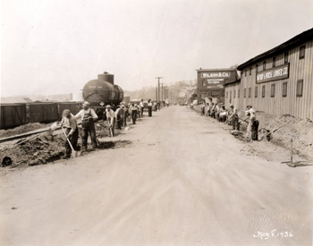
Lake Street In 1936, Lake Street was at the center of Burlington’s industrial waterfront. Oriented north-south, the street roughly paralleled the shore of Lake Champlain and provided access to several warehouses, lumberyards, and manufacturing businesses along the waterfront. Two McAllister photographs show an open streetscape with limited buildings and vegetation. Railroad tracks line the west edge of Lake Street, as evidenced by a tanker car and boxcars in the left foreground. In Photo3, two groups of men line the west and east sides of the street, respectively. The west group of men is digging individual holes that are evenly spaced with standard shovels. To the east, the men are digging a narrow trench for new underground utilities. A string line has been set up using wood posts to outline the exact position and width of the trench. A few overhead utility lines are seen in the background of the image, and vegetation is limited. Photo 4 shows a similar view of Lake Street at this time. The image also provides additional information about the street work being done. The front of the image reads, “Lake Street. A view of the project looking north along its length from the intersection of College Street and Lake Street.” The photograph also has a more detailed caption on the back stating, “Lake Street WPA Project No. 65-12-336 looking north from intersection of College Street. This project consists of widening pavement to twenty-four feet with Telford Stone base construction, surfacing with a leveling course of penetration macadam varying in thickness from one to four inches and constructing Hot Mix stone filled sheet asphalt wearing surface two inches in thickness.” Both photographs depict two buildings located along the east side of Lake Street. In the foreground is a large two-story, seven bay rectangular building with vertical board and batten siding, with a smaller one story, four bay addition to the north. Windows on both the main block and addition are relatively small and evenly spaced. A sign reading “Shepard & Morse Lumber Co.” is centered between the first and second stories on the main block. The building was likely constructed between 1869 and 1877, as a long, rectangular building with similar features appears on the 1877 bird’s eye view of Burlington(1). Interestingly, the property on which the building is sited has been an operating lumberyard since 1869, then owned by H.B. Stucy(2). By 1901, Shepard & Morse Lumber Company occupied the site, and continued to run the lumberyard throughout the 1930s(3). The building is the largest of a complex of buildings on the property. North of the Shepard & Morse Lumber Company building is a three story, three bay frame building with brick veneer. “Wilson & Co, Certified” is painted in white on the center of the exterior façade. The large rectangular first floor windows appear to contain large multi-paned glass, while the second story has two recessed arches flanking the white letters of the sign. The building contains refrigeration machinery; Wilson & Company was a meat wholesaler(4). Since the building not numbered with a street address, tracking the building history is difficult. The brick veneer building likely dates to the late 19th century, as it does not appear on the 1869 Beers Map or the 1877 Bird’s Eye of Burlington(5). By 1901, four refrigerating companies occupied buildings in the vicinity of the Wilson & Company building including the Northern Provision Company, the Baldwin Refrigerator Co., the Monarch Refrigerator Works, and Eclipse Refrigerator Works(6). By 1931, Wilson & Company occupied the building, and continued to do so throughout the early 1940s(7). Back to Depression Era Streetscapes.
(1) Bird’s Eye View. Burlington, Vermont 1877. (2) Beers Map of Burlington Vermont. 1869. (3) Burlington City Directory, 1931, 1942 (Burlington: H. A. Manning Co., 1916-1986). (4) Sanborn-Perris Map. Burlington, Vermont 1942; Burlington City Directory, 1931, (Burlington: H. A. Manning Co., 1916-1986). (5) Beers Map of Burlington Vermont. 1869; Bird’s Eye View. Burlington, Vermont 1877. (6) Burlington City Directory, 1901, 1942 (Burlington: H. A. Manning Co., 1916-1986). (7) Burlington City Directory, 1931, 1942 (Burlington: H. A. Manning Co., 1916-1986). |
86 Lake Street The view looking north down Lake Street today hardly recalls Burlington’s early industrial working-class waterfront of earlier decades. As industry and manufacturing declined throughout the mid 20th century, the buildings along Lake Street and the waterfront gradually fell into disrepair. The unsightly buildings and overall rundown state of the area, created an opportunity to revitalize the waterfront. During the 1980s, efforts were made to clean up the former industrial waterfront area through zoning regulations, recreation initiatives, and a revitalization plan(1). In 1988, the Burlington bike path was constructed, creating a north-south recreational corridor through the waterfront area and linking the city of Burlington to adjacent towns(2). Efforts to improve the area continued into the 1990s. Today the waterfront area attracts many visitors and residents through the several amenities and recreational opportunities it provides. As a result of these revitalization efforts, the streetscape of Lake Street has changed significantly. The street allows for two-lane traffic and on-site, metered parking to the east. Concrete curbs and gutters, and allees of young maple trees define the street edges. A low concrete wall with deciduous shrub plantings helps to further define the space to the west, while a six-foot sidewalk parallels the street to the east (right). The Shepard & Morse Lumber Company building was torn down prior to 1942 and the lot remained vacant through 1972(3). During the early 2000s, 60 Lake Street was constructed at the intersection of Lake Street and College Street. The building commonly called “Lake and College” houses several tenants including the Waterfront Theatre and organizations and businesses such as Vermont Businesses for Social Responsibility and Merritt & Merritt & Moulton, lawyers. Through the tree canopy, the partial façade of the Wilson & Company building at 86 Lake Street can be seen. The exterior of the building remains virtually unchanged, still exhibiting three bays with large rectangular, multi-paned windows on the first floor with recessed arches that have been converted into windows on the second floor. The large white letters that once adorned the exterior façade have been removed. Today, the building is occupied by Otter Creek Associates and Gentlemen's Top Option Salon. Back to Depression Era Streetscapes.
(1) Community Economic Development Office, City of Burlington, Vermont; Waterfront. www.cedoburlington.org/ 9 November 2006. (2) Community Economic Development Office, City of Burlington, Vermont; Waterfront. www.cedoburlington.org/ 9 November 2006. (3) Burlington City Directory, 1942, 1972 (Burlington: H. A. Manning Co., 1916-1986). |
Historic Burlington Project Depression Era Streetscapes: Old North End | Burlington 1890 | Burlington 1877 | Burlington 1869 | Burlington 1853 | Burlington 1830 Produced by University of Vermont Historic Preservation Program graduate students in HP 206 Researching Historic Structures and Sites - Prof. Thomas Visser - in collaboration with UVM Landscape Change Program Historic images courtesy of University of Vermont Library Special Collections, Louis L. McAllister Photograph Collection |