
 |
 |
284-290 Manhattan Drive, Photo by Louis McAllister in 1929 Coordinates: 18T 0642047 UTM 4927580
This photo is the first of three in a series showing the construction of low-cost pavement on North Bend at the corner of Spring Street. It was described in the 1930 Burlington Annual Report, “This picture shows the method used in constructing a “Mixed-in Place” Asphalt Pavement, using river gravel and Special No. 6 Standard Asphalt for binder material and mixing in place by the use of the farm spring-tooth and disc harrows hauled by Fordson Caterpillar Tractor.”[1] Note the man on the rear tractor smiling for the camera. In the rest of the photo, houses, utility poles, and trees spread in to the distance until North Bend rounds the corner, after it crosses Oak Street. On the left side of the street, 284 and 290 Manhattan Drive can clearly be seen. 284 North Bend is a small brick house that traces back through the city directories to 1901 when Mrs. Louisa Dion, a widow, was living there with her daughter Mary.[2] The 1919 Sanborn does not list an address for this one and a half story brick home, but does show a small barn at the back of the property.[3] The house changed from its old address of 280, to its current one of 284 in 1923.[4] The McAllister image is not dated, but other work on this section of North Bend was done in 1929. At this time the house is still brick with stepped parapets that feature double chimneys on each side. The 1926 Sanborn map shows that the barn in back had been replaced with a small auto garage.[5] Constructed around 1890, 290 North Bendwas a two-story side gabled house with decorative front gables in the center of the house. Attached to the front, there was an enclosed porch that ran the entire length of the house. In 1897 Joseph Shequin, a city carter, moved in along with his parents.[6] The 1929 McAllister photo shows some additions. A bay window was added to the North side, and the house added onto the back.1. Sixty-Sixth Annual Report of the City of Burlington, Vermont (Burlington: Free Press Printing, 1930), 221. 2. Burlington City Directory Including Winooski & South Burlington (Burlington: L.P. Waite & Co., 1901). 3. Sanborn Map, 1919. Special Collections, University of Vermont, Burlington, Vermont. 4. Burlington and Winooski, Vermont Directory (Springfield, Mass: H.A. Manning Co., 1914 through 1938). 5. Sanborn Map, 1926. Special Collections, University of Vermont, Burlington, Vermont. 6. Burlington City Directory Including Winooski & South Burlington (Burlington: L.P. Waite & Co., 1897). |
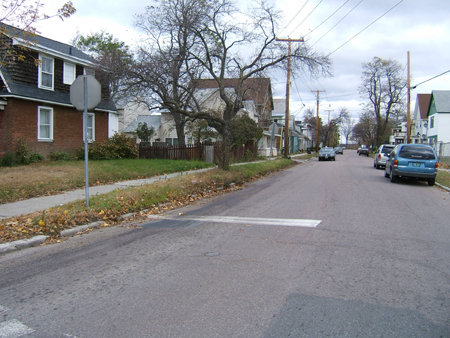
284-290 Manhattan Drive, Photo by Julie Weisgerber in 2005
Today, 284 Manhattan Drive is almost unrecognizable today. The 1942 Sanborn shows that the house more then doubled in size.[7] The house retained the brick exterior on the first floor, but the parapets were replaced by a steep gambrel roof with pop outs to give the structure 2 full stories. Attached to the back, a one-story addition was added. All of the new walls were covered in shingles. Today, the main part of the house is 284, and the one story attached unit is a separate apartment. 290 Manhattan Drive still looks very similar today. It has been covered in siding, and the sun porch changed slightly. The other changed is the row of (4) attached apartments tucked behind the main building. One thing that remarkably has remained is the large tree that sits outside of 290 Manhattan Drive. 7. Sanborn Map, 1926. Special Collections, University of Vermont, Burlington, Vermont.
|
Return to Manhattan Drive Index
Historic Burlington Project Burlington 1890 | Burlington 1877 | Burlington 1869 | Burlington 1853 | Burlington 1830 Produced by University of Vermont Historic Preservation Program graduate students in HP 206 Researching Historic Structures and Sites - Prof. Thomas Visser in collaboration with UVM Landscape Change Program Historic images courtesy of Louis L. McAllister Photograph Collection University of Vermont Library Special Collections |