 |
 |
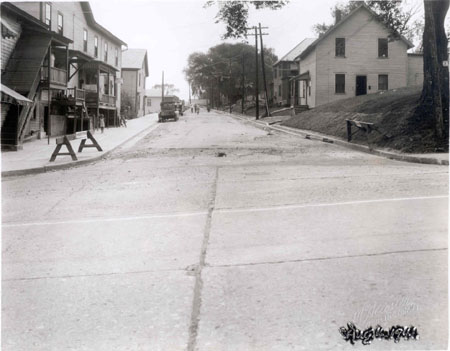
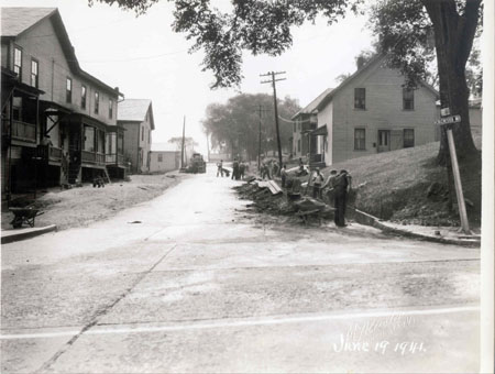
16., 17. & 18. BARRETT STREET AT COLCHESTER AVENUE June, August and October 1941 Louis L. McAllister shot these three images over a four month period in 1941. They look to the east from the intersection of Colchester Avenue and Barrett Street. Twelve years after completing work along Colchester Avenue, the Burlington Street Department returned to the neighborhood to improve the conditions on Barrett Street by constructing new concrete sidewalks on the north side, curbing and gutters on both sides, and paving the road. The 1941 Annual Report describes the latest materials used in road paving technology: a Telford stone base with asphalt penetration binder course and asphalt hot plant mix wearing course [and] underground drainage tile with integral concrete curbing and gutters.[1] Ten laborers are shown at work digging a ditch for the drainage system on the north side of Barrett Street in the photograph dated June 19, 1941. In the next image, taken six weeks late on August 4, 1941, the new curbs and gutters have been completed and a sidewalk that extends the length of the street has been built. A crew at work in the middle of the road is vaguely discernible in the background of this image. The last image, dated October 17, 1941, illustrates the completed job.
A section of Colchester Avenue visible in the foreground of all three images shows the concrete pavement that was installed in 1929. Transverse and longitudinal joints between the slabs can be discerned. The buildings at 11 and 17-21 Barrett Street are visible on the right sides of these images. Built between 1869 and 1889,[2] number 11 is a simple two by two bay, one and one-half story structure with the gable ends perpendicular to the street. The entry is protected by a simple extended porch with a shed roof supported by two posts and a wood railing. A side door is visible on the west elevation and a one story ell projects from the rear. There is no occupant listed at this address in the 1941 City Directory. Beyond it, the façade of the tenement at 17-21 Barrett Street, built between 1889 and 1906, is visible.[3] Employees of the American Woolen Company are listed as tenants here in 1941.[4] The large building at 6-10 Barrett Street, known as the Hickock-Burlington Cotton Company Tenement Building, is located across the street, on the north side (on the left in the images). It has had a long and complex history, researched by Thomas Visser for a proposed amendment extending the boundaries of the Winooski Falls National Register District in 1986. The oldest part of the structure dates to circa 1790, with later additions and alterations in 1853, 1924, 1961, 1988 and 1993. According to Visser: "The building consists of two parts. The first is a wooden clapboard 2-story gable-roofed house with a 2-story wing extending to the east along Barrett Street, built around 1790 and altered around 1853 when a section of the building was removed to allow space for Barrett Street. In 1924, a lower, flat-roofed 2-story addition was built as a storefront facing Colchester Avenue Possibly one of Burlingtons oldest buildings however, and probably the oldest surviving at Winooski Falls, 6-10 Barrett Street served as a store and tavern during the early commercial development of Winooski Falls. Perhaps reflecting its close proximity to the saw mills, it features an unusual construction technique of thick wooden planks rising from sill to plate which are mortised into a sawn post-and-beam frame."[5] In the McAllister photographs, several veranda-style raised porches provide shelter and shade for the doorways to the tenement apartments. However, the 1941 City Directory lists only two tenants at this address: Sara Doria, a widow, and Leo Lavigne, a spinner employed by the American Woolen Company.[6] On the verso McAllisters photographic print number 17, the text describes the building as the Pichierri apartment house.
The front of the next building along Barrett streets north side, number 14, is also visible in the three images. According to Vissers research, this structure was originally the southern half of 6-10 Barrett Street, but this rectangular 2-story gable-roofed dwelling was moved to its present location in the mid-nineteenth century.[7] In 1853 the city of Burlington created Barrett Street to connect the lower part of Colchester Avenue with the new road to South Burlington. A third structure on this side of the street, at 32 Barrett Street, is visible in the first two images taken in June and August 1941. The structure seems to have disappeared in the photograph taken in October of the same year. This house was moved back from the street by the City Street Department in order to make room for the new sidewalk. [1] Annual Report of the City of Burlington (1941-42). [2] Beers Atlas Map (1869) and Sanborn Insurance Map (1889). [3] Sanborn Insurance Maps (1889, 1906). [4] Burlington City Directory (1941). [5] Thomas D. Visser, Winooski Falls Historic District, Proposed Boundary Increase, Amendment to National Register Nomination (1986). [6] City Directory (1941). [7] Visser, Winooski Falls Historic District.
|
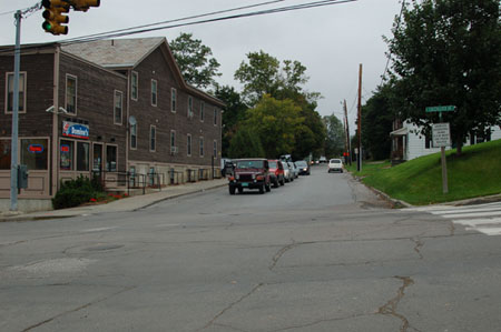
16. BARRETT STREET AT COLCHESTER AVENUE October 11, 2005 (18T 0644176 UTM 4927665) The streetscape has stayed essentially unchanged since McAllister photographed the street work in 1941, with the exception of the loss of the large shade tree in the right foreground and the addition of a traffic signal. The curbs and sidewalks are the same and even the street sign remains in the same position. The building at 14 Barrett Street has been removed, however; replaced by trees visible in the middle ground of the recent image. The south elevation of 6-10 Barrett Street has been altered by the removal of the raised porches at the first floor level above grade. The fenestration pattern on this façade has also been changed, with the irregular rhythm of the second-story windows visible in the 1941 images replaced by six evenly-spaced lights, perhaps to accommodate alterations to the interior of the structure. and 1986 PHOTOGRAPH
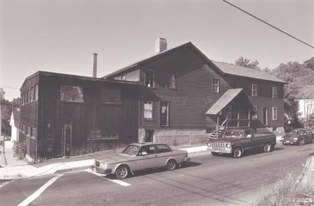
Here is another photograph from Thomas Vissers proposal for an amendment to the Winooski Falls National Register District.[1] Although the exterior appearance of 6-10 Barrett Street has been very significantly changed since 1941, its structure and form are intact. The fenestration pattern on the older parts of the building also are preserved here and several of the double-hung two-over-twos appear to date from the second half of the nineteenth century. [1] Thomas D. Visser, Winooski Falls Historic District, Proposed Boundary Increase, Amendment to National Register Nomination (1986). |
Colchester Avenue east of East Avenue, Barrett and Mill Streets
Historic Burlington Project Burlington 1890 | Burlington 1877 | Burlington 1869 | Burlington 1853 | Burlington 1830 Produced by University of Vermont Historic Preservation Program graduate students in HP 206 Researching Historic Structures and Sites - Prof. Thomas Visser in collaboration with UVM Landscape Change Program Historic images courtesy of Louis L. McAllister Photograph Collection University of Vermont Library Special Collections |