
 |
 |
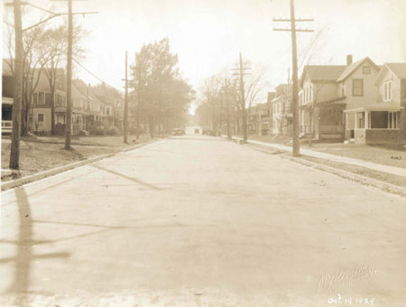
3. COLCHESTER AVENUE SIX WEEKS LATER October 19, 1929 The condition of the street is wider, smoother and flatter after the asphalt paving has been installed. This photograph was taken six weeks after the last one (image number 2.) It was shot from the middle of the street on Colchester Avenue, looking west from near the entrance to Green Mount Cemetery. The road has been widened by approximately nine feet along the south side.. New concrete curbing and gutters are in place where the streetcar tracks have been removed. In this image, the facades and east elevations of many of the buildings along Colchester Avenue are visible. On the left side are a series of two-story Victorian style houses (numbers 315, 311, 307 and 303), characterized by their extended porches, hip and gable roofs and turrets. The 1929 City Directory lists Eusebe A. Mitiguy, a commercial traveler, as head of the household at 311 Colchester Avenue and four other Mitiguys reside at the same address: Blanche, Edith, Edmund and Gertrude.[1] Older structures occupy the north side of the street, including 316, 314 and 312 Colchester Avenue. Numbers 312 and 314 appear on the 1869 Beers Atlas map as the property of C. Benns.[2] The 1889 and 1906 Sanborn Insurance maps of Burlington show no exposure for Colchester Avenue from East Avenue to the Green Mount Cemetery, likely because there were few commercial or industrial properties in this area. However, the 1919 Sanborn map does contain an insert with this area shown. By comparing it with the 1926 Sanborn map, it appears that 316 Colchester Avenue was formerly a shed attached to number 314. This is significant because the structure at number 316, both because of its scale and siting, appears much older than if it were constructed between 1919 and 1926.[3] [1] Burlington City Directory (1929). [2] See Sabrina Carlson, Burlington 1869: North Prospect Street East to the Winooski River, 2002, http://www.uvm.edu/~hp206/2002-1869/scarlson/html (November 5, 2005), for detailed descriptions of 312 and 314 Colchester Avenue. [3] See Beers Map of Burlington (1869), and Sanborn Insurance Maps (1919 and 1926).
|
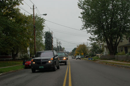
3. COLCHESTER AVENUE FROM NEAR THE ENTRANCE TO GREEN MOUNT CEMETERY October 11, 2005 (18T 0644068 UTM 4927236) In this recent image, a few details of the structures can be seen behind the trees and line of traffic. At 316 Colchester Avenue, the extended porch has been rebuilt and enclosed under a shallow hip roof. |
Colchester Avenue east of East Avenue, Barrett and Mill Streets
Historic Burlington Project Burlington 1890 | Burlington 1877 | Burlington 1869 | Burlington 1853 | Burlington 1830 Produced by University of Vermont Historic Preservation Program graduate students in HP 206 Researching Historic Structures and Sites - Prof. Thomas Visser in collaboration with UVM Landscape Change Program Historic images courtesy of Louis L. McAllister Photograph Collection University of Vermont Library Special Collections |