
 |
 |
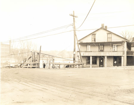
26. 495 COLCHESTER AVENUE (no date) This photograph of 495 Colchester Avenue looking east with a view of the Winooski River and the riverbank beyond it was likely shot at the same time as images 11 and 14. Since the new bridge abutments visible in image 15 are not yet in place here, it certainly was taken before August 1928 when the bridge was opened. This would seem to date the image to the winter or spring of 1928, fewer than six months after the flood of November 1927. According to Visser, the commercial structure at 495 Colchester Avenue was built between 1841 and 1846 and from that time it served as a store, a blacksmith and wheelwright shop, then a second hand thrift store and again as a grocery store in 1912.[1] When McAlister took this image it most recently had been used to sell furniture and stoves, as evidenced by the large sign affixed to the railing of the second story porch. The ground floor of the building, while not boarded up, appears to be vacant. The City Directory in 1929 lists Sarkis Boyakian, a laborer, as the only tenant at this address.[2] The building, sometimes called the Duncan-Dubuc Blacksmith Shop,[3] is a three story, three-by-five bay brick structure with the gable end facing Colchester Avenue. It has a shallow pitched roof with wide cornice returns. A central entry is flanked by shop windows and a double door on the ground floor. Three two-over-two sash windows are spaced regularly on the second story. The lintels of the two windows on the third floor are partially covered by the frieze moulding of the gable end. The two story porch is supported by four square columns below and five turned posts rising from the railing above. Delicate spindles form a narrow band under the porchs flat roof. Utility poles and lines and an electric line for streetcars are visible in the foreground. A temporary wood fence blocks vehicles access to Mill Street, which begins just to the left of the commercial building. Perhaps work to clear the damage wrought by the flood was still taking place. [1]Thomas D. Visser, Winooski Falls Historic District, Proposed Boundary Increase, Amendment to National Register Nomination (1986). [2] Burlington City Directory (1929). [3] David J. Blow, Historic Guide to Burlington Neighborhoods, Vol. 2 (Burlington: Chittenden County Historical Society, 1997), 102.
|
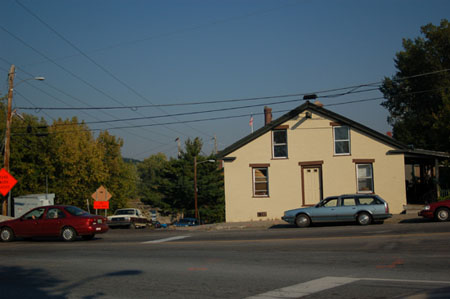
26. 495 COLCHESTER AVENUE October 3, 2005 (18T 0644165 UTM 4927710) At first glance, the building in the recent image bears few similarities to the one shown in the McAllister photograph from the late 1920s. It now has a facade two stories high, with a central doorway. There is no porch. But they are indeed the same structure In order to construct a higher bridge over the Winooski River after the flood of 1927, the grade of the road was raised to the level of the second floor at 495 Colchester Avenue. Eight feet of fill was added to the area where the street met the bridge abutment.[1] Thus the ground floor of the building is now underground on its west side. [1] Annual Report of the City of Burlington (1929), 238-239. |
Colchester Avenue east of East Avenue, Barrett and Mill Streets
Historic Burlington Project Burlington 1890 | Burlington 1877 | Burlington 1869 | Burlington 1853 | Burlington 1830 Produced by University of Vermont Historic Preservation Program graduate students in HP 206 Researching Historic Structures and Sites - Prof. Thomas Visser in collaboration with UVM Landscape Change Program Historic images courtesy of Louis L. McAllister Photograph Collection University of Vermont Library Special Collections |