
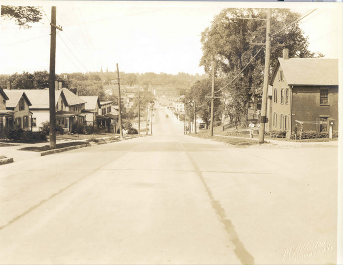
Colchester Avenue east of East Avenue, Barrett and Mill Streets
Burlington, Vermont
Text and recent photographs by Jean Innamorati
INTRODUCTION
Although not essentially part of the Old North End neighborhood of Burlington, the eastern section of Colchester Avenue and Mill and Barrett Streets are related to it by affinity. Building styles and the ethnic characteristics of residents during the late 1920s, 1930s and early 1940s are similar in both the North End and the more peripheral area of Colchester Avenue and its environs. As it extends from East Avenue toward the Winooski River, Colchester Avenue shifts from solid middle class to a more modest working class milieu as its structures gradually change from single family homes on average-size city lots to more cramped properties and, finally, tenement housing clustered around the woolen mill on the riverfront. There are a few artisans’ shops, a gas and service station and a grocery and general store near the mill as well. Colchester Avenue in these years was the principle thoroughfare linking Burlington to the smaller industrial town of Winooski; indeed, the city limits end at the Winooski Bridge.
While Burlington grew rapidly during the last decades of the nineteenth century, from 1920 to 1940 its population grew from 22,799 to 27,686,[1] an increase of only about 20%. Yet that Burlington witnessed any growth is significant, considering that the major manufacturing enterprises in the city, including the woolen mills, were on the wane during these decades that included the disastrous flood of 1927 and the Great Depression.
According to the federal census of 1930, approximately 40% of Burlington’s residents at that time were either immigrants or first generation Americans. French Canadians made up the largest group, comprising about 20% of the total population, followed by English-speaking Canadians, Irish, Russians and Poles. Smaller ethnic groups included the English, Italians and Germans.[2] In his ethnographic study of Burlington, We Americans: A Study of Cleavage in an American City, Elin Anderson claims that the 1930 census figures underestimated the size of ethnic groups within the city because of their failure to account for second and even third generations of immigrant families. By his reckoning, 40% of Burlington’s residents were of French Canadian origin and another 28% included Irish, Italians, Jews, Syrians and twenty-nine other ethnic groups.[3] If these figures are accurate, during the 1930s more than two thirds of its residents were relative newcomers to Burlington.
Thus, like most American cities in the early decades of the twentieth century, Burlington had a diverse ethnic populace. There is evidence of this diversity, in fact, in the names of residents on Colchester Avenue, Mill and Barrett Streets listed in the city directories for these years. Anderson summarized the immigration pattern:
"Between 1860 and 1875 the influx of foreigners increased with the boom in the lumber industry. The demand for laborers brought more French Canadians and Irishmen; by 1880 there was a small colony of Germans; by 1885 there were enough Jews to support a synagogue, and by 1890 a group of Italians had come in to dig sewers, and to build roads at the military post situated five miles from Burlington. In the late nineties Burlington felt the reverberations of the wave of immigration which brought hundreds of new Americans from southeastern Europe… Thus by the turn of the century the character of Burlington had altered markedly from that of its early beginnings. The change since then has been slower. The only continuous movement of recent times has been that of the French Canadians, who still come down across the border to find work in the textile mills which were Burlington’s last gesture toward becoming an industrial city before it settled into its present character as a commercial and educational center."[4]
Later in his study, Anderson describes the demographics of Burlington’s neighborhoods, concluding that the head of a household’s occupation was the single most important index of social and economic status, often also determining the neighborhood in which a family lived. Furthermore, he states that there is a tendency to identify ethnic groups by the industry in which the majority of their members worked: “thus, the French Canadians are identified with the cotton and woolen mills… the Poles with iron foundries, the Italians with road-building and ditch digging, the Greeks with restaurants, the Chinese with laundries.” [5] Again, Anderson’s observations are supported by the occupations listed in the city directories for the residents of Colchester Avenue, Mill and Barrett Streets. Spinners, weavers and laborers at the American Woolen Company Mills lived in the vicinity of the factories, alongside a baker, a barber, two carpenters, laborers, masons, other blue collar workers and several widows. Further up the hill along Colchester Avenue, the occupations listed in the directories shift to salesmen, commercial travelers, clerks, bookkeepers and town and university employees. The directories also indicate that most of the residents lower on the hill, near the river, rented their homes, while atop the hill, closer to the hospital on the western end of the avenue, property owners lived in their own dwellings.[6]
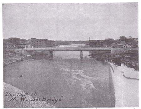
The economic prosperity that characterized the 1920s was abruptly interrupted by the disastrous flooding throughout Vermont that occurred in early November 1927. The iron bridge that spanned the Winooski River, connecting Colchester Avenue to Winooski, was swept away. The city detonated explosives to destroy the Johnson Grain Company’s building, the site of an early grist mill along the lower falls of the river, to create a wider channel for the floodwaters and prevent further damage to the area along the riverbanks.[7] But the city, like the rest of the state, rallied quickly to rebuild after the disaster, in which 84 people were killed and $30 million worth of property was lost statewide, at a time when the average wage was $20 per week.[8] The US Army Corps of Engineers sent a company from Delaware to build a temporary pontoon bridge, accessible only to pedestrian traffic, across the river. The work was directed by Lieutenant Leslie R. Groves, who, as a major general during World War II, would go on to direct the Manhattan Project for the development of atomic weapons.[9]

-- Winooski Bridge prior to the flooding in November 1927 -- -- New steel and concrete bridge just after completion in 1928 --
(Both photos from Annual Report of the city of Burlington,1929)
Within a year, the city constructed a new permanent bridge, made of steel plate girders and reinforced concrete spans, designed by J.R. Worcester and Company of Boston.[10] The Burlington company of James E. Cashman was the contractor. His company was also responsible for building Burlington City Hall, Memorial Auditorium and the YMCA. In another curious aside, Cashman, brother of the chief engineer of the Cape Cod Canal project, moved to Burlington to escape the large shadow cast by his successful sibling.[11]
The new bridge opened on August 4, 1928. Robert B. Michaud recalls the great fanfare of the occasion:
"At 1:30-2:00 p.m. there was a band concert held at each end of the bridge. The 7th Field Artillery Band from Fort Ethan Allen played on the Burlington side and the Burlington Military Band on the Winooski side, and then each band marched to the other side of the bridge. A motorcade of notables passed over the bridge each way and opened this vital link to the Chittenden County communities, a link that still carries much of the commuter traffic across the Winooski."[12]
The celebratory atmosphere would be short lived, however. Two years after the flood, another devastating event disrupted prosperity, this time on a national and international level. The Wall Street stock market crashed on October 29, 1929. Burlington, along with the rest of the country, would experience a severe economic slump lasting a decade.
The earliest images in the photographic record of Colchester Avenue, Mill and Barrett Streets from the Louis L. McAllister Collection[13] date to a few weeks before the Stock Market Crash of 1929. They document road construction work, as well as the buildings and landscapes, along these streets from 1929 until 1941. They are accompanied by recent digital images taken from the same viewpoints as the McAllister photographs and show the changes to structures and streetscapes over the next sixty-four to seventy-six years.
[1] Annual Reports of the City of Burlington, Vermont. (1920, 1930, 1940).
[2] Elin L. Anderson, We Americans: A Study of Cleavage in an American City (New York: Russell and Russell, 1937), 17-18.
[3] Anderson, 18-20.
[4] Anderson, 20-21.
[5] Anderson, 53.
[6] Manning’s Burlington, Winooski and Essex Junction (Vermont) Directories (Springfield: H.A. Manning Company, 1929,1935,1941).
[7] Luther B. Johnson, The ’27 Flood (Randolph Center: Greenhills Books, 1928), 107-109.
[8] Johnson, i.
[9] Bygone Burlington: A Bicentennial Barrage of Battles, Boats, Buildings and Beings, (Burlington: Burlington Bicentennial Committee, 1976), 51.
[10] Annual Report of the City of Burlington (1928), 227.
[11] Bygone Burlington, 51.
[12] Robert B. Michaud, Salute to Burlington: An Informal History of Burlington, Vermont (Lyndonville: Lyndon State College, 1991), 134.
[13] Louis L. McAllister, “Burlington Street Department Photographs.” (Burlington: UVM Bailey/Howe Library, Special Collections, c.1929-1941).
Additional Information
Anderson, Elin L. We Americans: A Study of Cleavage in an American City. New York: Russell and Russell, 1937.
Annual Reports of the City of Burlington, Vermont, 1929-1945.
Barlow, Phillip L. “Burlington 1877: 452 Colchester Avenue.” 2003. http://www. uvm.edu/%7Ehp206/2003-1877/pbarlow/1877/452%20colchester.html.
Beers Map of Burlington, 1869.
Blow, David J. Historic Guide to Burlington Neighborhoods. Vol. 2. Burlington: Chittenden County Historical Society, 1997.
Burlington City Directories. 1905-1941.
Bygone Burlington: A Bicentennial Barrage of Battles, Boats, Buildings and Beings. Burlington: Burlington Bicentennial Committee, 1976.
Carlson, Sabrina. “Burlington 1869: North Prospect Street East to the Winooski River.” 2002. http://www.uvm.edu/~hp206/2002-1869/scarlson/html.
Davis, Allen F. Postcards from Vermont: A Social History. Hanover: University Press of New England, 2002.
Fuller, Edmund. Vermont: A History of the Green Mountain State. Montpelier: State Board of Education: 1952.
Hill, Ralph Nading. The Winooski: Heartway of Vermont. New York: Rinehart and Company, 1949.
Hyde, Arthur L. And Frances P. Burial Grounds of Vermont. Bradford: Vermont Old Cemetery Association, 1991.
Jennison, Peter S. Roadside History of Vermont. Missoula: Mountain Press Publishing Company, 1989.
Johnson, Luther B. The ’27 Flood. Randolph Center: Greenhills Books, 1928.
McAllister, Louis L. “Burlington Street Department Photographs.” Burlington: Bailey/Howe Library, c.1928-1950.
Michaud, Robert B. Salute to Burlington: An Informal History of Burlington, Vermont. Lyndonville: Lyndon State College, 1991.
Reimann, Liisa. “Burlington 1877-1890: 9-11 Barrett Street.” 2004. http://www.uvm. edu/~ hp206/2004-1890/burlington1890/website/lreimann/winooskiBridge/ ?Page=9-11barrett.html.
Sanborn Insurance Maps, 1889, 1906, 1912, 1919, 1926, 1938, 1961.
Visser, Thomas D. “Winooski Falls Historic District, Proposed Boundary Increase, Amendment to National Register Nomination,” 1986.
Back to index for COLCHESTER AVENUE EAST OF EAST AVENUE, BARRETT AND MILL STREETS
Historic Burlington Project Burlington 1890 | Burlington 1877 | Burlington 1869 | Burlington 1853 | Burlington 1830 Produced by University of Vermont Historic Preservation Program graduate students in HP 206 Researching Historic Structures and Sites - Prof. Thomas Visser in collaboration with UVM Landscape Change Program Historic images courtesy of Louis L. McAllister Photograph Collection University of Vermont Library Special Collections |