Pitkin Street
For not even having a name on the 1869 Beers Atlas Map, Pitkin Street proved to be full of history. Six structures appear on this street that do not appear on the 1853 Presdee and Edwards map, as well as the addition of the Chittenden County Agricultural Society. Five of the buildings possibly survive. Deed research proved to be the most enlightening for this street, as there were no names listed on the map for initial directory research. For the largest parcel on this street, the Deed Register listed a transaction between L. S. Drew and the Chittenden County Agricultural Society for "21 Acres Fair Grounds."1 It seems from research that the name Murphy controlled this area, as up through the 1890's various members of the family continued to live here.
14-16 Pitkin
Current aerial maps show a similar footprint as on the 1869 map. This structure also looks almost identical to 66 North Street, just around the corner, suggesting a possible common builder. The 1881 City Directory lists Patrick Murphy, tinsmith, at this location. Deed Records for 1866 show an entry from Patrick Foy to Patrick Murphy "Lot No. 12 on street next east of fair grounds."2 No name appears next to this structure on the 1890 Hopkins map, but the 1899 Directory again puts Patrick Murphy at this location. This house apparently stayed within the same family for more than 30 years, unlike some of the other structures in this area that were built specifically for, or turned into, multiple housing units for laborers.
32 Pitkin
This building too was owned by a Murphy. It currently shows a similar footprint to the 1869 map. The 1881 Directory lists Michael Murphy, who had billiard rooms at 143 Main, at this location. 1866 Deed records have an entry from L. Underwood to Michael Murphy for "Lots 10 and 11 on street next east of fairgrounds."3 The 1890 Hopkins map shows a Murphy still at this address, and the 1899 Directory again lists Michael Murphy here.
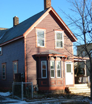
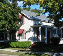
38 Pitkin
The final Murphy to have a home on Pitkin by 1869 was William P. Murphy. An 1866 Deed Register entry states L. Underwood to William Murphy lots 1 and 2 north of North st. Adjoin fairgrounds."4 The 1881 Directory lists him here, as does the 1899 directory. Interestingly, the 1890 Hopkins map lists Mrs. W.P. Murphy at this site. It is possible that between 1890 and 1899, William P. Murphy Junior began living here, as it does not seem likely Mrs. Murphy would be listed singularly on the 1890 map if her husband were still living. The house today seems to be almost exact to the footings of 1869 and 1890 and is well kept.
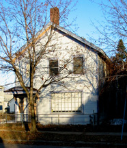
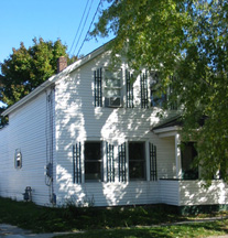
54 Pitkin
Current aerial maps show a somewhat similar footprint to that of 1869. This structure, however, has undergone many cosmetic changes, and it is therefore hard to determine whether this is the original structure. The 1881 Directory lists N. Tracy at this location. This name does not appear in the 1869 Directory, but the 1871 Directory lists N. Tracy, a carpenter, living "On Pitkin St. near North Bend." The name N. Tracy appears at this location on the 1890 Hopkins map. It seems that this building too stayed in one family until the turn of the century. More research would be needed, however, to determine if any of the original building survives.
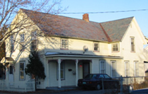
60 Pitkin
As with the previous address, this building currently has a similar footprint to the 1869 Beers map. Cosmetic changes, and the addition of a one level flat roof addition at the rear, make it difficult to determine if this is the original structure. Little information is found regarding this location. The 1881 Directory lists a Binois here, but the name does not appear in years prior or subsequent. Unlike other houses on this block, this address revealed little history. The 1890 Hopkins map lists J.W. Hayes at this location. As Hayes owned other properties in town, it is possible this housed laborers by 1890.
____________________
1 Burlington City/Town Records, Box 5, 1866-67, p. 15.
2 Ibid, p. 7.
3 Ibid, p. 3.
4 Ibid, p. 9.