
 |
|
|
|
|
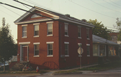
42 King Street bears striking resemblance to 46 King Street,
which is directly across Champlain St. Both houses are on corner
lots, they both are the same height, and extend to the North with
their gable ends facing King Street. This house is also listed
on the National Register of Historic Places nomination form for
the Battery Street Historic District. The nomination form claims
the house was built before 1853, probably because of the Presdee
and Edwards map in which this house appears under the name Chapman.1
This was most likely Thomas D. Chapman also who resided on Pine
Street for some time as well.2 The 1869 Beers map
lists this as the "Franklin House"3 although
there is no record of a transaction between anyone named Franklin
and anyone named Chapman.
The cornice line on this house continues around the front of the
building to create an enclosed pediment on the gable end. Within
the pediment is an elliptical fanlight. The brick house also
has heavy stone lintels and an elevated entranceway located on
the western side of the building, the mirroring 46 King Street.
Although the two houses differ slightly, the resemblance certainly
suggests a similar influence and possibly the same builder. Like
46 King Street this house is also made up of a brick bond that
includes seven courses of stringers followed by a course of headers.
On the western façade of the building there is a wrap
around porch that ends with a brick wall extending from the house.
This brick wall is only about four feet long and then it abruptly
turns to wood. At the end of the wooden wall there is a modern
wing extending to the West. This transition between the wood
and brick wall is further emphasized by the depth that the wood
is sunken back in comparison to the brick. On the 1853 Presdee
and Edwards map4 the house continues to the North,
where this wooden wall is. It then continues around to the West,
similar to the modern wing, in what appears to be an array of
sheds. This difference in wall materials shows where the original
house ends and its resemblance to the Presdee and Edwards map
footprint is evidence it is the same house that was present in
1853.