
The NTL Green Plan model combines several protected lands layers (polygon shapefiles)
into a single protected lands layer and performs an analysis that is used to identify
"hubs" of protected land that might serve as the core areas of a more well-connected
network of protected land. Hubs are scored based on landscape and other characteristics.
A final product for SE Pennsylvania is shown here:
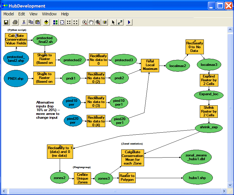
The analysis is divided into 3 separate models. The first converts several input layers to raster format and
makes use of some Spatial Analysis tools. All input polygons have scores, and the model preserves
the highest scoring areas by way of the Local Maximum tool (Bucks County is a special case treated
differently). An expand/shrink process then subsumes any tiny areas adjacent to larger areas. The resulting
contiguous areas of protected land are given a mean score via Zonal tools. These areas of protected land
(protected_land1.shp) are manually joined with the zonal means DBF table before proceeding with the next model.

The second model adds other inputs and performs more of the same operations with the addition of a Python script
that calculates conservation value for the protected lands produced by the first model (protected_land2.shp). As before,
the output shapefile and DBF table are manually joined before proceeding with the third model.
The third model simply runs the same Python script to calculate conservation values for hubs identified in
the second model.

July 2005 . . . . questions/comments to: David Felcan, Avencia, Inc.