Post-Meeting Content
VMC has made available as much content from the meeting as possible. You can
- - Watch videos of the invited speakers at the plenary session
- - Read abstracts, download talks and watch video of the afternoon contributed presentations
- - read summaries of the afternoon working sessions, and
- - view the posters presented at our poster session
In addition, VMC will again be publishing a proceedings for the conference, so check back in early 2015.
Plenary Session: Insider advice on maximizing the impact of our work at local, regional and national scales
As environmental professionals we are well trained in studying and protecting natural resources, but may be less informed on how to translate our findings into actionable change. While the general public is often included in our outreach efforts, we all-to-often fail to communicate our findings to policy makers where these results can be considered for maximum long-term impact. The challenge to our community is to provide useful information to the appropriate decision makers in a timely manner. In 2014, VMC partnered with the UVM Environmental Program to provide our community with insider advice on maximizing the impact of our work at local, regional and national scales
Deb Markowitz, Secretary, Vermont Agency of Natural Resources
Due to technical difficulties, the first few minutes of this video are missing
Tom Berry, Policy Advisor on Agriculture, Conservation, Energy and Natural Resources to Senator Patrick Leahy
Rebecca Ellis, Vermont State Representative and Vice Chair of the House Natural Resources & Energy Committee
Jamey Fidel, General Counsel & Forest and Wildlife Program Director, Vermont Natural Resources Council
Dan Lambert, Conservation Project Leader, High Branch Conservation Services
Due to technical difficulties, only the first half of this talk is available
Back to Top
Contributed Presentations: Forest ecosystem science and monitoring, resource management, and public policy.
Presentations on the new and ongoing research, monitoring, conservation and outreach initiatives from around the region.
| Session A Moderator: Alison Adams |
Session B Moderator: Olivia Lukacic |
Session C Moderator: David Gudex-Cross |
Session D Moderator: Elizabeth Perry |
♦MMSSC Session Moderator: Dan Lambert |
|---|---|---|---|---|
Long-term Monitoring Plots on the Green Mountain National Forest Diane Burbank ABSTRACT VIDEO PRESENTATION | Incorporating the Next Generation of Water Monitoring in Vermont Keith Robinson ABSTRACT VIDEO PRESENTATION | Effects of landscape development on bobcat carrying capacity in Vermont James D. Murdoch ABSTRACT VIDEO PRESENTATION | Mapping Vermont From Above: Turning Data Into Information Jarlath O'Neil-Dunne ABSTRACT VIDEO PRESENTATION | ♦ When One Tugs on Mount Mansfield, You Find it Attached to the Rest of the World: Discoveries in Songbird Population Connectivity. Kent McFarland and Chris Rimmer ABSTRACT VIDEO |
Long-term Monitoring Plots on the Green Mountain National Forest Diane Burbank, Marybeth Poli, Nancy Burt Presenter: Diane Burbank, USDA Forest Service, Green Mountain & Finger Lakes National Forests Long-term changes are occurring in Green Mountain National Forest (GMNF) ecosystems. Environmental changes such as changes in climate, atmospheric deposition, and the spread of non-native invasive species, are known have effects on forest vegetation and soils. We must better understand these changes and their effects in order to make sound land management decisions in the future. The Long-term Ecosystem Monitoring Project (LEMP) is a 50-year monitoring effort established to characterize and quantify changes to representative ecosystems on the GMNF over time. Site selection criteria were used to locate permanent plots across the geographic range of the GMNF, within the dominant natural communities and soils of the Forest. Plot design is based on a modification of FIA plot design, and plots are intended to be sampled every 10 years for 50 years. Plots are located in areas with minimal evidence of past anthropogenic disturbance. Twenty plots were established between 2008 and 2011. Data is gathered on site characteristics, all layers of vegetation, soil, lichens, and down woody material occurs during each sampling session. Soil samples are collected for analysis of pH, base cations, nutrient status, and mineralogy of the subsoil; soil samples will be archived. The plots are intended to host monitoring of other factors of interest to the research community. Plot data is available to the research community in various forms. It will be used to quantify baseline conditions of soil and vegetation and associated trends, and will contribute to sensitivity models, regional long-term monitoring datasets, and science in general. | ||||
Incorporating the Next Generation of Water Monitoring in Vermont Keith Robinson Presenter: Keith Robinson, US Geological Survey In the past decade a number of new water monitoring and assessment techniques have been developed provide greater temporal, spatial and detailed assessments of water quality and quantity. A number of these new techniques, and examples of how they can be used to address water resource issues in Vermont, will be presented. Continuous water quality monitors, using acoustic technology to measure sediments and other water quality issues and generation of continuous contaminant load estimates to receiving waters, are examples of how water quality measurements are being made in many areas of the Nation. These techniques apply to many critical water quality issues in Vermont. From a water quantity standpoint, use of continuous monitors of river stage, together with mapping technology can arm local emergency management officials with the information they need to prepare for and respond to imminent flooding. Although many of these new techniques require new data collection and data analysis, they may provide enhanced resource data that we find we can not eventually live without. | ||||
Effects of landscape development on bobcat carrying capacity in Vermont James D. Murdoch, Wendy Cole, Therese Donovan, Michelle Brown Presenter: James D. Murdoch, University of Vermont The bobcat (Lynx rufus) is a nocturnal, secretive, and territorial carnivore that occurs throughout Vermont. The species is listed as a Species of Greatest Conservation need in the state and considered susceptible to landscape change. Bobcats require distinct habitats, but little information exists on how changes in the amount and distribution of those habitats, especially due to human developments, affect the population. We examined the effect of housing and road development on the bobcat population in Vermont. We used radio-telemetry data to develop a habitat suitability model for males and females, then mapped suitability across the state and used a technique called maximum clique analysis to estimate the bobcat carry capacity now and under conditions in 2050. We estimated conditions in 2050 using models of projected rates of housing and road development. Our analysis provides a quantitative estimate of how projected changes in development levels affect bobcat carrying capacity. We discuss the ecological and genetic implications of our results, and their impacts on bobcat management and land use planning. We also provide an overview of how our approach can be easily modified to estimate carrying capacity for other territorial species in the state. | ||||
Mapping Vermont From Above: Turning Data Into Information Jarlath O'Neil-Dunne, Sean MacFaden, Ernie Buford, and Anna Royar Presenter: Jarlath O'Neil-Dunne, University of Vermont From multispectral data acquired from satellites to 3D models generated from airborne LiDAR sensors to centimeter resolution imagery taken by unmanned aerials systems – the amount of data acquired for Vermont from above has grown exponentially over the past 5 years. This presentation will explore these remotely sensed data sources and show the types of analyses that are being done to turn these datasets into information to help improve decisions making and drive policy. | ||||
♦ When One Tugs on Mount Mansfield, You Find it Attached to the Rest of the World: Discoveries in Songbird Population Connectivity. Kent McFarland, Chris Rimmer Presenter: Kent McFarland and Chris Rimmer, VT Center for Ecostudies Geolocation and songbird conservation | ||||
A long-term examination of changing species assemblages in a northern hardwood forest Jennifer Pontius ABSTRACT VIDEO PRESENTATION | Wilderness Streams in the GMNF:creating a chemical baseline Heather Pembrook ABSTRACT VIDEO PRESENTATION | The Vermont Reptile and Amphibian Atlas, Highlights from the 2014 Season Jim Andrews ABSTRACT VIDEO PRESENTATION | Subdivision and Land Use Change at the Municipal Level: An Analysis of Trends and Strategies for Maintaining Intact Forests in Vermont. Jamey Fidel ABSTRACT VIDEO PRESENTATION | ♦ Photo-Monitoring in Mt. Mansfield's Alpine Zone Elisabeth Fenn ABSTRACT VIDEO PRESENTATION |
A long-term examination of changing species assemblages in a northern hardwood forest Jennifer Pontius, Joshua Halman, Paul Schaberg Presenter: Jennifer Pontius, UVM and USFS NRS Long-term forest inventories provide a unique opportunity to quantify changes in forest structure, as well as how changes may deviate from historic models of species succession and biomass accumulation. An examination of a 70-year record on mid-late successional stands at the Bartlett Experimental Forest, NH, USA indicated that species abundances have changed as expected under natural succession, with significant increases in shade tolerant species such as American beech (Fagus grandifolia ) and eastern hemlock (Tsuga canadensis), and decreases in early successional species such as paper birch (Betula papyrifera). However, interesting deviations were detected, including significant decreases in red (Acer rubrum) and sugar maple (Acer saccharum) resulting from reduced regeneration rates over the survey period. Other deviations included increases in red spruce (Picea rubens) biomass at the expense of sympatric balsam fir (Abies balsamea) and hardwoods at upper elevations. We conclude that while natural succession continues to dominate changes in species demographics, the influence of changing climate and the legacy of acid deposition may be altering competitive dynamics, favoring species like red spruce and American beech over their common counterparts in northeastern forests. | ||||
Wilderness Streams in the GMNF:creating a chemical baseline Heather Pembrook Presenter: Heather Pembrook, VT DEC Wilderness streams were sampled by the GMNF and the VTDEC 3 times in 2014 to establish a baseline of water chemistry values, as recommended in the 2013 USFS Air Quality Value Monitoring Plan. This information will be used by both the State of Vermont and the GMNF to determine the status of flowing waters in Vermont’s wilderness areas across a geographic range, from the West Branch of the Deerfield in the George Aiken Wilderness area in Stamford to the North Pond Outlet in the Bristol Cliffs wilderness area. Preliminary results and beautiful photos of these hidden treasures will be presented. This work was funded in part by the Green Mountain National forest through a cost share Agreement with the State of Vermont. | ||||
The Vermont Reptile and Amphibian Atlas, Highlights from the 2014 Season James S. Andrews Presenter: Jim Andrews, The Vermont Monitoring Cooperative and The Vermont Reptile and Amphibian Atlas During the 2014 field season the Vermont Monitoring Cooperative continued to support both intensive amphibian monitoring at Mt. Mansfield and the extensive monitoring of the Vermont Reptile and Amphibian Atlas. We have not yet processed the intensive monitoring data for 2014; however, for our extensive monitoring efforts we have developed a new "hit list" of needed reptile and amphibian documentation and made it available on our website. Visits with survey teams to some of our least-well surveyed areas filled in many documentation gaps. Reports from the public included rare potential breeders such as the Eastern Box Turtle as well as reports of the North American Racer. The racer had not been documented in Vermont since 2008. | ||||
Subdivision and Land Use Change at the Municipal Level: An Analysis of Trends and Strategies for Maintaining Intact Forests in Vermont. Jamey Fidel Presenter: Jamey Fidel, General Counsel/ Forest and Wildlife Program Director Vermont Natural Resources Council This presentation will explain the relationship of subdivision and land use change at the municipal level in fourteen case study towns Vermont. Recent research focused on subdivision trend analysis, case studies, and conclusions about effective and problematic zoning approaches for maintaining viable tracts of forestland in Vermont. Research results demonstrate that a majority of subdivision activity is not being reviewed by Act 250, Vermont’s development review law, which means local municipalities are left to shape subdivision through local regulations. The presentation will discuss where subdivision is occurring, and whether certain municipal zoning approaches are more effective in controlling subdivision in forestland. Furthermore, the presentation will explain how subdivisions are lowering the amount of land that is eligible to be enrolled and conserved in the Current Use Program. Project partners coordinated with regional and local planning entities to discuss the research results and develop replicable strategies for planning and zoning to reduce the parcelization of forestland. This outreach effort resulted in a technical assistance manual and an online community planning toolkit showcasing effective planning and zoning techniques and non-regulatory strategies for maintaining forestland. Project partners also solicited input to develop a Forest Fragmentation Action Plan, which outlines nine of the most “effective” strategies to maintain forests in Vermont. The results of these efforts will be shared at the presentation. | ||||
♦ Photo-Monitoring in Mt. Mansfield's Alpine Zone Elisabeth Fenn and Kevin Hudnell Presenter: Elisabeth Fenn, Green Mountain Club Mt. Mansfield’s alpine zone is one of only three areas in Vermont where arctic alpine tundra thrives today. As it is also one of Vermont’s most popular hiking destinations, this rare ecosystem faces potential extirpation. In 1969, the Green Mountain Club, along with the Vermont Department of Forests, Parks, and Recreation, Stowe Mountain Resort, and University of Vermont, created the Ranger Naturalist Program, a new effort to educate hikers and combat the increased trampling along hiking trails above tree line in Vermont. This program has grown into the current Summit Caretaker Program, which watches over all of the alpine summits in the state.
We plan to re-launch a photo-monitoring program in the 2015 field season, which will continue work started by Matt Larson in 2004. Preliminary comparisons of sites documented in the 2004 study suggest that revegetation efforts in the alpine zone are succeeding. By analyzing photographs of multiple sites on a time frame separated by 11 years, we can make more informed decisions about the relative efficacy of our trail management techniques in order to strengthen our stewardship program. A large part of the Mt. Mansfield Caretaker Program is educating visitors who may have little previous experience with such a unique natural area. Having photographs that illustrate the progress we have made in protecting alpine vegetation, and emphasize the work that still needs to be done, will increase the effectiveness of our educational efforts.
| ||||
What are forest health indicators telling about future forests? Sandy Wilmot ABSTRACT VIDEO PRESENTATION | Extremes at elevation - high flow events on Mount Mansfield Jamie Shanley ABSTRACT PRESENTATION | Modeling the Impacts of Climate Change on Water Quality in Lake Champlain: Design of an Integrated Assessment Model using Pegasus Scientific Workflow Ahmed Abdeen Hamed ABSTRACT VIDEO PRESENTATION | Monitoring Forest Recreation in Vermont William Valliere ABSTRACT VIDEO PRESENTATION | ♦ Integrating Science and Stewardship for Healthy Mountain Ecosystems: A Framework for Mansfield Center Programs Dan Lambert ABSTRACT |
What are forest health indicators telling about future forests? Sandy Wilmot Presenter: Sandy Wilmot, VT Dept. Forests, Parks & Recreation It has been 40 years since the first Vermont sugar maple health survey, 30 years since the first Vermont Hardwood Health Survey, 26 years since the start of the North American Maple Project and 24 years since the first forest health plots were established as part of the Vermont Monitoring Cooperative. Trends in overstory tree health has ebbed and flowed with insect defoliators, ice storms, wind storms and other forest disturbances. Recent trends suggest regeneration failures that may have important ramifications for future forests. This “tell all” presentation will include statewide and site-specific trends in a suite of forest health indicators. | ||||
Extremes at elevation - high flow events on Mount Mansfield Jamie Shanley, Beverley Wemple Presenter: Jamie Shanley, US Geological Survey In September 2000, the U.S. Geological Survey in collaboration with Vermont Monitoring Cooperative started a paired watershed study on the east slope of Mt. Mansfield, Vermont. West Branch (11.7 km2), the developed watershed, drains nearly the entire expanse of Stowe Mountain Resort. Ranch Brook (9.6 km2) is the forested control watershed. Annual water yield (flow per unit area) at West Branch is consistently higher than Ranch Brook, by an average of 22% (range 11 to 44%). Snowmelt and summer base flow account for most of this differential. Here we summarize the results of the 14 years of monitoring with a special focus on extreme events. The recent large floods of Vermont, including Lake Champlain and Tropical Storm Irene in 2011 had associated high flows on Mt. Mansfield, but most of the highest peaks of record were from isolated storms that had little impact regionally. Although the past two years have been relatively quiet, the incidence of these large storms has generally increased since gaging began. | ||||
Modeling the Impacts of Climate Change on Water Quality in Lake Champlain: Design of an Integrated Assessment Model using Pegasus Scientific Workflow Ahmed Abdeen Hamed, Ibrahim Mohammed, Gabriela Bucini, Yushiou Tsai, Peter Isles, Scott Turnbull, Asim Zia, Mats Rynge Presenter: Ahmed Abdeen Hamed, University of Vermont, EPSCoR The Research on Adaptation to Climate Change (RACC) scientists study the Lake Champlain Basin (LCB) as a coupled human and natural system with climate-change and human drivers. In this effort, social scientists and natural scientists collaborate with stakeholders to develop an Integrated Assessment Model (IAModel) for basin management. We present an IAModel scientific workflow to answer the question: "How will the interaction of climate-change, human induced land-use, hydrological processes and public policies alter nutrient transport in the LCB?" The IAModel is calibrated to the observed remote sensing and water quality monitoring systems in LCB.
The workflow is comprised of (1) Climate projections for daily precipitation and temperature for our study area are downscaled to a finer spatial resolution from global climate models (GCMs). The downscaling process adds information to the GCM projections by accounting for topographic and latitudinal differences across our study region. (2) A Land-use transition agent-based model component (ILUTABM): simulates heterogeneity in land use decisions at parcel levels (3) A Watershed Hydrology component to simulate the physical impact of climate and land-use using the Regional Hydro-Ecological Simulation System (RHESSys) (4) Coupled 3-D hydrodynamic and water quality model (EFDC-RCA): simulates the response of multiple biotic and abiotic indicators of Lake Champlain water quality to changes in climate and land-use.
This workflow is designed using Pegasus Workflow Management System, which has been the leading workflow environment for virtually any scientific domains. IAM-Pegasus can run on a local Vermont Cluster and nationwide High Performance Computing clusters (e.g., Yellowstone). | ||||
Monitoring Forest Recreation in Vermont William Valliere, Nathan Reigner, Jessica Savage, Robert Manning Presenter: William Valliere, Park Studies Laboratory, UVM Rubenstein School for Environment and Natural Resources Vermont's forests provide many benefits for states, its residents and visitors. Beyond traditional forest products and ecosystem services, Vermont’s forested landscapes are the settings of diverse and exceptional recreational opportunities. Individuals realize health, wellness, and social benefits from forest recreation. Communities realize economic and environmental benefits from forest recreation. While the realization of these benefits is widely recognized, virtually no empirical and representative data exist to quantify participation forest recreation, its distribution throughout the state, or the magnitude of its social and environmental benefits and impacts.
Vermont Forest, Parks and Recreation has started a program of data collection to document the amount and distribution of forest recreation across the state. Their work is based on contemporary approaches to document social and environmental benefits and impacts from recreation developed by the University of Vermont’s Park Studies Laboratory. This approach combines automated trail counters and social surveys to describe the amount, distribution, and effects for of recreation.
Automated trail counters monitor the amount of use forest recreation facilities receive. Calibrating trail counters corrects automated estimates and provides numerous additional variables (i.e. activity, behavior, demographics) that expand the utility of counter data. Surveys of recreationists allow the volumes of recreation monitored by trail counters to be attributed with characteristics and behaviors of recreationists. Surveys provide detailed data on recreations, their motivations, expenditures, behaviors, and engagement with forested environments. Applying representative values from surveys to counter estimates allows aggregate benefits and impacts to be calculated. | ||||
♦ Integrating Science and Stewardship for Healthy Mountain Ecosystems: A Framework for Mansfield Center Programs Dan Lambert, Chris Rimmer, Rick Paradis Presenter: Dan Lambert, High Branch Conservation Services A group of organizations from the public and private sectors are working together to establish a hub of mountain science and stewardship in the Mount Mansfield Summit Station, which is located on a forested ridge at an elevation of 3,850 feet. Cooperators in the enterprise include: the University of Vermont, the Vermont Center for Ecostudies, the Vermont Agency of Natural Resources, the Vermont Monitoring Cooperative, the Mount Mansfield Company, and the Vermont Ski Areas Association. During this 45-minute interactive session, we will present the main components of the Mansfield Center’s science and stewardship framework, including mission, goals, and guiding question. We will also propose an integrative approach to research, monitoring, and decision-making that involves: measuring natural variability and effects of human activity; modeling processes that sustain ecosystem function and services; evaluating ecosystem capacity to resist, recover from, and adapt to anthropogenic stressors; and incorporating scientific findings into environmental policy and natural resource management. Feedback from session participants will shape programmatic and strategic plans that are currently in development for the Mount Mansfield Science and Stewardship Center. | ||||
Optimizing climate datasets for use in forest health research Evan M. Oswald ABSTRACT VIDEO PRESENTATION | Nutrient Dynamics in Streams of Four Land Use Types in the Missisquoi Watershed Allison Jerram ABSTRACT PRESENTATION | Stream macroinvertebrate responses to landscape variables; an evaluation of rapid bioassessment techniques using a statistical modeling approach. Declan McCabe ABSTRACT VIDEO PRESENTATION | Putting Tree Inventories and Canopy Assessments to Work: Translating data into actionable plans Danielle Fitzko and Elise Schadler ABSTRACT VIDEO PRESENTATION | ♦ Identifying and Strengthening Tools for Mountain Stewardship Susan Hindinger ABSTRACT PRESENTATION |
Optimizing climate datasets for use in forest health research Evan M. Oswald, Lesley-Ann Dupigny-Giroux Presenter: Evan M. Oswald, University Corporation for Atmospheric Research; Geography Department at the University of Vermont Typically raw climate datasets are not optimized for direct analysis with forest health data in a topographically complex region such as Vermont. For instance, forest health plots are point locations, often situated on the sides of mountains, making coarse resolution climate information unrepresentative of the actual site-level meteorological conditions. This adds noise to the analysis and potentially depresses the strength of signals between climate and forest health data. A relatively light-in-resources-required method of spatially refining gridded climate information will be discussed; the gains and limitations will be illustrated using meteorological data from the VMC.
Another common disconnect between climate data and forest health investigations lies in the role of temporal consistency. Tree ring analyses, in particular, need climate data that can span numerous decades. The bulk of high resolution datasets are not suited for long term analyses, and thus will again add noise and depress climate-forest signal strengths. A process, called homogenization, applied to the climate data can potentially improve these issues. Homogenization in Vermont will be discussed; the improvements will be illustrated using meteorological data from the USHCN network. | ||||
Nutrient Dynamics in Streams of Four Land Use Types in the Missisquoi Watershed Allison Jerram, Andrew Schroth, Matt Vaughan, Breck Bowden Presenter: Allison Jerram, UVM Characterizing the relationships among hydrology, land use, watershed topography, and nutrient export will require quantitative analysis of each of these topics. To investigate some of these links in the Missisquoi watershed, we deployed three in situ sensor suites in streams draining three distinct land use types, as well as one suite in the mainstem of the Missisquoi River from June through November 2014. The land use types represented are suburban, agricultural (primarily dairy), and forested; the mainstem site represents mixed land use. These innovative optical sensors collect hydrological and water quality data at 15-minute intervals, significantly improving on prior research designs that relied on manual sampling. The high-resolution data allow for quantification of storm responses that have historically been difficult to capture. We have found that baseflow nutrient concentrations are elevated in anthropogenically impacted watersheds. During storms, high flow flushes nutrients from each watershed to a different extent. Total exports of nitrate differ across sites: the agricultural watershed exports the most nitrate per square kilometer and the forested site the least. Hysteresis analysis may provide further information on nutrient mobilization within watersheds during storms. “Hysteresis” describes the time lag of nutrient response to rapidly-changing storm flow conditions, observed by plotting nutrient concentration against discharge. The offset results in a loop, the characteristics of which can suggest flowpath separation. Integrating storm data with information on watershed slope and distribution of land cover can improve our understanding of nutrient sources in each watershed. | ||||
Stream macroinvertebrate responses to landscape variables; an evaluation of rapid bioassessment techniques using a statistical modeling approach. Declan J. McCabe, Philip A. Yates Presenter: Declan McCabe, Saint Michael's College We calculated 14 benthic macroinvertebrate metrics from kick net samples taken from 56 Vermont streams as part of the Vermont EPSCoR Streams Project. Geographical information system (GIS) layers were used to measure 26 quantitative landscape response variables from the subwatersheds upstream from each macroinvertebrate sampling site. A generalized additive model used landscape variables to predict macronvertebrate responses. The following 10 response variables were successfully modeled using this approach: number of Ephemeroptera taxa, number of EPT taxa, taxonomic richness, clinger richness, % EPT, % filterers, % Clingers, dominance, % grazers, and % tolerant organisms. We did not successfully fit models for number of intolerant taxa, Plecoptera richness, or Trichoptera richness. Bedrock classification, elevation, catchment area, and site aspect were the most influential landscape variables in our models. Of the land use variables used, % agricultural land and % forested land in the watershed were influential components of the model response. These results are valuable in comparing the relative importance of landscape parameters and on macroinvertebrate responses. | ||||
Putting Tree Inventories and Canopy Assessments to Work: Translating data into actionable plans Danielle Fitzko, Elise Schadler Presenter: Danielle Fitzko and Elise Schadler, VT Urban & Community Forestry Program: A joint initiative between the Vermont Department of Forests, Parks and Recreation and UVM Extension The Vermont Urban & Community Forestry Program is strategically working with communities to complete tree inventories and canopy assessments. In this session, we will share how communities are putting these inventories and assessments to work to create policy, secure funding, prepare for invasive pests, develop management strategies and engage the community. | ||||
♦ Identifying and Strengthening Tools for Mountain Stewardship Susan Hindinger, Dan Lambert, Rick Paradis Presenter: Susan Hindinger, Vermont Center for Ecostudies This participatory session will identify planning, regulatory, management, and communication tools for sustaining the vitality of mountain areas of the Northeast. Following a short presentation, breakout groups will discuss proven and promising methods to support: air, soil, and water quality; plant and animal communities; as well as recreational opportunities and the local economy. Next, each group will designate a subset of tools that deliver crosscutting benefits to the environment and its human inhabitants. Finally, we will identify the major information gaps that hamper application of these tools. This assessment of information needs will guide development of the Mansfield Center’s science and stewardship program. Ultimately, projects that strengthen mountain stewardship will benefit downslope communities that depend on healthy forests, clean water, and opportunities to work and play at high elevations. | ||||
The tree-ring perspective: how dendrochronological techniques enhance study of environmental change in New England Shelly A. Rayback ABSTRACT VIDEO | Twelfth-year Update on a 200-yr Soil Monitoring Study Don Ross ABSTRACT PRESENTATION | Amynthas Ante-Portas: Invasive Asiatic Earthworms in New England and Reasons to Monitor Vigilantly Josef Gorres ABSTRACT VIDEO PRESENTATION | Experimental gaps and biodiversity responses in the Vermont Forest Ecosystem Management Demonstration Project William S. Keeton ABSTRACT VIDEO PRESENTATION | Continued from above Susan Hindinger |
The tree-ring perspective: how dendrochronological techniques enhance study of environmental change in New England Shelly Rayback, Paul Schaberg, Andrea Lini, Gary Hawley, Joshua Halman, Alexandra Kosiba, Christopher Hansen Presenter: Shelly A. Rayback, Geography Department, University of Vermont The study of tree rings provides a direct measure of stem growth in response to multiple environmental conditions and represents the principal above-ground carbon accumulation pool that can be measured over time, at high resolution and at site-specific and landscape scales. The greatest strength of dendrochronology lies in its ability to place current and future changes and events in a long-term perspective, allowing us to examine observed trends and cycles, their rates and magnitude of change and even extremes in a context that temporally exceeds observational data. Tree-ring-based time series offer multiple variables (e.g., ring width, cell density, light reflectance, δ¹³C) that serve as proxies for a variety of environmental information and provide information on tree function and physiology. Dendrochronology also offers reciprocal benefits with other research communities when tree ring time series are integrated with other datasets (e.g., climate, pollution, stream flow and flux tower measurements, remote sensing data, forest inventories) to provide greater insight into the magnitude and variability of forest C balance, climate change and related environmental research. The UVM Forest Ecology Lab Group has used dendrochronological techniques, alone and in tandem with other scientific approaches, on trees sampled at sites across Vermont, New England and northeastern North America. Recent tree-ring-based research has focused on reconstructing past stream flow, detecting changes in tree growth over the 20th century, identification of the influence of pollution deposition on tree recovery, and quantification of how rising carbon dioxide may be influencing water use and carbon storage in trees. | ||||
Twelfth-year Update on a 200-yr Soil Monitoring Study Don Ross, Scott Bailey, Therese Quintana-Jones, Jamie Shanley, Thomas Villars, Deane Wang and Sandy Wilmot Presenter: Don Ross, UVM Ongoing monitoring of unmanaged forest soils can play a valuable role in detecting, predicting and addressing environmental change. In cooperation with the Vermont Monitoring Cooperative, we have established a long-term soil monitoring study of five forested plots, three in the Mt. Mansfield State Forest and two in the Green Mountain National Forest Lye Brook Wilderness. Elevation ranges from 590 to 1140 m, with forest type changing from Northern Hardwood Forest (Acer saccharum, Betula alleghaniensis, Fagus grandifolia) to Montane Spruce-Fir Forest (Picea rubens, Abies balsamea). Each 50 x 50 m plot is sub-divided into 100 5 x 5 m subplots, with sampling dates assigned randomly to each subplot. Ten subplots are sampled per sampling date, allowing for a total of 10 sampling dates. The initial sampling of the five plots took place in 2002, with subsequent sampling occurring in 2007 and 2012. Small pits were dug in the center of each subplot, and soils were then sampled both by genetic horizon and depth increments. These samples have been analyzed for a suite of chemical parameters, including exchangeable cations, carbon and nitrogen. We will present data from the first three sampling dates, review the variability within and among plots, and discuss implications for our ability to detect temporal changes. Challenges of the monitoring study include within-site variability, continuity of sampling efforts, and difficulties in sustaining support. Continued monitoring and sampling will allow detection of environmental change in response to atmospheric deposition and a changing climate. | ||||
Amynthas Ante-Portas: Invasive Asiatic Earthworms in New England and Reasons to Monitor Vigilantly Josef H. Gorres, Korkmaz Belliturk, Ryan Melnichuk, Joseph Schall Presenter: Josef Gorres, University of Vermont Earthworms in Vermont are exotic and some are invasive. Recently, attention has shifted from earthworms in the Lumbricidae to earthworms in the Megascolecidae family. Species in both families harm forest lands by consuming the O-horizons of deciduous and mixed deciduous forests causing a reduction of biodiversity of the understory and sometimes disruption of canopy species by increased browsing pressure on saplings. Amynthas and Metaphire (Oligochaeta: Megascolecidae) species originating from Japan and Korea are very aggressive invaders whose invasiveness derives from fast feeding, occupying a different temporal niche than other earthworms, wide dietary flexibility, and high population densities. We have found them in five forested locations. But they may be more widespread. We surveyed Master Gardeners in Vermont, New Hampshire and Connecticut. About 20% of respondents in New Hampshire and Vermont reported Amynthas species in horticultural, parkland and natural settings. In Connecticut 90% of respondents reported them. Survey reports of Amynthas species from forests, either on respondents’ own property, or in remote or municipal locations, numbered 2%, 4% and 30% in Vermont, New Hampshire and Connecticut. In Vermont we know of 4 Megascolecid species. Three of them have been seen in the wild and one in vermicomposting operation. Greater vigilance is to be exercised when Act 148 requires home owners to recycle garden wastes. Repurposing of garden wastes may become a significant vector. More monitoring and research is required to manage this invasion and to trace the earthworms to potential sources within the USA. | ||||
Experimental gaps and biodiversity responses in the Vermont Forest Ecosystem Management Demonstration Project William S. Keeton Presenter: William S. Keeton, University of Vermont Management for late-successional forest structure and function is an important element of sustainable forestry in the northern forest region. The Vermont Forest Ecosystem Management Demonstration Project is testing an approach called “Structural Complexity Enhancement” (SCE) in which variable density horizontal structure, including small gaps (0.02 ha mean), is an explicit objective. SCE is compared against other modified uneven-aged approaches, including single-tree selection and group selection with legacy tree retention within larger gaps (0.05 ha mean). The study is replicated at two research areas in Vermont, U.S.A. Manipulations and controls were applied to 2 ha units and replicated four times per treatment. Vegetation data were collected over two years pre-treatment and seven years post-treatment. Salamander and fungi surveys were conducted several years post-harvest. All treatments were successful in maintaining overall richness and/or abundance of understory plants, salamanders, and fungi. Statistical model results show that over time, understory plant responses were strongly affected by overstory treatment and less influenced by soil chemistry and drought stress. However, diversity for sensitive, late-successional herbaceous plants increased significantly in SCE units and decreased significantly in the semi-open canopied conditions within group selection units. Fungi and salamander responses were strongly associated with microsite characteristics, particularly CWD, and increased significantly (p > 0.05) under SCE, but showed no statistically significant decrease in gaps created by group selection in comparison to controls. The results suggest that a variety of small gap and group selection with retention techniques can help maintain a range of biodiversity in managed forests. | ||||
Continued from above Susan Hindinger (Vermont Center for Ecostudies), Dan Lambert (High Branch Conservation Services), and Rick Paradis (University of Vermont Natural Areas Program) Presenter: Susan Hindinger, Vermont Center for Ecostudies | ||||
Using dendroecological techniques to interpret the response of trees to environmental change at VMC's Mount Mansfield study site Alexandra Kosiba ABSTRACT VIDEO PRESENTATION | Geology and Ecology: Building Studies from the Base Map Laurence Becker and Marjorie Gale ABSTRACT PRESENTATION | Exploring how silvicultural management and genetics influence the performance of American chestnut in Vermont Paul Schaberg ABSTRACT | Continued from above Susan Hindinger | |
Using dendroecological techniques to interpret the response of trees to environmental change at VMC's Mount Mansfield study site Alexandra M. Kosiba, Paul G. Schaberg, Gary J. Hawley, Shelly A. Rayback Presenter: Alexandra Kosiba, UVM A number of tree species in Vermont have undergone documented decline in the 20th century, most notably red spruce and sugar maple. However, there is also varied and conflicting evidence about how these trees are responding to more recent changes in climate and atmospheric deposition. We examined the growth, relative growth rates, and vigor of five key tree species in the Northern Forest growing in Mt. Mansfield State Forest: sugar maple (Acer saccharum Marsh.), red spruce (Picea rubens Sarg.), red maple (Acer rubrum L.), yellow birch (Betula alleghaniensis, Britton), and balsam fir (Abies balsamea, [L.] Mill.). We found baseline differences in past as well as present growth; with red maple and yellow birch having the highest mean basal area increment (BAI) growth, and sugar maple and balsam fir, the lowest. When growth was converted into a Z-score that compares recent growth (2008-2012) to mean growth since 1980 for each species, red maple and red spruce had growth above, yellow birch and balsam fir had growth that was indistinguishable from, and sugar maple had growth below their respective means. Although many year-to-year declines in growth were likely associated with specific (often localized) stress events, protracted patterns in growth (e.g., the recent increases in red spruce and red maple growth) were more likely associated with broader climate or deposition trends. Based on our assessments with other chronologies, growth at Mt. Mansfield for these species aligns with regional trends and may indicate that patterns assessed here are indicative of the broader region. | ||||
Geology and Ecology: Building Studies from the Base Map Laurence Becker, Marjorie Gale Presenter: Laurence Becker and Marjorie Gale, VT Dept. of Environmental Conservation, VT Geological Survey The Bedrock Geologic Map of Vermont (Ratcliffe and others, 2011) shows the type of intact, continuous, solid bedrock at or near the earth's surface and predicts the geology at depth. The rocks record 1.4 billion years of geologic history reflected in rift clastic and volcanic rocks deposited on Proterozoic basement, development of a continental platform marking the ancient margin of eastern North America, Ordovician accreted rocks, and Silurian-Devonian rocks of the Connecticut Valley trough. Rather than continuous stratigraphy as depicted in 1961, the geology represents fault-bounded slices, the result of plate tectonic collisions, which juxtaposed rocks from a variety of geologic settings. Rock geochemistry provided data to discern environments such as rifted continental crust and volcanic island arcs.
The map is a fundamental data layer for understanding the landscape and the complex relationship humans have with natural resources. As a base for understanding geochemical, surface and groundwater interaction, and ecosystems, it impacts science policy related to protection of human and ecological health, surface and groundwater quality and quantity, and energy. The Vermont Geological Survey is engaged in projects with state and federal partners related to chemistry and forest health and background geochemistry and mineralogy of bedrock and till. Additional applications of geologic data to policy include acid rain and the lack of buffering capacity on certain substrates and understanding the physical and chemical system that supports biodiversity.
| ||||
Exploring how silvicultural management and genetics influence the performance of American chestnut in Vermont Paul G. Schaberg, Paula F. Murakami, Gary J. Hawley, Joshua M. Halman, Rebecca L. Stern, and Kendra M. Gurney Presenter: Paul Schaberg, USDA Forest Service, Northern Research Station Considerable effort is being devoted to the backcross breeding of American chestnut with Chinese chestnut to increase the resistance of resulting stock to chestnut blight. Much of this work has been conducted within central and southern portions of American chestnut’s range. Until recently a comparative analysis of chestnut performance in the north (where freezing injury may also limit the species) had not been conducted. In 2009 we established plantings on the Green Mountain National Forest (GMNF) to assess the growth and freezing injury of American chestnuts under three silvicultural treatments (open canopy, partial- and closed canopies) and for 13 genetic sources from across the species’ range. First year field results indicated that the open canopy treatment increased growth but also increased shoot freezing injury among seedlings. Seed source also mattered – seedlings from warm and moderate temperature zones (classifications that use winter temperature data to estimate cold hardiness) grew more in height and diameter but experienced greater winter injury than seedlings from colder climates. In this presentation we provide updates of growth and shoot freezing injury data to assess if the apparent tradeoff in growth and cold hardiness has persisted over five years of field performance. We also highlight data on 1) spring budbreak and foliar frost injury (parameters that also influence tree adaptation and survival) and 2) the performance of B3F3 backcross chestnuts (that have about 94% American chestnut and 6% Chinese chestnut genes and are expected to be highly blight-resistant) that were added to the GMNF in 2013. | ||||
Continued from above Susan Hindinger (Vermont Center for Ecostudies), Dan Lambert (High Branch Conservation Services), and Rick Paradis (University of Vermont Natural Areas Program) Presenter: Susan Hindinger, Vermont Center for Ecostudies | ||||
Back to Top
Concurrent Working Sessions
Proposed, organized and run by meeting participants, this time allowed for more structured networking and communication among current and potential collaborators. At the discretion of the organizer, participation was open to all or limited by invitation. Where available, summaries of the outcomes of these sessions will be published in the 2014 Conference Proceedings in early 2015
This session will focus on further improving coordination among the VMC and other Vermont organizations that undertake water monitoring activities. Partner organizations will be offered the opportunity to deliver "SLAM" style presentations, which will set the stage for topically-focused and facilitated discussion regarding the water monitoring topics raised. The goal of this session is to strengthen the identity of the Vermont Water Monitoring Council, and to capitalize on the opportunity presented by VMC's organizational structure as one possible unifying entity for the larger Water Monitoring Council community.
Organizer: Neil Kamman, VTDEC WSMD
The McIntire Stennis Forest Health and Climate Research Group plans to convene stakeholders in the forest management community to present the concept for a novel spatial decision support tool, and solicit feedback on management objectives, alternatives and outcomes on which to base decisions.
Organizer: Jennifer Pontius, UVM, USFS, VMC
A group of VMC cooperators has formed to establish a hub of mountain science and stewardship in the Summit Station, located at the top of the Mount Mansfield Auto Road. This workshop will engage participants in the development of a strategic plan for the proposed Mansfield Center. It will consist of two concurrent discussions that will generate information and ideas to guide the planning process. One will focus on the contributions of the Mount Mansfield Natural Area and Mount Mansfield State Forest to science, education, and society. The other will address the infrastructure, equipment, and instrumentation needs of the Mansfield Center's potential users.
Organizer: Dan Lambert, High Branch Conservation Services
Vermont Agency of Natural Resource's science is employed for education and to resolve disputes. It informs and influences policy choices and supports implementation of policies through application to specific cases and new rules. As science is multidisciplinary in nature, it requires coordination and partner collaboration. For ANR to continue to be a trusted natural resource and environmental science advisor and decision maker, in cooperation with others, a number of topic areas need to be addressed. This workshop seeks a discussion with external partners to reflect on topics that are under consideration for targeted focus to strengthen science at ANR. ANR is currently working with its scientists/data collectors and those that employ science to inform public policy. A committee will meet to develop, for targeted areas, recommendations to the Secretary of Natural Resources by June 30, 2015. The science, monitoring and data functions in ANR and through our partners work to provide defensible science with sound outputs regularly used. Science underpins what we do and is an endeavor that requires both vision and practical skills integrated to develop critical natural resource and environmental thinking and doing to meet protection goals. There is room to strengthen the system by which monitoring; data; scientific studies and analyses are delivered to address the relevant questions.
Organizer: Larry Becker, Vermont Geological Survey, DEC
Discuss possible projects to pursue in Lye Brook Wilderness.
Organizer: Jennifer Wright, Green Mountain National Forest
Participants will take a guided tour of the new VMC website and database, learn about some of the new and exciting features now available, and identify ways to expand and cross-link VMC data with other data catalogs and repositories.
Organizer: Jim Duncan, Data and Web Coordinator, Vermont Monitoring Cooperative
Back to Top
Held during the social hour at the end of the conference, the poster session brought together over nearly 20 presenters from across the range of collaborators in the VMC. Some presenters have made their posters available for download.
A Look at Land Use, Nutrient, Sediment Trends Among Stream Sites in the Winooski and Missisquoi Watersheds
Katie Chang, VT EPSCoR
Aerial Detection Survey Data for 2014
Dan Dillner, VT Dept of Forests, Parks and Recreation and US Forest Service NA State & Private Forestry
Assessing the Statewide Biological Condition of Vermont Streams
Aaron Moore and Steve Fiske*, Vermont Department of Environmental Conservation
Below the Surface
Kelly Stettner, Black River Action Team
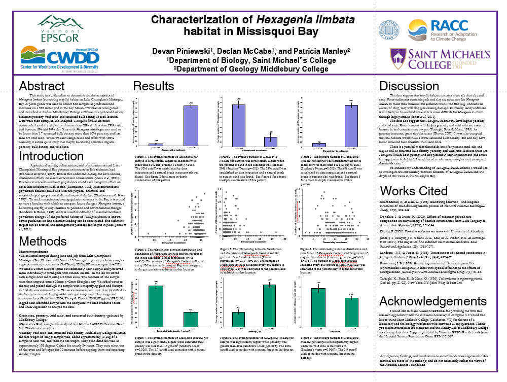
Characterization of Hexagenia limbata habitat in Missisquoi Bay
Devan Piniewski* (Saint Michael's College), Decan McCabe (Biology Department, Saint Michael's College), Patricia Manley (Department of Geology, Middlebury College)
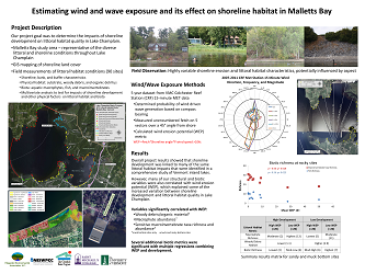
Estimating wind and wave exposure and the effect on shoreline habitat in Malletts Bay
Joe Bartlett, Fitzgerald Environmental Associates
Forest Transitions in An Agricultural Watershed? An Agent-Based Modelling Approach
Yushiou Tsai, UVM, EPSCoR, RACC
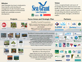
Lake Champlain Sea Grant
Elissa Schuett, UVM
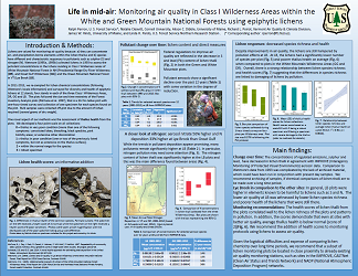
Life in mid-air: Monitoring air quality in Class I Wilderness Areas within the White and Green Mountain National Forests using epiphytic lichens
Ralph Perron, U. S. Forest Service*; Natalie Cleavitt, Cornell University; Alison C. Dibble, University of Maine; Richard L. Poirot, Vermont Air Quality & Climate Division; James W. Hinds, University of Maine; and Linda H. Pardo, U.S. Forest Service Northern Research Station .
Long Term Patterns in Stream Invertebrate Families in Addison County Streams
Vickie Backus, Alison Nurok and the Middlebury College Students of BIOL0140, Department of Biology, Middlebury College
Long-Term Monitoring of Surface Waters in Vermont: A 34 Year Partnership of Monitoring Remote Lakes and Upland Streams
Megan Euclide, State of Vermont, VTDEC - Monitoring, Assessment and Planning Program
Mercury bio-sentinels: student citizen scientists collect dragonfly larvae in national parks in Vermont, New Hampshire, and coast-to-coast
Kate L. Buckman, Dartmouth College
Mercury cycling in Vermont vernal pools
Vivien Taylor, Dartmouth College
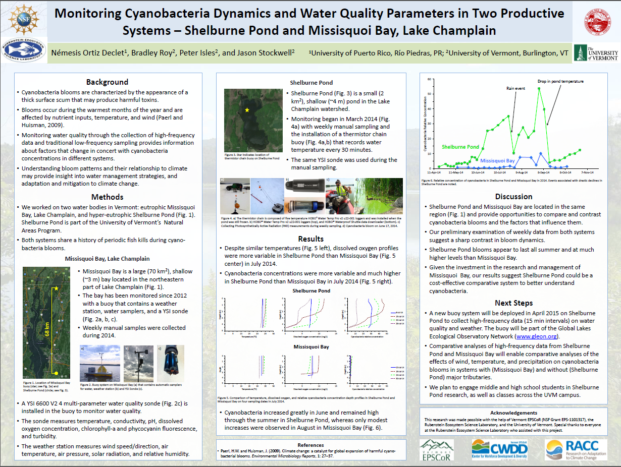
Monitoring Cyanobacteria Bloom Patterns and Water Quality in Two Productive Systems
Nemesis Ortiz Declet, Brad Roy, Peter Isles, and Jason Stockwell, University of Vermont
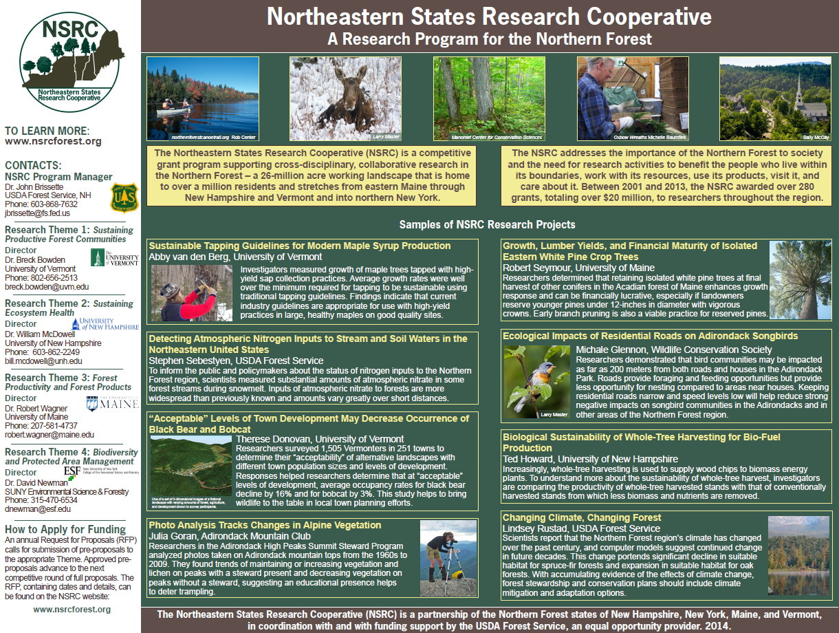
Northeastern States Research Cooperative
USDA Forest Service Northern Research Station, University of Vermont, University of New Hampshire, University of Maine, SUNY College of Environmental Science & Forestry, Northeastern States Research Cooperative
Seeing the forest for the trees: Summarizing multiple measurements for a comprehensive assessment of forest characteristics
Jennifer Pontius, UVM, USDA Forest Service, Northern Research Station
The Effect of Dreissena polymorpha on the Native Mussel Species in the Missisquoi Bay
Hannah Kittler, Saint Michael's College
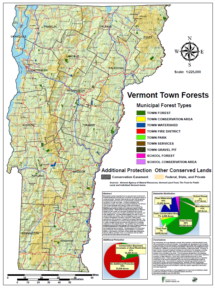
The Vermont Town Forest Database: An Inventory of Municipal Forestlands and their Uses
Sean MacFaden, University of Vermont