THE PROSPER VALLEY VIGNETTES:
In the Wake of Ice - Prosper Valley Surficial Geology

I had lived in Vermont for almost three years before I first realized why the Vermont forests had always felt so different from the Virginia forests of my youth. Flying out of Burlington Airport to visit my family for the Thanksgiving holiday, I was captivated by what, through the plane window, looked like pencil-drawn sketches all across the wooded hills bounding the Champlain Valley. As I focused my vision, the pencil-strokes turned into miles of stonewalls—exposed by the stark nakedness of winter. I had spent the past summer wandering the hills and hollows of the Prosper Valley and hardly a field day passed that I didn't hop across, or clamber over, half a dozen stonewalls. But, never before had the extent of Vermont's stonewalls been as apparent as it was that day from my airplane vantage.
Above Virginia's Blue Ridge Mountains, the only linear features visible from the tiny window of my puddle-jumping plane were streams, roads, and power lines. Where were the stonewalls? Maybe this one feature is why Vermont's forests have always felt different from Virginia's. Why is one place interlaced with stonewalls when the other has not a loose stone in sight? I don't think it was that the early Virginians never reduced their supply of trees for the construction of wood fences—as the early Vermonters had when they began relying on stones for fencing. And, I don't think it was because Virginians liked to plow rocky fields. Maybe they just didn't have rocky fields—but, why would that be?
I soon discovered that the striking difference between the two landscapes is partly attributable to a process occurring thousands of years ago—not to a difference in opinion between nineteenth century Virginians and Vermonters about what material constitutes a good fence. Around three million years ago the most recent ice age began, triggered by cooling climates and a buildup of snow. Glaciers form when the weight from snow buildup at high latitudes causes snow compaction into ice. Eventually, pressure from the weight of the ice causes it to radiate in all directions. Precipitation continually replenishes the ice pack atop these spreading centers and fuels further ice expansion, called a glacial "advance". During the last ice age, the most recent ice sheet to advance across North America was the Laurentide ice sheet. It originated in central Canada around 120,000 years ago and spread over central and eastern North America, resulting in a layer of ice at least one and a half miles thick above Vermont. During warm interludes, ice sheets melt faster than they advance, causing the glacier to "retreat". The Laurentide ice sheet reached its maximum southerly extent around Long Island roughly 25,000 years ago and retreated across Vermont between 16,000 and 13,000 years ago.
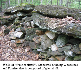
Thus, Virginia was out of reach of the Laurentide ice sheet. But how does that explain the absence of rocky fields? When most people think about glaciers and the effects they have on the land, they liken them to bulldozers, plowing across vast areas and tearing up everything in their path. Glaciers do sculpt the bedrock lying beneath them as they advance across the land. The characteristic, asymmetric shape of Camels Hump is one noticeable example. However, the bulldozing action by glaciers doesn't alone explain Vermont's rocky fields. Like a conveyer belt, glaciers pick up materials from one place and ultimately relocate them to another—close by or far away. Yes, on their advance, the glaciers reshaped the peaks and widened the valleys but, most significant to Vermont stonewalls, they picked up most everything loose that covered the bedrock. The glacier was like a molded jell-o salad, with boulders, rocks, sand, soil and trees inside rather than chunks of pineapple, cherries and pear. The explanation for Vermont's stony fields is in what the glacier left behind; as it melted and retreated from Vermont between 16,000 and 13,000 years ago, it left carpets of "fruit-cocktail" in its wake.
Now, this wouldn't have been appetizing fruit-cocktail—it would have been smashed to smithereens under the weight of the glacier. This heavily compacted glacial debris is what geologists call glacial till. Till is the most widespread surficial deposit—earth material deposited atop bedrock by glacial processes—in the Prosper Valley. As the ice sheet melted it left behind anything that had been enclosed by the ice. The result was a compact collection of rocks of different shapes, sizes, and origins plastered to the bedrock that lay beneath. Glacial till, first plucked off Vermont landforms during the glacier's advance and then spread haphazardly across the land during the retreat, is the source of stones in the quintessential Vermont stonewall.
And so, the reason for the lack of stonewalls in Virginia lies in the simple fact that it was beyond the reach of the last glacier, and therefore, not subject to glacial bulldozing or conveyer belt exploits. As you remove the annual crop of rocks from your Vermont garden this spring, imagine the massive glaciers that left behind those rocks. As I do, I will feel brethren to the strong, spirited person who struggled to survive on the land two centuries ago by heaving large stones from the earth and—sometimes artfully, sometimes not—creating a wall.