
151 South Prospect Street
Bittersweet
By Katharine Burns
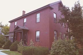 Ichabod Tuttle built this structure
at the intersection of South Prospect Street and Main Street in
1809. Originally intended as a trading post, it evidently became
his home as well. Tuttle's father, Thaddeus, left Grasse Mount
to spend his later years in his son's home (1). Margaret Smith bought the property in 1928,
and resided there until her death in 1961.
Ichabod Tuttle built this structure
at the intersection of South Prospect Street and Main Street in
1809. Originally intended as a trading post, it evidently became
his home as well. Tuttle's father, Thaddeus, left Grasse Mount
to spend his later years in his son's home (1). Margaret Smith bought the property in 1928,
and resided there until her death in 1961.
Smith bestowed the name Bittersweet on the house in honor of her late husband, who had perished in an automobile accident in 1918. When they had settled into their farmhouse on Spear Street, she recalled the following story: "Bittersweet grew all over the place and my husband, who was a Southerner, named it after that vine, saying, "Maybe it will be bitter, but maybe it will be sweet; it depends on whether the Yankees like me or whether they don't"(2).
Smith also revealed that it was after her husband's accident
that she become involved with the real estate business, a venture
she continued at the South Prospect residence.
She opened the Bittersweet tea room immediately upon moving in,
but closed it shortly thereafter to concentrate her energies on
a real estate office under the name The Bittersweet Agency. She
operated the latter establishment until she turned 85 in 1852.
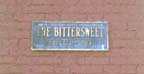
Smith sold her property to UVM in 1940, but retained the right
of lifelong residence. In 1951, she erected a bronze plaque that
read "1804" as a reference to her farmhouse on Bittersweet
(see below right). Currently, the UVM Environmental Program is
housed at the site.
The majority of the alterations to Bittersweet have been in the form of porch additions or entrance elaboration, much like the Benedict House. A wooden Queen Anne addition was placed on the south façade in the late 1800s, complete with dormers. The bay window to the left of the main door was also added at this time. A two-story wooden porch occupies the rear of the house, and the Colonial Revival entrance is estimated as a 1920s alteration. The house's current color scheme of red and black resulted from a 1999 restoration effort (3).
The 1830 Ammi B. Young map shows a structure opposite Bittersweet, in the lot where the Allen house now stands. The Allen House is commonly dated at1838, but there is a remote possibility that it is the structure shown by Young. However, the footprint on the Young map differs substantially from the structure shown in the 1857 Wallings map, thus supporting the contention that the Allen house replaced the building shown on the Young map (4).
Sources |
| (1) David Blow, Historic Guide to Burlington Neighborhoods (Burlington: Chittenden County Historical Society, 1978), 173. |
| (2) Ibid., 174. |
|
(3) National Register of Historic Places. Unites States Department of the Interior, National Park Service. (4) See Ammi B. Young, Plan of Burlington Village, 1830 (Special Collections, University of Vermont Library, Burlington, Vermont); Wallings Map, Chittenden County, 1857. |
Introduction | 1830 Young map | 1830-1988 overlay maps | Street index | Surviving 1830 buildings | UVM Historic Preservation Program