
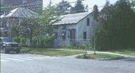
 30-32 North Champalin Street
By Keats Gallagher
On the 1830 Young map, there are only ten structures on the
entire stretch of North Street, from North Avenue to North Prospect
Street. Add to that another ten on the section of North Champlain
Street in question, and we can see that this part of the city
was probably still quite rural.Understanding this, we should consider
the possibility that some of these structures may have been agricultural
outbuildings. There is actually a good deal of corroboration that
in 1830 the area of North Street was rural and removed from the
main part of Burlington.(1) The clearest
statement on this topic comes from W.S. Rann in his History of
Chittenden County, VT. : "In 1827, there were not more than
a half dozen houses north of Pearl. The only street beyond Pearl
was North Avenue, which was inhabited chiefly by colored people
in shanties" (2)
Nonetheless, there does seem to have been considerable development
activity in the lower portion of the neighborhood (North Champlain
Street), and most of that was probably connected to The Champlain
Glass Company which opened in 1827. The map shows three buildings
on the west side of Champlain Street. and two on the east side.
We know that the complex of the Glass Works is "said to have
been composed of about a dozen buildings located near the north-east
corner of Park and Sherman Streets" (3)
Also, land records may support the thesis that the present
day 30-32 North Champlain Street contains elements of at least
one structure from the Young map.
Land records from 1829 refer to a 1/4-acre site near the Glass
Works on the east side of Champlain Street.. The transfer in question
was a deed from Luke Thompson to John Peck, and it involved the
land "along with the south half of the house now standing
on the land... also a piece of land for a wheelwright shop on
the west side of Champlain Street"(4).
An archeological survey of the site, conducted in 1995, places
the wheelhouse approximately where Monroe Street now goes east
from North Champlain- a valid description of the property in question
(5). Despite the confusing descriptions,
there is fairly consistent mention of a house -possibly a double
house- on this land. The present 30-32 North Champlain Street
(this house has been substantially altered) may well contain the
core of either the shop or house referred to. The Vermont Historic
Sites and Structures Survey of 1996 concurs that this house is
the one on the Young map, and indeed, footprint correlations through
the years do appear consistent.
Notes
| 1 | William Rann. History of Chittenden County, Vermont. (Syracuse: D. Mason and Co. 1886), 424. and University of Vermont, Historic Preservation Program. North Street Historic District. (online). Burlington, Vt. Available from the World Wide Web. (http//www.uvm.edu/~histpres/HPJ/NR/northstreet/nssig.html) |
| 2 | William Rann. History of Chittenden County, Vermont. (Syracuse: D. Mason and Co. 1886), 424. |
| 3 | David Blow. Historic Guide to Burlington Neighborhoods. (Burlington, VT. : Chittenden County Historical Society.1991), 2. |
| 4 | Prudence Doherty & Kathleen Kenny. Archeological Sensitivity Study for 25-31 North Champlain Street, Burlington, VT. (Burlington, VT; Consulting Archeology Program, University of Vermont. 1995), 9. |
| 5 | Doherty et al., 9. |
Sources
Blow, David. Historic Guide to Burlington Neighborhoods. Burlington, VT.: Chittenden County Historical Society,1991.
Doherty, Prudence & Kathleen Kenny. Archeological Sensitivity Study for 25-31 North Champlain Street, Burlington, Vermont. Burlington, VT., Consulting Archeology Program, University of Vermont, 1995.
Rann, William. History of Chittenden County, Vermont. Syracuse: D. Mason and Co., 1886.
University of Vermont , Historic Preservation Program. North
Street Historic District.(online). Burlington, VT.. Available
from the World Wide Web.
(http//www.uvm.edu/~histpres/HPJ/NR/northstreet/nssig.html)
Vermont Division for Historic Preservation. Historic Sites & Structures Survey, Burlington. 1978. Collection on file at Planning and Zoning Department, City of Burlington, VT.
Maps
Presdee & Edwards. Map of Burlington, VT. 1853.
Sanborn Fire Insurance Maps, Burlington, VT. 1850-1978.
Young, Ammi B. Plan of Burlington Village. 1830. Special Collections,
University of Vermont Library, Burlington, VT.
Introduction | 1830 Young map | 1830-1988 overlay maps | Street index | Surviving 1830 buildings | UVM Historic Preservation Program