 Boundary Description
Boundary Description
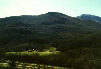
The property being nominated for the Preston-Lafreniere farm, Bolton, Chittenden County, Vermont, is a +/_ 60 acre parcel of land including a c. 1830 Classic Cottage, c. 1810-30 English style barn, and a c. 1810-30 English style barn with an attached c. 1850 shed and a c. 1940 ground level stable barn surrounded by hay fields and forested hills. Since the farmstead contributes to the understanding of the development of Vermont's Agricultural History, and for its preserved architectural styles of agricultural buildings, the open farm fields and the surrounding wood lots are also significant components of the history of the farmstead. Although the farm is no longer in operation, the hay fields annually produce three cuts of hay and the barns are utilized by local farmers for hay and machinery storage. Similar to many of Vermont's rural areas, the Preston-Lafreniere property was never surveyed, so natural features and the U.S. Geological Survey Maps were utilized to define the National Registry boundaries.
Beginning at the southwest junction of the Preston Brook and the Winooski River (Point A), the property traverses in a westward direction along the southern edge of the Winooski River approximately 2,250 feet to a point where the bank of the Winooski River meets Bolton Town Highway 1 (Duxbury Road) (Point B). The boundary then rises from the river, across Duxbury Road and traverses along the tree line for approximately 3,750 feet in a southeast direction to a point where the c. 1870 saw mill foundation meets the Preston Brook. The boundary turns in a northerly direction at the southeast corner of the saw mill foundation and runs approximately 2,650 feet along the Preston Brook back to point A.
Boundary Justification
The boundary includes all the buildings and surrounding open fields historically associated with the Preston-Lafreniere Farm and possible (unexcavated) historic/pre-historic archeological remains.