Main History
Maps
Photos Agricultural Census
Resources |
| Agricultural History of Richmond, Vermont
Paul Wackrow, 2009
Early History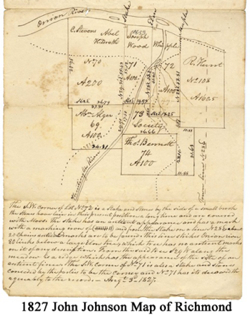
The town of Richmond has always had a close connection to its
surroundings. Situated on the Winooski River, is situated between
Montpelier and Burlington, only ten miles east of Lake Champlain.
Indeed, Richmond is one of the only towns in Chittenden County not
originally chartered by the state of New Hampshire, being formed from
parts of Jericho, Bolton, Huntington, and Williston in 1794.[1] Amos
Brownson and John Chamberlain first attempted settlement in Richmond in
1775, but soon abandoned the effort.[2] A second effort was made in the
mid 1780s, and town boundaries were being recorded by 1791, three years
before Richmond was chartered. The specifications and boundaries were
recorded by John Johnson, who wrote, “Beginning at a certain point of
Rocks on onion River, being a little above Bradley Bond(so called).
From Thence a straight line until it intersects the town line between
Jericho at the 3 mile mark.”[3] Johnson goes on to state that 300 acres
are laid out to John Brush in the southeast corner of town. By the
1820s Richmond’s population was over 1,000.[4] A 1827 Johnson map of
the Jonesville section of Richmond shows land plots near the Huntington
and Winooski rivers for a number of farmers, including a 200 acre
parcel belonging to Abel Hildreth. [5]
Richmond Agricultural Data
The earliest agricultural census data for Richmond came in 1840. This
early census only looked at broad numbers for the entire town, and left
out information about individual farms and property owners. While the
1840 census contains less information than later editions, the
statistical information is vitally important. Richmond contained 281
horses & mules, 3311 cattle, poultry estimated at 611, 1,941
bushels of wheat and 7,864 bushels of Indian corn.[6] A tabulations of
town totals from 1860 yields noticeable results in relation to 1840.
While the number of horses is relatively similar, and cattle are
calculated differently, the bushels of Indian corn produced rose from
7,864 to 16,777.[7] The 1860 agricultural Census also contained data on
the value of livestock, the value of the entire farm, butter
production, and cheese production. The information from 1880 indicates
the beginnings of a turn away from agriculture. The total acreage of
agriculture land is down, and the value of
farm land
has grown only slightly from $588,700 in 1860 to $655,800 in 1880. The
value of livestock dropped about $10,000 to $85,018 and the number
of horses remained under 200. Butter production increased, while cheese
production fell.[8] The Bureau of the Census also conducted research
in 1945 in the form of unpublished data. In this report it was
indicated that there were sixty-four farms in Richmond, down from over
100 in 1880. At 3,918 acres, harvested cropland was about half of what
it was in 1880.[9]
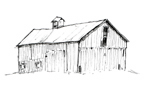
Farms of Richmond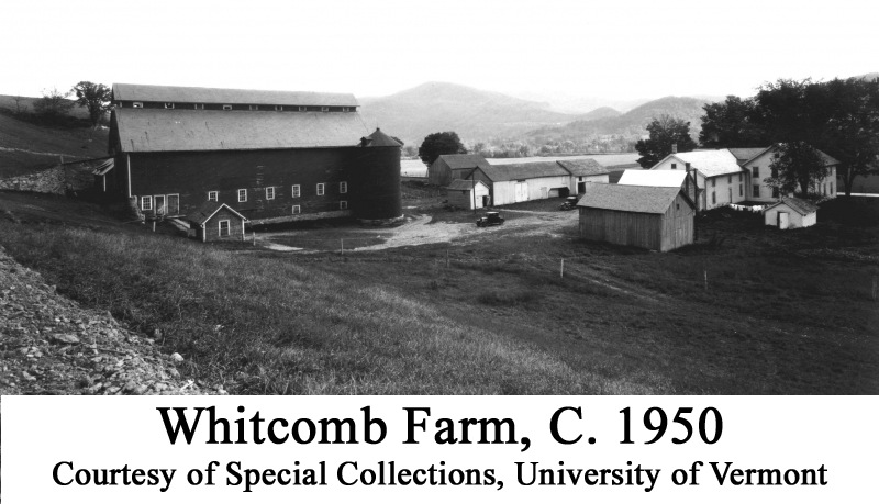
Appearing on both the 1857 Wallings Map, and the 1869 Beers Map The
farms of the Whitcomb brothers are among the most prominent in
Richmond. Indeed the east farmstead holds special significance for
Vermonters in being the birthplace of Senator Edmunds.[10] Indeed, the
1880 Agricultural Census lists U.S. Whitcomb’s farm as the most
valuable in town at $40,000, and the second largest in relation to
tilled land. The value of livestock on U.S. Whitcomb’s farm in 1880 was
twice that of any other farm in Richmond at $6000. The Whitcomb
brothers’ farm featured two large high-drive monitor barns, built in
1903, which still exist today. While the eastern barn has always stood
set back from the road, the western monitor once stood much closer
to the road until a recent rennovation campaign saw it moved back o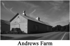 n
the property.[11] In addition to the monitor barn, the property is contains
a number of earlier farm buildings, as well as a round roof metal barn
dating from the 1970s. n
the property.[11] In addition to the monitor barn, the property is contains
a number of earlier farm buildings, as well as a round roof metal barn
dating from the 1970s.
The
Andrews Farm on Route 2 also retains its historic barn structure and
function. Asa Rhodes purchased the property in 1814, and the
property is on both the Wallings and Beers maps. The barn was barns
were originally constructed in the 19th century and joined together in
1917.[12 & 13] The property also features a number of agricultural
outbuildings, including and ice house, shed, and butcher shop.
Later Developments
Between access to the Winooski River and the introduction of the
railway, Richmond has always been associated with transportation.
However, the plan for an interstate highway to cut straight
through the town in the late 1950s was a completely new concept.
Reactions to the plan varied all across the state. In the 1960
pamphlet “Superhighway in Vermont? Necessity or Extravagance?” Herbert
Ogden writes, “A disastrous side-effect of the coming of a superhighway
(assuming it will draw industry and population as advertised) is that
many resident along its path will have to move out of town (if it does
not draw that industry and population there is no need for it in the
first place).”[14] While there was certainly opposition, the people of
Richmond, by all accounts, seemed to support the building of
I-89. A 1960 Burlington Free Press piece by Joe Heaney indicates
that many residents of Richmond were looking forward to the changes
that Ogden feared. Heaney writes “An opinion poll here Friday brought
this consensus: it (the interstate) will only hurt for a little while
because local growth will offset transient business loss.”[15] The
biggest fears in Richmond seemed to relate to restaurant owners who
depended on commuter traffic, and the effects of eminent domain on
farmland do feature as a serious concern. This is reiterated in the
Free Press article, “Landowners Don’t Object” reporting a public
hearing on the transfer of land holdings from February of 1960. The
piece states, “No objections were voiced by property owners or their
lawyers to the land acquisitions by the Highway Department, but
Selectman Sumner Farr of Richmond entered an objection to the proposed
design of an overpass bridge over Town Route 8 in Richmond.”[16] While
the interstate has changed the face of Richmond, it has not destroyed
the rich agricultural character of the town.
[1] Hamilton Child, Gazetteer and Business Directory for Chittenden
Country, Vermont, for 1882-1883. (Syracuse: Hamilton Child, 1882-1883),
249.
[2] Ibid. , 250.
[3] John Johnson, “Richmond specifications of boundaries 1791,” John
Johnson Collection, Special Collections, Bailey-Howe Library,
University of Vermont, Burlington.
[4] United States Census data for Richmond, VT in Richmond, Vermont: A
History of over 200 Years ed. Harriet Wheatley Riggs (Richmond:
Richmond Historical Society, 2007), Appendix D.
[5]John Johnson, “Richmond August 3, 1827” John Johnson Collection,
Special Collections, Bailey-Howe Library, University of Vermont,
Burlington.
[6] U.S.
Census of Mines, Agriculture, Commerce, Manufactures: 1840., Schedule
No. 10.
[7] U.S. Census
of Agriculture 1840., Schedule 4-Productions of Agriculture in Richmond
in the County of Chittenden, 9-14
[8] U.S. Census of Agriculture 1840., Schedule 2-Productions of
Agriculture in Richmond in the County of Chittenden, Vermont, 1-10.
[9] Farm Census for the Towns of Chittenden County Vermont. Based on
Unpublished Data furnished by the bureau of the census.
[10] State of Vermont. “Historic Sites and Structures Survey” Vermont
Division of Historic Preservation. 6-15-76, Survey no. 0411-26.
[11] Ibid.
[12] State of Vermont. “Historic Sites and Structures Survey” Vermont
Division of Historic Preservation. 6-15-76, Survey no. 0411-25.
[13] Ibid.
[14] Herbert Ogden. “Superhighway in Vermont? Necessity of
Extravagance?” (Hartland, Vermont: Herbert Ogden, 1960), 5.
[15] Burlington Free Press (Burlington), 27 January 1960.
[16] Burlington Free Press (Burlington), 24 February 1960.
Bibliography
Child, Hamilton, Gazetteer and Business
Directory for Chittenden Country, Vermont, for 1882-1883. (Syracuse:
Hamilton Child, 1882-1883), 249.
Johnson, John. “Richmond
specifications of boundaries 1791,” John Johnson Collection, Special
Collections, Bailey-Howe Library, University of Vermont, Burlington.
Johnson,
John. “Richmond specifications of boundaries 1791,” John Johnson
Collection, Special Collections, Bailey-Howe Library, University of
Vermont, Burlington.
Farm Census for the Towns of Chittenden County Vermont. Based on Unpublished Data furnished by the bureau of the census.
State
of Vermont. “Historic Sites and Structures Survey” Vermont Division of
Historic Preservation. 6-15-76, Survey no. 0411-25 and 0411-26
United
States Census data for Richmond, VT in Richmond, Vermont: A History of
over 200 Years. ed. Harriet Wheatley Riggs (Richmond: Richmond
Historical Society, 2007), Appendix D. |
|