This photograph shows the paving of Flynn Avenue and the tricky method of paving around railroad tracks without covering them completely and thus rendering them useless. The most prominent structure in this photo is number 194 Flynn Avenue, a shingle-style home with several gabled peaks. The original resident in this structure was Oscar F. Tucker; and he remained there through the time period that this photo was taken in 1931.(1) Sometime between 1942 and 1960 this structure was removed.(2) The last listed resident at this address appeared in the 1946 city directories, so it can be assumed that the building was removed sometime in this time period, probably in order to make way for more industrial purposes that were better aligned with Ferguson and Scarff’s plan for The Addition.(3)
In the right of the photo one can see the corner of number 207 Flynn Avenue, which is actually the first in a series of three buildings that run north from that point perpendicular to Flynn Avenue, all addressed as number 207. As the first inhabitants of the space, coming in 1919, the Vermont Milk Chocolate Company remained in the buildings until 1943.(4) By looking at the Sanborn maps for the time period, one can see how the space needed and used by the company waxed and waned, probably depending on how business was. The United Maple Syrup Company and the Everpure Ice Corporation appeared in 1931, the year this photo was taken. These were the three largest companies to use this complex prior to and for a long while after 1931.
(1) Manning's Burlington & Winooski Directory for years 1923-1931 (Springfield H.A. Manning Co).
(2) Insurance Map of Burlington, VT (New York: Sanborn Map Company, 1942, 1960).
(3) Insurance Map of Burlington, VT (New York: Sanborn Map Company, 1942, 1960).
(4) Manning's Burlington & Winooski Directory for years 1919-1943 (Springfield H.A. Manning Co).
|
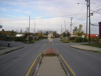
Ferguson and Scarff’s plans to use the four blocks bordering the railroad tracks as industrial space was never fully realized, at least during their lifetimes. Today, the southeast parcel of land (left in the photo) does have a business using the land, but it does not show up on the most recent Sanborn Map, produced in 1970, or any prior maps.(1) Flynn Avenue Self-Storage is now located to the west of this plot.
The lot on the right, where the 194 Flynn Avenue had been, is currently vacant and has remained so since the structure was removed. The large red-roofed industrial-looking building in the background is number 180 Flynn Avenue, and is relatively new, as well.(1) Today it houses the Switchback Brewing Company and McKenzie Specialty Meat Company.
More signage to denote the location of the still-functioning railroad tracks has also been added. With these additions, the area maintains its industrial purpose and feel.
(1) Insurance Map of Burlington, VT (New York: Sanborn Map Company, 1895-1970).
(2) Insurance Map of Burlington, VT (New York: Sanborn Map Company, 1970). |