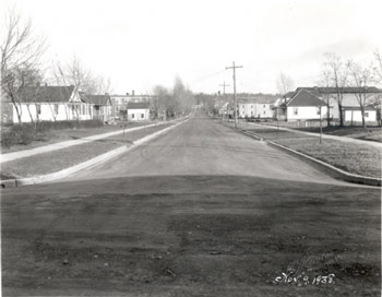
Ferguson Avenue runs the west from Shelburne Road and concludes at the intersection of Briggs Street in the west. Seen in the distance on the north side of the street (left) is Saint Anthony’s Roman Catholic School, opening in 1931. This was a large 3-story brick block-like building with large windows. Sanborn maps identify the school building as a combination building, serving as both a school and a convent. (1)
Saint Anthony’s Roman Catholic Church was opening in 1902 as a French-speaking neighborhood parish, meant to serve the large influx of French Canadian immigrants in the Ferguson & Scarff Addition. (2)
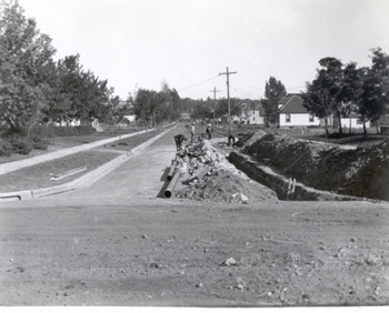
The photograph shows the sewer system being enlarged and extended as part of the city of Burlington’s plan to improve the Ferguson & Scarff Addition. The city was confident that, “with these added improvements … there will undoubtedly be an increasing demand for the sale of building lots and the erection of moderate priced homes.” (3)
The small hipped-roof house on the south side of the street (right) is number 27 Ferguson Avenue. In 1930, when the address first appears in the city directory, it was home to Adelard J. Charest, employed with the Edlund Company. At the time of the photo in 1938, the same gentleman and corresponding occupation were listed. Closer to the photographer but set back off the street was Fire Station No. 5. In the 1923 city directory, this lot (#23 Ferguson Avenue) was listed as “firehouse under construction.” (4)
(1)
Insurance Map of Burlington, VT (New York: Sanborn Map Company, 1919);
Manning's Burlington & Winooski Directory for year 1932 (Springfield H.A. Manning Co).
(2)
Manning's Burlington & Winooski Directory for year 1932 (Springfield H.A. Manning Co).
(3) 73rd Report of the City of Burlington, Vermont 1938 (Burlington: Free Press Printing Co.), p169.
(4) Manning's Burlington & Winooski Directory for year 1923 (Springfield H.A. Manning Co).
|
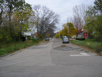
Currently, Ferguson Avenue is still mainly a residential street. Saint Anthony’s parish school was closed in 1971 and the building was removed sometime before 1978. (1) Notice the growth of the trees that would impede the view of the building even if was still standing on that site.
The hipped-roof house at number 27 is still there, and the lot at #23 still contains a fire-station, albeit a new one built in 1991,(2) not the original 1923 station.
At some point, the street was widened at this end and the loss of the sidewalks translates dramatically into a much different streetscape. The houses no longer have much frontage between the doorsteps and the street. The overgrowth of brushes and trees in the place of the sidewalks gives the street a decidedly different feel.
(1) Insurance Map of Burlington, VT (New York: Sanborn Map Company, 1978); Manning's Burlington & Winooski Directory for year 1972 (Springfield H.A. Manning Co).
(2) Cornerstone, 27 Ferguson Avenue (2006). |