
|
 |
 |
70 South Winooski Avenue A view of the intersection of South Winooski Avenue and Bank Street looking north shows the character-defining features of the landscape during 1936. South Winooski Avenue is a wide expanse of pavement, appearing to accommodate two lanes of through traffic with on-street parking along the west and east sides of the street. The pavement looks rough, seemingly patched together multiple times with asphalt, creating a patchwork arrangement on the ground plane. Tall and arched branches of American elm trees frame views down the street corridor and provide a shady residential atmosphere. Overhead utility poles, lamp posts and concrete sidewalks line the edges of the street. The most prominent building in the photograph is 70-72 South Winooski, located along the east (right) side of the street. This building was likely built during the mid 1850s(1). This two story, six bay, gable-roofed frame with brick veneer building is predominantly constructed in the Federal style with two small covered porticos centered on the main façade. The two central doors hint to the fact that the building is a duplex, which is confirmed by the 1935 Sanborn Map(2). In 1869, D. Kern is listed as the property owner of 70-72 South Winooski(3). At the turn of the century, the building partially remained in the Kern family, as Mrs. Sophia C. Kern resided in 72 South Winooski, while Charles R. Kempter occupied 70 South Winooski(4). By 1931, Mrs. Sophia C. Kern continued to live in #72, and Edward R Hutchinson resided in #70(5). By 1942, however, the building housed two new residents— Alba C. Booth and Mary E. Pease(6). For more information about the Kern house, please click here. Other structures seen in the photograph include the 1st Congregational Church, the 1st Methodist Church and the partial facades of two residential houses along the west side of the street. Back to Depression Era Streetscapes.
(1) Vermont Division for Historic Preservation. Vermont Historic Sites and Structures Survey. Pearl Street. Montpelier, Vt. Division for Historic Preservation, n.d. (2) Sanborn-Perris Map. Burlington, Vermont 1926 with 1935 updates. (3) Beers Map of Burlington, Vermont 1869 (4) Burlington City Directory, 1901 (Burlington: H. A. Manning Co., 1916-1986). (5) Burlington City Directory, 1931 (Burlington: H. A. Manning Co., 1916-1986). (6) Burlington City Directory, 1942 (Burlington: H. A. Manning Co., 1916-1986). |
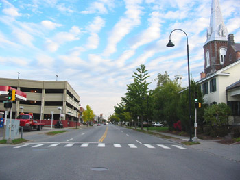
70 South Winooski Avenue Today the character of the intersection of South Winooski Avenue and Bank Street has changed. Residential buildings along the west edge of the street have been removed and replaced with a gas station and modern concrete parking ramp. The parking ramp was funded with $1.6 million in January 1979 by the Economic Development Administration to create additional parking spaces for the urban renewal redevelopment projects at that time(1). The ramp provides an additional 400 parking spaces for the downtown business district and the Church Street Marketplace(2). The addition of new buildings and features and the loss of historic landscape features, including tree canopy, utility lines, and historic street lights also change the character of the street. The buildings along the eastern side of the street are extant today, including 70-72 South Winooski, the 1st Congregational Church, and the 1st Methodist Church. 70-72 South Winooski remained occupied throughout the mid-20th century. In 1972, occupants included Richard Conklin, dentist, Robert Perrin, dentist, Theod Zolotas, Brian Marshall, Josh Brady, and one vacancy(3). Currently , the property is occupied by the UPS Store and is listed on the National Register of Historic Places. Mature plantings to the west of the building partially screen the building from view. Back to Depression Era Streetscapes.
(1) A History of the Church Street Marketplace. www.churchstmarketplace.com/history.html 3 November 2006. (2) A History of the Church Street Marketplace. www.churchstmarketplace.com/history.html 3 November 2006. (3) Burlington City Directory, 1972 (Burlington: H. A. Manning Co., 1916-1986). |
Historic Burlington Project Depression Era Streetscapes: Old North End | Burlington 1890 | Burlington 1877 | Burlington 1869 | Burlington 1853 | Burlington 1830 Produced by University of Vermont Historic Preservation Program graduate students in HP 206 Researching Historic Structures and Sites - Prof. Thomas Visser - in collaboration with UVM Landscape Change Program Historic images courtesy of University of Vermont Library Special Collections, Louis L. McAllister Photograph Collection |