
|
 |
 |
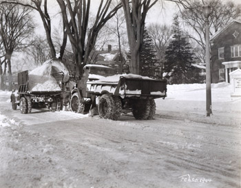
38 South Winooski Avenue During the winter of 1944, near record amounts of snow fell on the city of Burlington. McAllister, interested in recording different methods of snow removal, took this photograph showing one method of snow removal used to by the Burlington City Streets Department. The caption reads, “This view shows the Snow King Rotary snow loader mounted on Walter Snow Fighter truck loading snow from the street into a 10 cubic yard truck body. One of these truck loads is loaded in approximately ¾ of a minute. An average fall of 6 inches of snow will require the hauling of approximately 250 loads of snow from business streets.” This McAllister photograph also shows the chapel of the 1st Congregational Church complex along the east side of South Winooski Avenue. The building is a two story, three bay, brick block with a gable roof. Windows are 18-over-18 and are arranged symmetrically on the front façade of the building. An oculus window in the gable peak and small white portico also characterize the building. The chapel is part of several additions that were added to the church since its erection in the 1840s. In the 1930s, the chapel was connected to the church through another series of additions that linked the two buildings together(1). A white gable-peaked sign appears in front of the chapel, listing the acting reverend and the times of church services. The adjacent landscape contains several deciduous and evergreen trees. A single light post is also shown in the foreground along the street, topped with a lantern light fixture. Back to Depression Era Streetscapes.
(1) Blow, David. Historic Guide to Burlington Neighborhoods, Vol. 1 (Chittenden County Historical Society, 2003). |
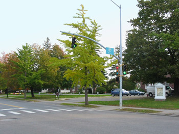
38 South Winooski Avenue Today the chapel remains part of the 1st Congregational Church complex, but is screened from view by young and dense deciduous trees. Though large American elm trees were lost and removed over the past decades, new trees were planted in their place. A small parking lot has been added to the west side of the chapel, immediately in front of the main façade. The white church sign remains in the landscape over 60 years later. South Winooski Street also appears similar in character. Noticeable changes include the addition of modern street lights, traffic lights, and signage at the intersection. Back to Depression Era Streetscapes.
|
Historic Burlington Project Depression Era Streetscapes: Old North End | Burlington 1890 | Burlington 1877 | Burlington 1869 | Burlington 1853 | Burlington 1830 Produced by University of Vermont Historic Preservation Program graduate students in HP 206 Researching Historic Structures and Sites - Prof. Thomas Visser - in collaboration with UVM Landscape Change Program Historic images courtesy of University of Vermont Library Special Collections, Louis L. McAllister Photograph Collection |