
|
 |
 |
16 South Winooski Avenue, This McAllister photograph, taken on July 3, 1934 shows the repaving of South Winooski Avenue. Several workers are shown in the background laying and spreading the asphalt, with a steam roller to the left and many construction flags on the right. The caption reads, “P.W.A. Project #2232. A view of the South Winooski Avenue surfacing project looking northerly near its intersection with Pearl Street. The binder course is here shown in process of application. Note rough and uneven condition of old surface.” More detail is given about the South Winooski Avenue paving project in the 1931 city report. The report discusses the project as follows: This job is divided into two sections A). Main Street to College Street where the pavement was widened on the westerly side a width of five feet and paved with seven inches of concrete. A new concrete curb was also constructed on this section. B). From College Street to Pearl Street. On this section the old stone curbs and gutters were removed on both sides of the street, the street widened five feet on either side and new concrete integral curbs and gutters constructed. A new pavement was constructed on the entire area of the street consisting of a stone base obtained from the salvaged cobble stone gutters and stone curbing. On this stone base was constructed approximately two and one half inches of asphalt hot-mix binder. This binder course was finished two inches in thickness to be constructed next year over the entire pavement area. This method of construction allows the full use of the old pavement as a base on which a new wearing surface can be constructed at a very minimal unit cost, thus salvaging all of the value which had previously been put into the construction of the old pavement. It was necessary to remove about fifteen shade trees along the sides of this project in order to widen the pavement to the proposed width. The electric light poles also had to be reset on the westerly side of the Street. The total cost of this job, including all new curbs and gutters, pavement, removal of trees and all labor and materials in connection with the complete job, was $7176.98. The cost of the paving alone was $2,068.10. The total area paved was 1318 square yards, making a unit cost of one dollar and fifty-seven cents ($1.57) per square yard. This was a much needed improvement and has helped considerably to solve the traffic and parking problems in that section of the business streets(1). The McAllister photograph also gives insight to the character of the street during the 1930s. Overhead utility lines run along the west (left) side of the street. To the east (right) are three large American elms (Ulmus americana) lining the street and adjacent sidewalk. A decorative cast iron fence lines Pearl Street just north of the elms. The elms and fence are located at 16 South Winooski Avenue, which was occupied by Rev Charles S Jones, of the 1st Congregational Church, who continued to reside there through the 1940s(2). Historically, the property belonged to the 1st Congregational Church in 1830, and was used as the “Church Green” in 1869(3). Two buildings are shown lining the west (left) side of the street. In the foreground is 11-13 South Winooski, with 7 South Winooski farther north. In the background of the image, several buildings line North Winooski Avenue and Pearl Street. For more information pertaining to the buildings shown along North Winooski Avenue and Pearl Street please click here. 11-13 SOUTH WINOOSKI AVENUE The building located at 11-13 South Winooski is a two story brick garage with steel trusses, plastered walls, and concrete floor(4). The floorplan of the building contains an office, large entryway, auto supply room, and large garage with a capacity for 60 cars(5). Four gasoline tanks are located in front of the building along the street, suggesting that the building also serves as a gas station(6). A Shell sign and AAA sign on the front facade confirm the building is a gas station. In 1931, Yandow Garage was listed as the occupant of the building in the Burlington City Directory(7). Yandow Garage continued to occupy the building in 1942, though the business name had changed to Yandow Tire & Battery Company(8). The building layout and use slightly changed during this time too, to include auto sales and service in the rear and tire sales in the front half of the building(9). The four gas tanks remained along the South Winooski Avenue in 1942. 7 SOUTH WINOOSKI AVENUE 7 South Winooski is a 1-1/2 story frame building with a two story frame porch to the east. The main block of the building is rectangular sided with wood clapboards with a gable roof and brick chimney. The side porch is a saltbox-type addition with square posts. A tall stone wall encompasses the rear of the building, presumably for storage, and large sign on the wall says “Monumental Works.” In 1931, the Carl D. Densmore Company, Inc. monument company occupied the site(10). By 1942, the building had been demolished and replaced with a small, one story cinder block gas station with a concrete floor, with two gas tanks to the north(11). As a result, the address of the property changed from South Winooski to Pearl Street. The Shell Oil Company Station was the tenant of the building during this time(12). Historically, there was a building present at the corner of South Winooski Avenue and Pearl Street since 1830. The structure remained on the property throughout the 19th century, was owned by Dr. S. Waper in 1869, but was destroyed some time prior to 1901(13). In 1901 the lot remained vacant. Back to Depression Era Streetscapes.
(1) Report of City of Burlington, Vermont, 1931; 216. (2) Burlington City Directory, 1931, 1942 (Burlington: H. A. Manning Co., 1916-1986). (3) A.B.Young Map. Burlington, Vermont 1830; Beers Map of Burlington, Vermont 1869. (4) Sanborn-Perris Map. Burlington, Vermont 1926 with 1935 updates. (5) Sanborn-Perris Map. Burlington, Vermont 1926 with 1935 updates. (6) Sanborn-Perris Map. Burlington, Vermont 1926 with 1935 updates. (7) Burlington City Directory, 1931 (Burlington: H. A. Manning Co., 1916-1986). (8) Burlington City Directory, 1942 (Burlington: H. A. Manning Co., 1916-1986). (9) Sanborn-Perris Map. Burlington, Vermont 1942. (10) Burlington City Directory, 1931 (Burlington: H. A. Manning Co., 1916-1986). (11) Sanborn-Perris Map. Burlington, Vermont 1942. (12) Sanborn-Perris Map. Burlington, Vermont 1942. (13) A.B.Young Map. Burlington, Vermont 1830; Beers Map of Burlington, Vermont 1869; Burlington City Directory, 1931 (Burlington: H. A. Manning Co., 1916-1986). |
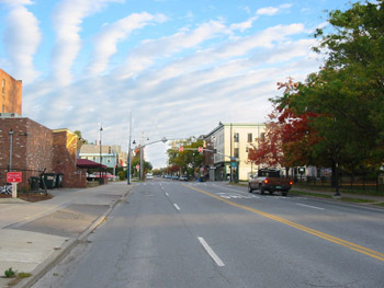
16 South Winooski Avenue, Today, South Winooski Avenue retains some of its features from earlier decades, though many elements have changed. The street utilizes the on-street parking areas from the 1930s as to create a four-lane street for through traffic. The street may have been additionally widened at some point during the mid to late 20th century. The American elms on the property at 16 South Winooski have been lost and removed, but other deciduous trees have been replanted in their place, maintaining the density of vegetation along the east side of the street. Other losses of significant landscape features including buildings at 7 South Winooski and 11-13 South Winooski along the west side of the street create an open expanse. Modern traffic lights, signage, and street signs have also been added to the streetscape; these small-scale elements additionally change the character of the street. Throughout the 1940s, the Shell Oil Company Station remained at the corner of Pearl Street and South Winooski Avenue. By 1972, the name of the gas station changed to Bob’s Shell Service(1). During the late 20th century, the gas station was demolished and a blocky, angular brick building was constructed in its location. Today, Asiana House occupies the site. Similarly, the Yandow Garage located at 11-13 South Winooski was demolished prior to 1971(2). The site of the former building is now part of Asiana House, an adjacent alley, and parking lot for Brooks Pharmacy. Back to Depression Era Streetscapes.
(1) Burlington City Directory, 1972 (Burlington: H. A. Manning Co., 1916-1986). (2) Burlington City Directory, 1972 (Burlington: H. A. Manning Co., 1916-1986). |
Historic Burlington Project Depression Era Streetscapes: Old North End | Burlington 1890 | Burlington 1877 | Burlington 1869 | Burlington 1853 | Burlington 1830 Produced by University of Vermont Historic Preservation Program graduate students in HP 206 Researching Historic Structures and Sites - Prof. Thomas Visser - in collaboration with UVM Landscape Change Program Historic images courtesy of University of Vermont Library Special Collections, Louis L. McAllister Photograph Collection |