
|
 |
 |
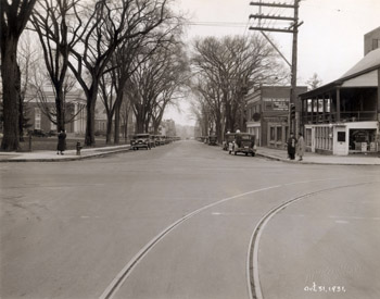
16 South Winooski Avenue Two McAllister photographs depict the appearance of the intersection of Pearl Street and South Winooski Avenue during 1931. Click here to see the other photograph. Taken as “before and after” photographs, the images show changes that were made to the streetscape at this time. In Photo 10, buildings and large American elm trees define the edges of South Winooski Avenue and enclose the space. Approximately nine elm trees of varying sizes and one evergreen tree are seen to the east (left) of the street, while seven to eight elms line the west side. Utility poles and overhead utility lines are also seen lining both sides of the street. South Winooski appears to be wide enough for two lanes of traffic with on-street parking to the west only. Several cars are parked alongside the west curb. The southwest (right) corner of the intersection is marked with a metal post containing a traffic light, street signs, and a lantern-style street light suspended from an “S” shaped bracket. On the opposite corner, a man is digging a hole adjacent to the fire hydrant as a small boy looks on. In the background of the image are three additional people with a truck. It appears that the east side of South Winooski Avenue is dug up for underground utility work. Photo 11, though similar to Photo 10, has some substantial differences. Streetcar tracks have been laid in the pavement and are seen turning from Winooski Avenue west onto Pearl Street in the foreground. South Winooski has been widened significantly to provide extra space for on-street parking to the east. Several cars are shown parked on both sides of the street in Photo 11. To widen the street, some American elms were removed, including four trees along the west side of the street. The metal post, street light, street signs, and traffic light was also removed. This is confirmed in the city report for 1931, stating, “It was necessary to remove about fifteen shade trees along the sides of this project in order to widen the pavement to the proposed width. The electric light poles also had to be reset on the westerly side of the Street.”(1) Two buildings are clearly shown in both McAllister photographs along the western edge of the street. The building located at the southwest corner (right) of the intersection is 7 South Winooski, while the adjacent building to the south is 11-13 South Winooski. The open green space with many trees at the southeast corner of the intersection is part of the property at 16 South Winooski. 7 SOUTH WINOOSKI AVENUE 7 South Winooski is a 1-1/2 story frame building with a two story frame addition and porch to the east. Though the main block is not seen in the photograph, the side addition is quite large, housing what appears to be a barbershop on the lower level. The upper level of the addition is a large porch with square posts supporting a shed roof. A three-bay stone addition to the rear of the building is punctuated by three large rectangular windows, while an overhead sign reads “Monumental Works.” In 1931, the Carl D. Densmore Company, Inc. monument company occupied the building, though no mention is given to the barbershop on the lower level of the east addition(2). 11-13 SOUTH WINOOSKI AVENUE A two story, three bay brick garage occupies the site at 11-13 South Winooski, just south of the Monument company. The east façade of the building showcases an elaborate cornice, large windows on the first and second floors, and Shell sign. On the north side of the building is a painted advertisement reading, “Yandow Tire & Battery Co., Storage 50Ë” The floorplan of the building contains an office, large entryway, auto supply room, and large garage with a capacity for 60 cars(3). Four gasoline tanks are located in front of the building along the street; the white signs on top two of the tanks can be seen just above the cars parked on the street in front of the building. Yandow Garage occupied of the building in 1931 and continued to do so through the early 1940s(4). Back to Depression Era Streetscapes.
(1) Report of City of Burlington, Vermont, 1931. (2) Burlington City Directory, 1931 (Burlington: H. A. Manning Co., 1916-1986). (3) Sanborn-Perris Map. Burlington, Vermont 1926 with 1935 updates. (4) Burlington City Directory, 1931, 1942 (Burlington: H. A. Manning Co., 1916-1986). |
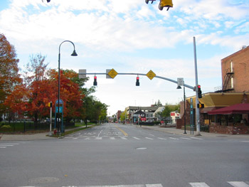
16 South Winooski Avenue The streetscape of the intersection of Pearl Street and South Winooski Street today is quite different. The widened street of the 1930s, now utilizes the former on-street parking spaces as an additional lane for through traffic. Loss of vegetation, buildings, overhead utility poles, and other landscape features along the street create an open space along the east side of South Winooski Avenue. More modern traffic lights, signage, and street signs have been added to the landscape at the street corners. Though the property at 16 Winooski remains similar in its historic character with deciduous trees, open green space, and iron fence, the buildings at 7 South Winooski and 11-13 South Winooski have been demolished. By 1942, the 7 South Winooski had been demolished and replaced with a small, one story cinder block gas station two gas tanks(1). The Shell Oil Company Station was the tenant of the building during this time, and then later changed to Bob’s Shell Service in 1972(2). During the late 20th century, the gas station was demolished and a blocky, angular brick building was constructed as seen in the photograph from 2006. Asiana House occupies the building currently. Similarly, 11-13 South Winooski was demolished prior to 1971(3). The site of the former building is now part of Asiana House, an adjacent alley, and parking lot for Brooks Pharmacy. Back to Depression Era Streetscapes.
(1) Burlington City Directory, 1942 (Burlington: H. A. Manning Co., 1916-1986). (2) Burlington City Directory, 1972 (Burlington: H. A. Manning Co., 1916-1986). (3) Burlington City Directory, 1971 (Burlington: H. A. Manning Co., 1916-1986). |
Historic Burlington Project Depression Era Streetscapes: Old North End | Burlington 1890 | Burlington 1877 | Burlington 1869 | Burlington 1853 | Burlington 1830 Produced by University of Vermont Historic Preservation Program graduate students in HP 206 Researching Historic Structures and Sites - Prof. Thomas Visser - in collaboration with UVM Landscape Change Program Historic images courtesy of University of Vermont Library Special Collections, Louis L. McAllister Photograph Collection |