
|
 |
 |
143 Pearl Street Photographed by McAllister during the 1930s, the intersection of Pearl Street and Elmwood Avenue is characterized by numerous American elm trees (Ulmus Americana) lining both sides of the street. The diameter of the trees is quite large, suggesting that they were planted in the late 19th century or early 20th century. The trees add an additional vertical element in the streetscape with high, upright branches arching out over the street, though their forms enclose the streetscape and direct and contain views down the street. The street appears to be quite wide with two lanes of through traffic and on-street parking on both sides of Pearl Street. The curb of Pearl Street is stone cut into segmented pieces. Also lining the street are overhead utility lines, which are seen just under the picturesque elm branches. Along the south (left) of the street are streetlights that hang over the center of the street for illumination at night. The lights appear to be a lantern style of light suspended from a chain from an overhanging arm. On the light post closest to the foreground is a narrow vertical sign reading “DYOLA.” The sidewalks appear to be somewhat narrow, probably no more than five or six feet wide. In the northeast corner of the intersection (right side of the photograph) is an elaborate cast iron and wrought iron fence with pointed finials. The fence encompasses the grounds of the 1st Unitarian Church, located at the top of Church Street on Pearl Street. The McAllister photograph shows numerous partial facades of residential and commercial buildings lining both sides of Pearl Street, including the Catholic High School to the south (left). Clearly seen in the photograph are properties 3-5 Elmwood and 118 Pearl. 3-5 ELMWOOD AVENUE At the intersection of Pearl Street and Elmwood Avenue is a large two story, three bay by six bay wood frame dwelling clad in narrow wood clapboards and capped with a gable roof. The building first appears on the 1853 Presdee and Edwards map, indicating it was constructed during that year or prior to that year(1). In 1869, J.H. Worcester owned the property and the building, but by 1901, Dr. Clifford A. Pease, MD occupied the building, either as a residence or office for his medical practice(2). The building remained at the intersection of Pearl and Elmwood until 1930 when it was relocated to the corner of Elmwood and Peru Street to provide space for the construction of a gas station(3). In 1931, Edward’s service station occupied the site and was constructed fireproof building materials with a small brick square “L” to the south with three gas tanks(4). By 1942, the gas station remained, but had changed names to George Crocker, Gas and Oil(5). For more information about 3-5 Elmwood, please click here. 118 PEARL STREET 118 Pearl is a two-story, three bay, frame dwelling in the Italianate style. Italianate characteristic features of the building in the Italianate style include the detailing of the window lintels and sills and the paired eave brackets. The building first appears on the 1877 bird’s eye view of Burlington, indicating it was probably constructed between 1869 and 1877(6). Three decades later in 1901, Henry J. Nelson occupied the building(7). However thirty years later, the building stood vacant, and was vacant in 1942. Between 1926 and 1942, the small enclosed front porch was constructed, and the porch to the east was enlarged(8). Back to Depression Era Streetscapes.
(1) Presdee and Edwards Map. Burlington, Vermont 1853. (2) Beers Map of Burlington Vermont. 1869; Burlington City Directory, 1942 (Burlington: H. A. Manning Co., 1916-1986). (3) Blow, David. Historic Guide to Burlington Neighborhoods, Vol. 1 (Chittenden County Historical Society, 2003); 42. (4) Burlington City Directory, 1931 (Burlington: H. A. Manning Co., 1916-1986). (5) Sanborn-Perris Map. Burlington, Vermont 1926 with 1935 updates. (6) Burlington City Directory, 1942 (Burlington: H. A. Manning Co., 1916-1986). (7) Beers Map of Burlington Vermont. 1869; Bird’s Eye View. Burlington, Vermont 1877. (8) Burlington City Directory, 1901 (Burlington: H. A. Manning Co., 1916-1986). (9) Sanborn-Perris Map. Burlington, Vermont 1926 with 1935 updates; Sanborn-Perris Map. Burlington, Vermont 1942. |
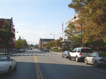
5 Church Street Much has changed looking at the landscape of the intersection of Pearl Street and Elmwood Avenue today. The majority of the smaller-scale residential buildings shown in the McAllister photograph have been demolished to make space for larger urban renewal projects. The large elm trees succumbed to Dutch elm disease during the 1960s, creating an open streetscape with expansive views, in comparison to the contained views of the 1930s. Vegetation today consists mostly of maple trees (Acer species) and shorter ornamental crabapples (Malus species). Pearl Street itself remains unchanged with two traffic lanes and on-street parking on both sides of the street. As mentioned previously, the original two story frame dwelling located at 3-5 Elmwood Avenue was relocated, and a gas station was construction in its former location(1). The gas station remained throughout the 1950s, when it and several adjacent properties, including 118 Pearl, were demolished to construct a new federal building. The new Federal Building was designed by the local architecture firm, Freeman, French, and Freeman and opened in 1960(2). The eight story building contains offices for numerous federal departments including the United States Post Office, General Services Administration, the United States Department of Agriculture Forest Service, District Attorney’s Office, and district courtrooms, among others. Back to Depression Era Streetscapes.
(1) Blow, David. Historic Guide to Burlington Neighborhoods, Vol. 1 (Chittenden County Historical Society, 2003); 42. (2) Blow, David. Historic Guide to Burlington Neighborhoods, Vol. 1 (Chittenden County Historical Society, 2003); 42. |
Historic Burlington Project Depression Era Streetscapes: Old North End | Burlington 1890 | Burlington 1877 | Burlington 1869 | Burlington 1853 | Burlington 1830 Produced by University of Vermont Historic Preservation Program graduate students in HP 206 Researching Historic Structures and Sites - Prof. Thomas Visser - in collaboration with UVM Landscape Change Program Historic images courtesy of University of Vermont Library Special Collections, Louis L. McAllister Photograph Collection |