
|
 |
 |
94 Pearl Street Like many of the downtown streets of Burlington during the 1930s and 1940s, the intersection of Pearl Street and Grove Street is characterized by tall, vase-shaped American elm (Ulmus americana) trees and overhead utility lines lining a primarily residential street. The street is wide with on-street parking to both sides, and a mailbox is seen at the northeast corner of the intersection of Pearl and Grove Streets. Three buildings are distinguishable in the foreground of the image, including 98 Pearl, 102-108 Pearl, and 97-103 Pearl. 98 PEARL STREET 98 Pearl is a two story frame dwelling with brick veneer sited at the corner of Pearl Street and Grove Street(1). First seen on the 1853 map of Burlington, the property was constructed during the mid 19th century, and was occupied by C. Eldridge in 1869(2). At the turn of the century in 1901, two people resided in the house—Mrs. Margaret Shepard and Wm. E. Whitney(3). By 1931, several additions were constructed to the north and east of the house, enlarging the dwelling; during this same year, Mrs. Eda A. Safford and Mrs. Eda M. Blodgett resided in the house(4). Mrs. Eda A. Safford continued to reside in the structure in 1942(5). 102-108 PEARL STREET To the east of 98 Pearl is a three story wood frame building with brick veneer. Like the adjacent property to the west, 102-108 Pearl has a similar history. In 1869, C.Eldridge owned the property and ran a store out of the easternmost portion of the building(6). By 1931, the building retained a similar footprint, but had been converted into apartments and offices. Tenants for 1931 included George Pecue, Mrs. Mabel A Rogers, boarding, Mrs. Anna J O’Kane, Charles A. Moss, and the Burlington Free Dispensary(7). By 1942, many of the building’s occupants had moved out, including the Burlington Free Dispensary. Four people resided in the building in 1942, including a barber shop(8). 97-103 PEARL STREET Historically in 1869, 97-103 Pearl was part of the Seymour estate located at the corner of Pearl Street and St. Paul Street(9). A large house occupied the site, but was demolished by 1901(10). Sometime between 1901 and 1931, the Catholic High School was constructed on the site(11). The building is a two story brick building with bearing wall construction, presumably associated with the adjacent Cathedral of Immaculate Conception. In 1935, the floor plan of the high school contained numerous class rooms flanking a gym and auditorium in the center of the building(12). Back to Depression Era Streetscapes.
(1) Sanborn-Perris Map. Burlington, Vermont 1942. (2) Presdee and Edwards Map. Burlington, Vermont 1853; Beers Map of Burlington Vermont. 1869. (3) Burlington City Directory, 1901 (Burlington: H. A. Manning Co., 1916-1986). (4) Burlington City Directory, 1931 (Burlington: H. A. Manning Co., 1916-1986); Sanborn-Perris Map. Burlington, Vermont 1926 with 1935 updates. (5) Burlington City Directory, 1942 (Burlington: H. A. Manning Co., 1916-1986). (6) Beers Map of Burlington Vermont. 1869. (7) Burlington City Directory, 1931 (Burlington: H. A. Manning Co., 1916-1986). (8) Burlington City Directory, 1942 (Burlington: H. A. Manning Co., 1916-1986). (9) Beers Map of Burlington Vermont. 1869. (10) Burlington City Directory, 1901 (Burlington: H. A. Manning Co., 1916-1986). (11) Burlington City Directory, 1901, 1931 (Burlington: H. A. Manning Co., 1916-1986). (12) Sanborn-Perris Map. Burlington, Vermont 1926 with 1935 updates. |
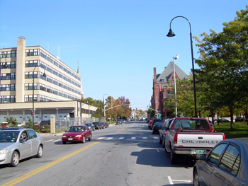
94 Pearl Street The existing view of the intersection of Pearl and Grove Streets retains very little of its historic character. Though the street width remains the same, loss of overstory vegetation and small-scale residential buildings have resulted in an open streetscape with tall, mid-rise buildings. By 1971 residential buildings including 98 Pearl, 102-108 Pearl were no longer present along Pearl Street. In the 1950s, several properties on the northern side of Pearl Street from Grove Street to Elmwood Avenue were demolished to provide space for a newly designed Federal Building. The local architecture firm of Freeman, French, and Freeman designed the eight-story building that opened in 1960(1). The building contains offices for numerous federal departments including the United States Post Office, General Services Administration, the United States Department of Agriculture Forest Service, and District Attorney’s Office, among others(2). The brick Catholic High School located across the street at 97-103 Pearl is no longer extant today. Though it continued in its educational endeavors throughout the 1950s, when the adjacent Cathedral of the Immaculate Conception burned in 1972, the congregation decided to rebuild the church using the entire city block(3). It is presumed that the high school was demolished to clear the block for the new Cathedral. The project landscape architect, Dan Kiley sited the new Cathedral in the center of the city block within a grove of 123 honey locust trees (Gleditsia triacanthos) that align to the exterior angled façade of the Cathedral. Some of the locust trees are seen on the right of the photograph. Additionally, the Masonic temple building which was constructed in 1897-98 in the Romaneque Revival Style is seen in the background from this vantage point(4). The building is located at the corner of Pearl Street and Church Street. Back to Depression Era Streetscapes.
1) Blow, David. Historic Guide to Burlington Neighborhoods, Vol. 1 (Chittenden County Historical Society, 2003); 42. (2) Blow, David. Historic Guide to Burlington Neighborhoods, Vol. 1 (Chittenden County Historical Society, 2003); 42 (3) Hapner, Chirstopher.“Fire Destroys Catholic Cathedral”, Burlington Free Press, March 14, 1972. (4) Blow, David. Historic Guide to Burlington Neighborhoods, Vol. 1 (Chittenden County Historical Society, 2003); 42. |
Historic Burlington Project Depression Era Streetscapes: Old North End | Burlington 1890 | Burlington 1877 | Burlington 1869 | Burlington 1853 | Burlington 1830 Produced by University of Vermont Historic Preservation Program graduate students in HP 206 Researching Historic Structures and Sites - Prof. Thomas Visser - in collaboration with UVM Landscape Change Program Historic images courtesy of University of Vermont Library Special Collections, Louis L. McAllister Photograph Collection |