
|
 |
 |
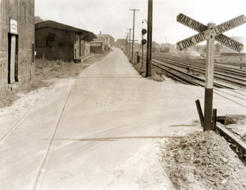
Intersection of Lake & Depot Streets Louis McAllister took this photograph of the intersection of Lake Street and Depot Street in 1936. The photograph reveals several character-defining features of the waterfront on Lake Champlain during this time. Numerous railroad tracks parallel Lake Street to the west (right), while one set of railroad tracks crosses the street at a diagonal to the east (left). The intersection of the two streets is marked with a railroad sign that reads, “Railroad Crossing, Look Out for the Locomotive.” A series of utility poles and overhead utilities lines are located between Lake Street and the paralleling tracks to the west. Two people, two vehicles, and four railroad cars are seen in the background of the image. The original caption on the back of the photograph reads, “A view of the project area looking south along its length from the intersection of Depot Street and Lake Street.” Four industrial buildings line Lake Street to the east. As Burlington became a major port city along Lake Champlain during the mid to late 19th century, raw goods were shipped via boat and rail to the waterfront in Burlington to be stored and processed into manufactured goods. In 1853, the waterfront consisted mostly of railroad tracks with a few buildings throughout the landscape(1). By 1877, the industry along the waterfront had expanded and several buildings were erected along the lakeshore (2). Warehouses, lumberyards, sawmills, and other industrial buildings such as those shown here, were popular structures along the Burlington waterfront during this time. Because these structures are industrial in nature, they were not assigned street numbers, which makes tracking their histories somewhat challenging. The building in the foreground appears to be a two story wood frame building, clad in vertical sheets of metal. At the time the photograph was taken, J.O. Middlebrook & Sons occupied the building, using it to store agricultural implements and twine(3). The door is located in the southwest corner of the building and is marked overhead with a “Quaker State Motor Oil” sign. The adjacent building to the south is a two story rectangular wood framed, metal clad storage building with a low-pitched gable roof and overhanging eave to the west. The eave provides some shade and protection from the elements when loading and unloading goods into the building from the adjacent railroad track. This building was also occupied by J.O. Middlebrook & Sons to store agricultural implements and fertilizer during the 1930s(4). Continuing south along Lake Street, the third building shown in the photograph is a one story, wood frame and iron clad building used for lumber and building materials storage. In 1935 it was owned by the Burlington Lumber Company Incorporated, whose sign is seen on the building in the photograph(5). The building is constructed of wood posts and beams and is divided into four north-south bays approximately 16-feet wide(6). The westernmost bay of the building may date to 1853 or before, as it appears on the 1853 map of Burlington(7). In the background of the photograph is a fourth building, which is a two story Sears and Roebuck & Company Merchandise Warehouse, owned by the John E. Booth Lumber Corporation. The building is framed with steel posts and beams with brick veneer and is used to house tire storage and agricultural implements(8). Back to Depression Era Streetscapes.
(1) Presdee and Edwards Map. Burlington, Vermont 1853. (2) Bird’s Eye View. Burlington, Vermont 1877. (3) Sanborn-Perris Map. Burlington, Vermont 1942. (4) Sanborn-Perris Map. Burlington, Vermont 1942. (5) Sanborn-Perris Map. Burlington, Vermont 1926 with 1935 updates. (6) Sanborn-Perris Map. Burlington, Vermont 1942. (7) Presdee and Edwards Map. Burlington, Vermont 1853. (8) Sanborn-Perris Map. Burlington, Vermont 1942. |
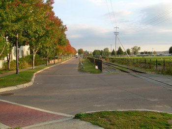
Intersection of Lake & Depot Streets Since the decline of the lumber industry along the Burlington waterfront, the land along Lake Champlain has been significantly altered. Many dilapidated industrial buildings and abandoned railroad tracks that were once used during the late 19th century and early 20th century remained along the waterfront throughout the mid 20th century. In the 1980s, the city of Burlington made efforts to clean up the former industrial waterfront in attempts to attract residents and visitors to the area for active and passive recreation. To accomplish these goals, new zoning regulations were adopted for the waterfront area, including Lake Street in 1986. Two years later in 1988, the Burlington bike path was completed, which turned the old railroad right-of-way to a scenic bike path along the waterfront extending north to Colchester and south to South Burlington. Strides to improve the Lake Street and waterfront area continued into the 1990s. In 1990, the city adopted the Waterfront Revitalization Plan, followed by the creation of Waterfront Park in the following year. Today the intersection of Lake Street and Depot Street is much more scenic than industrial in nature. Depot Street has been slightly realigned at the intersection allowing greater visual sightlines to oncoming traffic. The streets have been repaved, and curb and gutters edge both streets. A stamped concrete and painted crosswalk extends across Depot Street. Some of the railroad tracks remain to the west of Lake Street, though they are separated from the street by a decorative metal fence. An allee of maple trees (Acer species) lines the east side of the street, screening an adjacent parking lot and residential building.
|
Historic Burlington Project Depression Era Streetscapes: Old North End | Burlington 1890 | Burlington 1877 | Burlington 1869 | Burlington 1853 | Burlington 1830 Produced by University of Vermont Historic Preservation Program graduate students in HP 206 Researching Historic Structures and Sites - Prof. Thomas Visser - in collaboration with UVM Landscape Change Program Historic images courtesy of University of Vermont Library Special Collections, Louis L. McAllister Photograph Collection |