Grove Street: Northwest from City Limits |
|
|
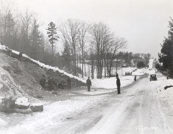
Louis McAllister took this image, dated February 23, 1940, from a point near the Burlington-S. Burlington city limits. In this scene, which was printed in the 1940 Burlington Annual Report, workers are making the borrow pit whose excavation will be used for grading the shoulders and sidewalk and filling the ravine. At this stage in the project, a telford stone base has been completed to the point of the white barricade visible on the road at right edge of the photograph, near the automobile.[1] Louis McAllister photographed this same location again on November 21, 1940, after most of the project was finished. Please click here to see this image. The view looks northwest along Grove Street toward the home of Charles A. Kirby, a market gardener, where the street turns sharply to the right at the Kirby house and continues north. Kirby's residence first appears in the Burlington directory in 1920. In 1940, the year this photo was taken, Kirby lived in the house with several of his relatives, including Ernest R. Kirby, a laborer, Leo Kirby, a truck driver, Leroy D. Kirby, a laborer, and Percy W. Kirby, a salesman. [2] The Annual Report indicates that the borrow pit was located across the street from the home of Nelson Bessette who, judging by the city directories, built his home at 200 Grove Street in 1924.[3] The 1940 Burlington directory lists two residents at this address at the time of the photo: Romeo R Desautels, electrician for the city Fire Department, and Milo H. Reynolds, farmer.
[1] Burlington City Annual Report, 1940, p 169. |
Today, the most striking difference is the thickness of the vegetation that has filled in the entire area. The Charles A. Kirby house, although now removed, would certainly not be visible from this point at the present day, even mid-winter. The Burlington directory suggests that C. A. Kirby died between 1949 and 1951. It appears that following his death, Kirby's widow, Myrtle B. Kirby, and son Leroy moved to 510 Patchen Road, just over the city line in South Burlington. Son Ernest remained at 99 Grove for several years but by 1956, 99 Grove Street is no longer listed in the Burlington directory. The road has been resurfaced with modern materials and a line in the pavement, created by the juncture of two paving projects, marks the geographical boundary between Burlington and South Burlington. The sidewalk at the right appears not to have been extended past its 1940 terminus. In addition, a small development was been constructed to the right at 200 Grove Street.
|
Historic Burlington Project Depression Era Streetscapes: Old North End | Burlington 1890 | Burlington 1877 | Burlington 1869 | Burlington 1853 | Burlington 1830 Produced by University of Vermont Historic Preservation Program graduate students in HP 206 Researching Historic Structures and Sites - Prof. Thomas Visser - in collaboration with UVM Landscape Change Program Historic images courtesy of University of Vermont Library Special Collections, Louis L. McAllister Photograph Collection |