
Main Street: Southeast to 565 Main UTM: 180643282E; 4926345N |
 Louis L. McAllister November 27, 1934 |
 Sarah L. Graulty October 15, 2006 |
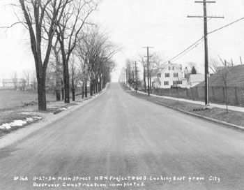
| Louis McAllister took this picture on November 27, 1934, after a road widening and resurfacing project on Main Street Immediately to the right of the city reservoir, looking southeast. For more pictures and information about the reservoir, please click here. The building just past the reservoir is 565 Main Street, constructed c. 1926. Its first tenant, D. William Doane, a local real estate man, first appeared at the house in the 1927 Burlington city directory. Doane continued to live here at least until 1935, so he would have been the resident when the photograph was taken in 1934. [1]
[1] Burlington City Directory, 1927-1935 (Burlington: H. A. Manning Co., 1916-1986) |
Today, very little change has taken place at 565 Main Street. The same can not be said for the surrounding area. The road is considerably wider, the row of trees lining the street is gone, and the front of the Burlington Reservoir has been carefully landscaped. The most jarring change involves the construction of the massive Dudley H. David Student Center on the left side of the image, set to open in September 2007. |
Historic Burlington Project Depression Era Streetscapes: Old North End | Burlington 1890 | Burlington 1877 | Burlington 1869 | Burlington 1853 | Burlington 1830 Produced by University of Vermont Historic Preservation Program graduate students in HP 206 Researching Historic Structures and Sites - Prof. Thomas Visser - in collaboration with UVM Landscape Change Program Historic images courtesy of University of Vermont Library Special Collections, Louis L. McAllister Photograph Collection |