Main Street: Northwest from East Avenue UTM: 180643957E; 4925941N |
|
 Sarah L. Graulty October 15, 2006 |
This image, captured by Louis McAllister on September 1, 1933, looks northwest along Main Street from a point on the Burlington-South Burlington city line, at the intersection with East Avenue. As the caption indicates, it depicts the area before street widening and resurfacing. The scene truly has the feel of a quiet country road, with its farm buildings, open spaces, and thick elm trees. The farm in the background is the University of Vermont Farm, likely built between 1890 and 1900. The farm does not appear on the 1890 C. M. Hopkins Map of Burlington, but it is on the 1900 Sanborn Fire Insurance Map, when it was marked "State Experimental Farm" and included a main barn, creamery, hot house, and a bee house. [1]From there, Sanborn Maps indicate that it grew every year, adding buildings and expanding those already on site. In this image, one can see many of the farm's barns and outbuildings, as well as the cupola-topped main barn (partially hidden behind the elms). To view other McAllister photographs and learn more about a 1933-1934 resurfacing project on Main Street, please click here.[1] Sanborn Fire Insuance Map, Burlington, VT, 1900. |
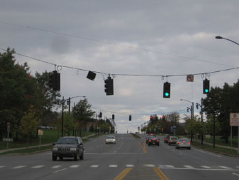
Today, Main Street at the intersection of East Avenue is a 5-lane road with frequent traffic lights controlling a complicated traffic pattern knows as the "jughandle". The areas on the left and right of the street are all owned by the University of Vermont, and one can see university dorms through the trees on the south side of the street. On the right, the site of the old State Experimental/University Farm is now a large parking lot. The University used the farm until the 1960s, when the Board decided that "the urbanization of Burlington makes it 'impractical' to have a farm in the city, and there is not enough space on campus."[1] In 1961, they decided to relocate farming operations to a site along Spear Street in South Burlington. The move was complete by 1965 and on September 25 of that year, the Burlington Free Press reported that the University was beginning to tear down unused buildings. "Removal of these two units," the article read, "marks the first step in eventual removal of most of the farm buildings in this area."[2] Although University President Fey said in 1961 he "hopes this land can be redeveloped for classroom or faculty or student residence use,"[3] today it is a paved parking facility.
[1] John Mullins, "Poultry Farm in Line for Summer Move" Burlington Free Press (26 Dec 1961) 11. |
Historic Burlington Project Depression Era Streetscapes: Old North End | Burlington 1890 | Burlington 1877 | Burlington 1869 | Burlington 1853 | Burlington 1830 Produced by University of Vermont Historic Preservation Program graduate students in HP 206 Researching Historic Structures and Sites - Prof. Thomas Visser - in collaboration with UVM Landscape Change Program Historic images courtesy of University of Vermont Library Special Collections, Louis L. McAllister Photograph Collection |
