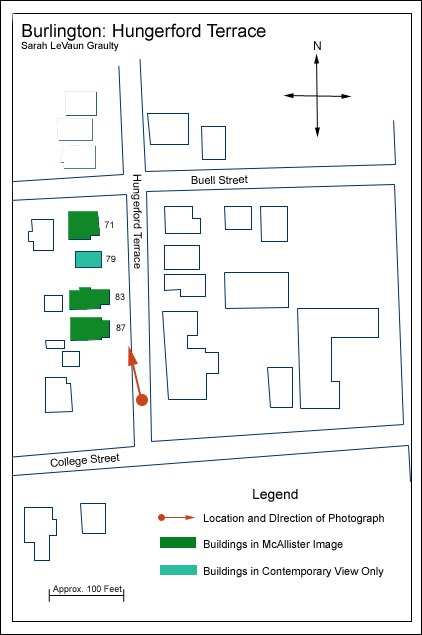
Hungerford Terrace |
|
This area is part of the Buell Street-Bradley Street Historic District, significant for its relatively quick development and “remarkable homogeneity of architectural style, and use, almost exclusively residential.”[1] The neighborhood was originally pioneered by two local residents in the mid 1880s. The 1886 Burlington Annual Report notes that “Buell Street, a new street extending from South Willard street to So. Union street, between College and Pearl streets, on land owned by Messrs. Edward Hungerford and Hiram Walker is to be opened by these gentlemen, entirely at their own expense. A portion of it has been curbed with plank. The street is not yet built but will be so during the coming year.”[2] Street Department receipts in the Annual Report from that year show that Edward Hungerford paid the city $659.70 cash for Buell Street.[3] The area’s streets developed in stages from this point. An 1894 Sanborn Fire Insurance map shows only Buell Street bisecting this area of land. Hungerford Terrace does not appear in the Burlington City Directory until its 1889-1890 edition, at which time it was less an independent street than an extension of Buell to the north and south, not yet connecting to either Pearl or College Streets, but the area was poised for great growth. A March 3, 1902 item in the Burlington Free Press noted that there was “more demand for houses on Buell Street than for those on any other street in the city, and on no other street has property advanced so greatly in value during the last ten years.” The street is officially labeled Hungerford Terrace on the 1906 Sanborn Map and shows several newly constructed houses, but still does not cut through all the way to Pearl or College. The very beginnings of Bradley Place are visible on this map, as well. 1910 was a year of significant street development in this district. Local attorney William Harrington purchased the former Peck homestead on the southern end of what would become Hungerford Terrace and the street was extended to connect with College.[4] Burlington’s 1910 Annual Report cites the construction of curbing, sewer lines, and crosswalks and College and Hungerford. [5] 1911 and 1912’s Annual Reports show significant construction and improvements on both Hungerford and Bradley and by 1912, a Sanborn Map shows the grid completed: Hungerford stretches from Pearl to College and Bradley from South Union to South Willard, parallel with Buell.[6]
[1] Buell Street-Bradley Street Historic District National Register nomination |
Historic Burlington Project Depression Era Streetscapes: Old North End | Burlington 1890 | Burlington 1877 | Burlington 1869 | Burlington 1853 | Burlington 1830 Produced by University of Vermont Historic Preservation Program graduate students in HP 206 Researching Historic Structures and Sites - Prof. Thomas Visser - in collaboration with UVM Landscape Change Program Historic images courtesy of University of Vermont Library Special Collections, Louis L. McAllister Photograph Collection |