Introduction
The following report is meant to offer a description of the
current state of the Fond D'Or Bay mangrove ecosystem as we understand it from
our two weeks of field research and dialogue with experts and local community
members. We aim to provide
management recommendations for our sponsor agency, Integrating Watershed and
Coastal Areas Management (IWCAM-Saint Lucia), especially with regards to its
preservation and sustainable use values, which can help direct future plans for
the study area, possibly avert
some development pressures, and identify ways the Fond D'Or Bay mangrove can be
protected and used for sustainable harvest or ecotourism.
Problem Background
The main goal of this project is to determine the
ecological, social, and economic values and current uses of the mangrove
ecosystem at Fond D'Or Bay, Saint Lucia.
This research is borne out of a desire by our main project sponsors, the
Saint Lucian authority on Integrating Watershed and Coastal Areas Management
(IWCAM) to extend their watershed management from the interior down to the
near-shore and coastal areas of the island (following the ridges to reefs
concept).
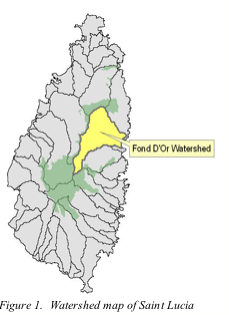 Fond
D'Or Watershed (see Figure 1) is on the central eastern coast of St. Lucia,
just north of the city of Dennery.
It was selected as the location for the IWCAM demonstration project and
its various components because of its unique attributes – it is one of
the largest watersheds in Saint Lucia, providing waters for residents of the
Dennery constituency but faces some difficult water quality challenges.
Fond
D'Or Watershed (see Figure 1) is on the central eastern coast of St. Lucia,
just north of the city of Dennery.
It was selected as the location for the IWCAM demonstration project and
its various components because of its unique attributes – it is one of
the largest watersheds in Saint Lucia, providing waters for residents of the
Dennery constituency but faces some difficult water quality challenges.
The mangroves at Fond D'Or Bay are not being actively
managed by the state authority that oversees them and face possible risk of
development or over-use. Probably
due to their general inaccessibility, they have been overlooked until recently.
The most important elements of the problem identified by
IWCAM were the need for mapping the area, identifying the species therein, and
describing the ecosystem health and ecological integrity of the Fond D'Or Bay
mangroves. Other important
elements we were charged with exploring was the level and type(s) of uses impacting
the mangroves by the local residential, agricultural, and business
communities.
Review of
literature
Our literature review explored some mangrove ecosystem
health valuation frameworks, protocols, indicators and tools currently in use
in other Caribbean Small Island Developing States (SIDS) and throughout the
world, broken down into sections on:
watershed and wetland management in Saint Lucia and historic and
economic uses in the context of Caribbean coastal areas and mangrove
ecosystems.
Watershed
& Wetland Management in Saint Lucia
One of the main issues that the world is facing today the
availability of fresh water and managing the use of water. Many small island
nations, such as St. Lucia, need comprehensive management plans for their water
resources in order to have water security for the future and to make sure what
happens on the island now has less of an impact on that security. St. Lucia has
the problem of having a lack of water catchment and natural aquifers, so there
is little storage and distribution of freshwater throughout parts of the
country. In the rural areas, water scarcity during the dry season has reached
critical capacity (Ministry of Physical Development Environment and Housing,
2004). Water quality is also becoming more of a problem due to higher rates of
erosion and sedimentation from agricultural and tourism land-use practices as
well as improper waste water discharge (Ministry of Physical Development
Environment and Housing, 2004).
One way to manage
watersheds is to involve education, legislation, physical management, the use
of constructed wetlands, and the use of other filtration systems for waterways.
Education is geared towards informing the communities impacted by water
mismanagement and those who may practice unsustainable land use about the
issues at hand and to get a dialogue started between all the stakeholders
involved. Legislation can go as far as penalizing those who contribute to
degradation of water quality and set standards for what are appropriate land
use methods as well as designate protected areas. One integrated method is
using wetlands as natural water filtration and retention by creating new
wetlands or helping existing ones grow.
The maintaining of coastal mangroves and wetlands is
important to maintaining water quality. Mangroves are forested areas along the
coast that are comprised of species that are adapted to salt water conditions
and act as an in-between area for saltwater and freshwater aquatic species.
Common tree species are the red mangrove (Rhizophora mangle), white mangrove (Laguncularia racemosa), and black mangrove (Avicennia germinans) that provide intricate root systems in the water
that provide habitat for many types of fish and crustacean species. Many
juvenile stages of fish develop in mangroves before moving out into the ocean.
The root systems also filter excessive nutrients and silt from draining into
the ocean when they are at river mouths, hold onto soil to prevent erosion of
coastlines, especially during hurricanes or tropical storms (FAO 1998). Many
bird species also use mangroves for habitat, including several ibis species,
mangrove warblers (Dendroica petechia bryanti), bicolored conebill (Conirostrum bicolor), various gulls and terns, and many others.
Sustainable coastal area management is extremely important ecologically for
wildlife habitat, maintaining water quality, and flood control. Most of these
coastal mangroves are being lost at a fast rate due to development on the coast
or due to unsustainable harvesting practices. One thing that is important is
that these coastal mangroves are maintained, monitored, and protected.
The mangrove that the Integrating Watershed and Coastal Area
Management (IWCAM ) Project wants assessed is the Fond D’Or Bay mangrove. The
Fond D'Or watershed is the second largest in St. Lucia comprising 10,230 acres
(MAFF 2009). The dominant mangrove type and communities are estuarine Rhizophora at a river mouth and basin Rhizophora occupying depressions that aren’t directly connected
to the sea (Lacerda, 1993). The Fond D’Or mangrove is approximately 2.5
hectares in size and contains the tree species Dragons Blood Tree (Pterocarpus officinalis), which is an uncommon tree prized for its dark wood
and dye that can be made from the bark (WAC 2008). The objective that the IWCAM
wants to achieve is to determine the types of species and abundance in the Fond
D’Or mangrove for possible preservation uses and determine how the mangrove
impacts water quality in the area.
Historical & Economic Uses of the Fond D'Or
Mangrove
As described above, mangroves provide important ecosystem
services that sustain land-based communities and aquatic systems, while also
improving and maintaining livelihoods for human use. In Saint Lucia, one mangrove in particular on the Mankoté
peninsula, has an interesting history of use for charcoal production,
concealment of fighter planes and even some agriculture (1998, Geoghegan).
The Fond D'Or mangrove has suffered little direct impacts,
although they have likely followed the same national trends that show a slight
decrease in forested land areas, which is also mimicked throughout Latin
America and the Caribbean (FAO, 2005).
According to an interview with members of the IWCAM, the study area has
likely experienced some limited collection pressure of saplings and small trees
for use as poles to support agricultural crops like yams and is the site of
local crabbing expeditions (pers. comm., October 2009).
Fond D'Or Bay Mangroves Project Concept
The project design approach selected was based on what was
known about the ecological and socio-historical context of the Fond D'Or
mangroves, which have in recent years been largely overlooked by it's managing
authorities, primarily the Department of Fisheries and the Crown Lands
Department in MAFF. An alternative
to this study could be an estimation and extrapolation of value based on
assessments conducted elsewhere on the island or throughout the Caribbean, but
this approach provides a much less reliable indication of the place at hand and
does nothing to incorporate the needs and desires of the local stakeholders.
Previous University of Vermont Student Work on Watershed Management
The current study builds upon previous partnerships
between service-learning students from the University of Vermont and IWCAM, all
of which aim to demonstrate effective and sustainable techniques for watershed
management. During the first visit
of University students to Saint Lucia (academic year 2004-2005), students
explored watershed concepts alongside partners in the Saint Lucian Water and
Sewage Company (WASCO), the Caribbean Natural Resources Institute (CANARI), and
the Ministry of Agriculture, Fisheries and Forestry (MAFF). The following year, students in the
course surveyed residents in contingent valuation methodology to determine the
value in employing watershed management practices where the aim is in
protecting water quality via best land practices of upstream forests. In from
2007-2009 two projects centered on watershed management, one working
specifically on the construction of a waste water treatment system known as a
constructed wetland and conducting a watershed level economic analysis through
community surveys (in both instances, the University partnered with
IWCAM). The current year's project
brings the work from “ridges to reefs”, as the watershed management slogan
goes, integrating lessons learned from previous projects.
Objectives and Methods
Until recently, the Fond D’Or Bay mangroves have not been
looked at specifically in terms of their biological health and their use to the
surrounding communities. Our task in this collaboration was to see how locals
use the area and to determine if there were any indications that the mangrove
is in danger of being unduly negatively impacted. We were also interested in understanding what effects
increased disturbances and/or unsustainable disturbances could have on the
surrounding natural and working landscape and in the lives of community
stakeholders.
We conducted a landscape analysis of the area, keeping a
careful eye for what natural communities were present, preservation of
biodiversity, conflicting land uses and development pressures, sustainable use
for locals and ecotourism ventures, and indicators of the status of the
ecosystem. For this, we used several
standard water quality and forest health assessment measurements, which are
discussed below and interviewed several key-informant community members which
represented the major local stakeholders. We will be submitting this work for
review by the local experts to continue the process.
In consultation with these experts
and through literature review of publications in the field of mangrove ecology
and management, we hope to offer some useful insights on this small but rich
study plot.
- Objective
1: to assess the health
status of the mangrove and its ecosystem functions:
◦ This included mapping by walking the
perimeter of the mangrove and taking Global Positioning System (GPS) points of:
▪ edges
and transition areas
▪ natural
communities
▪ waterways
▪ trails
and other significant landscape features
◦ To
determine the biodiversity, we walked through and around the mangrove in
sections, completing two transects, each with two plots we did:
▪ counts
of trees (defined as woody species with a diameter at breast height (DBH) of
> 5cm) and regeneration (woody species with a DBH of < 5cm).
▪ Tree
identification
▪ Tree
height (using a Hager altimeter field tool)
▪ field
observations
◦ Water
quality tests at three points along the river (at its mouth, at a midpoint
within the mangrove community and beyond the mangrove extent, as it transitions
into marshland and farming areas).
The tests, which were administered three times at each location,
included:
▪ temperature
▪ turbidity
▪ dissolved
oxygen
▪ depth
▪ pH
▪ alkalinity
▪ nutrient
loading (phosphates and nitrates), and
▪ bacterial
content (e. coli and general coliform)
- Objective
2 was to see how the mangrove was being used by the local community
members
· determine
is any harmful practices were being done.
· to
understand if any members of the community were relying on the mangroves for
subsistence use.
· Identify
sustainable use guidelines that could be shared
· provide
suggestions for educational and research opportunities being provided or
possible of the site
· promote
community engagement in the mangroves to influence stakeholders towards more sustainable
practices
· identify
opportunities for other uses, such as ecotourism
The Desired Ends
The project's main objective is to live out the mission of
our sponsor in integrating watershed and
coastal areas management, particularly with sustainability in mind. The project also addresses the
Millennium Development Goals of ensuring environmental sustainability (#7)
through the management and policy implications of the study and possibly to develop
a global partnership for development (#8) by creating a model for sustainable
management that can be used by conservationists and land managers working on
similar mangrove properties.
Results and implications
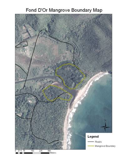 Figure
2. Map of mangrove boundaries Figure
2. Map of mangrove boundaries
|
|
As seen in Figure 2, the study are lies on both sides of the
Fond D'Or river, in the ½ kilometer or so as it drains into the
beach. An outline of the
mangroves, as encompassed on foot and recorded with the aid of a GPS field
tool, is shown in yellow, with some roads shown in black (these become less
accessible by car as you get closer to the wetlands).
The southern part of the mangrove is accessible by motor
vehicles in two places, both of which are gated. The back gate is considered a “VIP” entrance, by some (being
the access point for the parking behind the stage area used for concerts during
JazzFest) and the other is up the road at the main entrance to the Fond D'Or
Natural Heritage Site.
There is a drainage ditch that follows the VIP parking area
that leads into a large grassy area on the south bank of the river. There are many crabs in the area that
are hunted by some of the locals and sold on the roadsides near Dennery or in
to some restaurants in the valley on a weekly basis (in time for the weekend
crab specials). The southern trail
leads through mostly Almond forest with trees that the locals call “mami”. The almonds and “mami” are the dominant
species, being the largest members of the forest canopy and shading out most
understory growth. Closer to the
beach, the area is made up
predominantly of coconut trees with some large red mangroves and a few
white mangroves mixed in. Along the river, the ground is more saturated and
there are a few red mangroves mixed in with the “mami” trees, which out-compete
the mangroves in certain places.
There appears to be very little ground-cover and regeneration of small
trees in the forest.
There were many juvenile crabs on the swamp floor, which is
a good sign that the crab population isn't being over-exploited and they are
reproducing at a steady rate.
There were many signs of birds in the area, mainly a lot of sightings
and bird calls that were observed.
Some of the species observed were the bananaquit, mangrove cuckoo, and
several hummingbirds, egrets, and blue herons. The birds could take refuge in
the large, intertwined vines in the canopy and had plenty of available food in
the form of mosquitoes, nuts, and flowers. Further study could be done to see if there is a lot of bat
activity in the area at night.
Other animals observed were lizards, a few mongoose, hermit crabs along
the beach, and there were plenty of termite nests on the trees.
The northern side of the river is not easily accessible,
since there are only a few dirt roads that go along the river and through the
farms of the Ramjou banana company lands.
The main dirt road we used (closest to the water's edge on the north
side of the river) ends at pastureland that goes up close to the river bank
where you will see cows grazing.
One has to go through some marsh land to enter the mangrove.
The northern mangrove is more expansive and has plenty of
areas that have saturated soils and even large pools of water. There are areas
where the “mami” tree is dominant in the drier spots, but there are a lot of
black mangroves towards the center and red mangroves on the fringe where there
is plenty of water. There
unfortunately is a lot of trash, mostly bottles, that can be found throughout
the mangrove, apparently following the river's flood zones, and seems to be a
large problem on the north side.
There didn't seem to be as many crabs on the north side, but there were
still a lot of waterfowl and other birds in the mangrove. Most of the same
animal species were found here, but there weren't as many almond trees and was
mostly mangrove and mami trees.
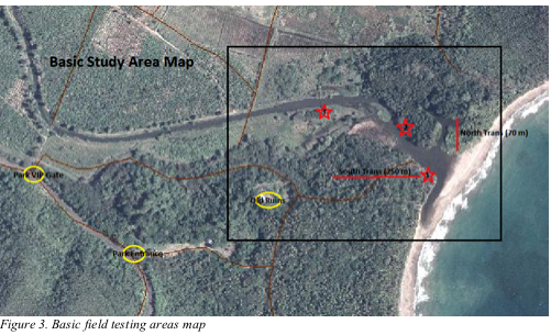
Water quality testing
The quality of the water in the Fond D'Or river was tested
at three locations along the river (see Figure 3). The first site was located near the mouth of the river,
where it meets the ocean and was located on the south side. The second site was in the middle of
the mangrove on the north side, surrounded by mangrove forest. The third site was upstream of the
mangrove on the south bank where there was mostly grassland up-river. Three samples were taken at each site
on different days. Water samples were analyzed for dissolved oxygen, pH,
alkalinity, turbidity, nitrates, phosphates, total coliforms, and E. coli.
Values for each were compared to the accepted values according to the EPA and
other sources (Table 1).
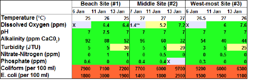
Table 1: Water quality test results with acceptable levels shown in green, less
optimal levels shown in yellow, and unacceptable levels shown in red.
Most of the variables were at acceptable levels with a few
exception. The dissolved oxygen at the middle site was low at the middle site
on one day, but we hypothesize that this is due to over titration during the
field analysis. The turbidity was
high on January 13th because there was heavy rain the day before, so
these values are considered normal for the condition that they were sampled in.
The only values that were exceedingly high were the coliform and E. coli coming
from manure and human waste that drain into the river either directly from
ditches that go through the mangrove or from runoff on the stream bank where
the cattle graze. The E. coli
levels are about 100 times the acceptable United States Environmental
Protection Agency levels for recreational swimming and the coliform is about
7-9 times over the limit.
Future recommendations would be to restrict swimming in the
river and possibly the ocean in certain parts. The ocean needs to be tested to see if there are unsafe
levels of E. coli and coliform where bathing is permitted. It should also be made clear if the
beach is suitable for swimming and bathing, since there were a few conflicting
signs that either said “No bathing” or “Bathe with caution.” Action also needs to be done in order
to reduce the bacteria levels by either controlling the pollution at the
source, i.e. prevent waste from enter the river directly and create riparian
buffers, or to do some sort of remediation effort. There are currently studies being done using bags inoculated
with certain species of fungi to clean E. coli invested water due to the
antibiotic properties of fungi (Stamets, 2003). Implementing a composting
toilet type of treatment to human waste might also reduce the inflow of E. coli
from the source, since studies show that E. coli doesn't survive long after
exiting the body and is isolated from a water source (Oikos).
Forest health
In order to determine the overall health of the mangrove,
two transects were done, one of each side of the river. Each transect contained two plots
measuring 10 meters by 10 meters.
Tree species, diameter, and height were taken at each plot to determine
species richness and biodiversity.
Observations were taken to see if there was any new growth or trees that
were cut down.
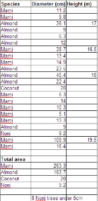
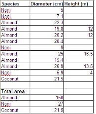
Tables 2 & 3: Transect 1, plots 1 and 2 on the south
side data. The dominant tree species in plot 1 was the Mami tree and in plot 2
it is Almond.
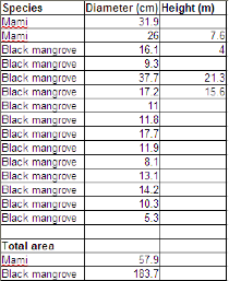
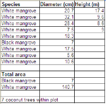
Tables 4 & 5: Transect 2, plots 3 and 4 on the north
side. More mangrove trees were present on the north side and both plots had
different mangrove species as the dominant tree species.
On the southern side, the transect did not encounter any
mangrove trees, but there were several trees that the locals call “mami” and we
hypothesize to be Pterocarpus officinalis. Each plot had little biodiversity
within the plot, but there were distinct communities from plot to plot. This is a good indicator that there
isn't one dominant species throughout the mangrove area and the lack of
diversity within an 10x10m plot is to be expected. Each dominant species in an area had varying diameters which
indicates that the ages are most likely variable. This leads us to conclude that there is probably very little
harvesting of trees in the area, or at least that little has been done in the
past.
More research needs to be done on the “mami” tree that we
think is Pterocarpus officinalis.
Pterocarpus officinalis is a
valuable hardwood tree and is a freshwater swamp species that is losing habitat
in many islands in the Caribbean (Riveria-Ocasio, 2007). Conservation efforts may need to be
done to ensure that not only is the current habitat is left unaltered, but that
the tree is introduced into places that it once occupied on the island in order
to preserve the genetic diversity of the species as a whole. If it is not the Pterocarpus, more investigation needs to be done to see if it is
a nuisance or invasive species that may be occupying mangrove habitat. It seems unlikely since there were
specific plots of large “mami” trees which indicate that they have their own
niche that they occupy.
Stakeholder interviews
Local community knowledge is often key to understanding a
place. For that reason, along with
our field explorations, we reached out to members of key stakeholder groups for
interviews. We had learned during
our preliminary studies of the area that the area has come to the attention of
developers, looking to build a golf course in the country's fairly rural
southeast section (pers. comm., October 2009) and wanted to understand this in
a bit more depth, while also getting a sense for how the mangroves where being
used on a day-to-day basis.
There were 6 stakeholder group members interviewed,
ranging in age from 21 to 68, some of which were single parents, married with
kids, and single with no kids. The
majority of the folks interviewed lived in the surrounding communities and had
lived there most (if not all) of their lives; communities represented are La
Caye, Richfond, Dennery, Lumiere.
They ranged in educational levels from secondary school to individuals
with masters degrees and represented members of the business, non-profit, socio-cultural
groups, and the residential communities.
Interviews were kept informal, not following an exact set
of questions, but covering the areas of history, current uses and access. Some of the key findings from the
interview include a rudimentary understanding of the history of the area, uses
of the mangroves, and some indication of perceived management responsibilities
and community concerns. The
following bullet points emerge from notes taken during the interviews,
organized by thematic area, across interviewees.
The interviewed community members were:
Andrew Mathurin (also known in the community as Edan or
Apachee) -- Overseer, Ramjou Corporation
Leyana Felicien – President, Mayouba Valley
Environmental Club
Cornelius Edmund – Acting Chairman, Fond D'Or
Foundation
Cornelius Isaac – Project Manager, GEF-IWCAM Saint
Lucia Demonstration Site
Lawrence Polinis (also known as Edwin) – Security
Guard, Ramjou Corportation and tailor
History of the Fond D'Or Bay mangroves
· From
17th century to 1960's, area was mostly used for sugaring
· in
1960's, Dennery Factory started banana crops
◦ 70's
to 90's – diminishing banana crops
◦ late
90's Ramju Corporation replaced Dennery Factory
◦ currently
about 50 acres with 20 laborers working out of Ramju
· until
early 80's – Land throughout the area (entire Mayouba Valley) used to
belong to Mr. Bernard
· '80(?)
Hurricane Allen passed and removed many of the coconuts
· '80s
– Forestry took some people to court in the area – more in relation
to the hillside lands. When project came into view, MVDP was planting dry land
species, but not in the mangrove area itself.
· 80's-'92
– sand extraction for use in construction throughout Saint Lucia.
◦ Sand
was extracted daily (large trucks existing with truckloads every day)
◦ sand
mining took up habitat on beach
◦ since
sand mining, there seem to be more trees, in general
· '95(?)
– Natural Heritage Park created
· '03
MVDP (created or dismantled..?)
· '05
– Land Rationalization process
· '07
– Watershed Management Commission initiated (currently in process of
becoming NGO)
· April
2008 – designation of park as managed by Fond D'Or Foundation
· many
people's latest impression is that the mangroves are currently managed by
Forestry
· Fond
D'Or Foundation came out of the need to make something out of Fond D'Or area (whole
watershed), but looking at park as fulcrum to raise awareness and help
development in the Mayouba Valley as well as in Dennery.
· Originally
(after Mr. Bernard) some lands owned by the NDC. When government set up MVDP (funded by EU), they created Land
Co. However, since MVDP went
defunct, some lands may have gone back to the NDC. [interviewee unsure, but
would expect land was split between NDC and Ag)
Current uses of the mangroves
· Crabbing
◦ year-round
◦ crabbers
self-regulate and do not harvest gestating females
◦ many
animals are collected for sale to restaurant(s) in Marigot Bay which offer
weekend crab specials
◦ several
methods exist, including:
▪ blocking
crab holes of air for 15-30 minutes and holding the crabs once you unblock the
hole
▪ digging
holes in crab locations and reaching in to pull crabs out
◦ crabs
sell for about EC$ 2-3 each, commonly being sold in sacks for $20-$40.
◦ crabbers
from Fond D'Or often go crabbing late at night (when crabs are more likely to
be active) or early in the morning and sell at regular locations on the side of
the main road near Dennery
◦ possibly
as much as 10% of the local population partakes in crabbing to supplement their
income (some more regularly than others)
◦ another
interviewee guessed as many as 50 crab hunters from Lumiere and La Caye who
sell to both local people and to restaurants.
· fishing
in Fond D'Or River
◦ for
human consumption
◦ for
bait
◦ year-round
(different fish available at different times)
◦ fishing
often happens at night (better catch)
◦ interviewees
weren't sure if they knew of people getting sick from eating the fish harvested
from the river (or didn't want to tell), but did share that you could often
taste mud in the fish
· wood
extraction limited
◦ no
real charcoal production – no pits
◦ however
no real deterrent to charcoal, either (other than difficult landscape)
◦ Forestry
fellows restricted it and took some folks to court in the past
◦ some
harvesting likely happening for yam poles and props
▪ [for
one interviewee this not a source of concern]
▪ [another
interviewee reported never have seen it happen]
◦ in
the past (several years ago, prior to popularity of fiberglass canoes), red
mangroves would have been used for structural support in wooden canoes
◦ report
of someone chopping some mangrove recently closer to the road
◦ some
folks harvest coconuts by the sea
◦ some
plants collected for medicinal purposes (indigestion aid)
· some
recreational bathing
◦ accessible
from either side of the river, but usually approached from the south side
◦ most
people walk in, but some bike to the beach
◦ some
see it as too dirty for bathing
◦ generally
unsafe place to swim, lives lost yearly to this beach
◦ recreational
bathing more common on the weekends (Sundays)
· interest
in using local natural areas (including mangroves) for environmental education
and community involvement
◦ clean-ups
◦ tree
plantings and restoration work
◦ educational
workshops and activities
◦ ecotourism
– some sort to wetland that people can walk through and fish, but still
allows for research
▪ were
in negotiation with a local business person (from Castries, “Luzi”?) who
operates kayak business in Rosalie, but haven't gone through with meetings
because of cleanliness issue
◦ idea
to use coconut to create barrier in mangroves for planting wetland flowers.
· Most
folks accessing and using the mangroves on the south side of the river –
using park entrance, back gate isn't used often.
· Not
very many people using the north side
· Folks
tend to go into mangroves in groups (4-5)
Community concerns
· mangroves
are viewed as an important part of the life cycles of important fisheries
species
· one
interviewee had a bad experience in the mangrove (allergic reaction to water,
skin irritation and swelling) after participating in a clean up event.
· Mangroves
identified as dirty from the litter
· water
seen as silty, possibly due to farmers digging drains which results in runoff
· similarly,
farmers are perceived to not use fertilizers properly (this interviewee thought
they should be applied underground for best use).
· Concerns
about education being the key to lifestyle changes – “nobody knows what
harm is being done”
· desire
to work with youth in order to share the message with the community via the
children
· lack
of support for environmental education, but seeking funding from local
donations and international grant sources
· in
the past tree plantings were done along Grand Ravine and La Caye and excess
trees were distributed to farmers to hold soil in place (and decrease
sedimentation of the rivers).
· There
has been a decrease in fish populations due to roads and quarries being built
· sense
that nobody cares about environmental work being done because there is debris
discarded even 5 minutes after a clean up.
· as
recently as '02, education group used the beach by the mangrove for a
recreational outing (BBQ), but not used as much for leisure anymore.
· Since
and before studies done by the ministries, nothing has come to fruition
- One
reason for the current situation is that people are ignorant to what is on
the ground. In a broader sense, at one point the land was under the
Bernard estate, which had armed security guards patrolling the entire
estate, so there was little harvesting and trees were allowed to grow. Now
that is dismantled and open for others to go in and do anything.
- We
need to identify the types of services that the mangrove provides
(fisheries and wildlife habitat, water quality) – it all needs
research in order to come up with value to watershed and Saint Lucia. All watersheds are losing
mangroves as if they mean nothing.
Perceptions of management responsibilities
· Uses
of the mangrove today are self directed and two interviewees seem to prefer it
that way
◦ good
for people to come and go. Don't know who manages it, don't really care.
· The
Fisheries Department seen as national level managing agency
· don't
want to mangroves to be private (inaccessible to public), but doesn't want it
to go unamanaged
· Folks
in charge of Natural Heritage Park only pay attention to the side of the park
that is marketable – should expand their management to include mangroves
· land
previously in the hands of the Ministry of Agriculture, but no real map
existed.
· Various
studies have been done on the area by different branches of the government, but
no boundaries set.
· Natural
park boundaries would be the river, the road (up to Moure Valle) and the beach.
· As
Fond D'Or Foundation, we'd be really interested in conserving the mangroves and
being guards and replanting and creating wetland for use.
- Fond
D'Or Foundation are in the process of becoming a legal NGO and will need
land demarcation.
- Their
plan is to create benefits and open the area for use, while providing
guardianship
- Have
security guards in the park, but will look at other things like security
lighting and possible infrastructure to create ownership and increase
responsibility factor.
- IWCAM
is a project, with an end.
Hope to provide sufficient information for environmental club and
watershed management NGO (in the process of being created) to continue to
provide mangrove services.
- Idea
is when project ends to pass lessons learned to entity so that they
continue working on these issues and benefits of project don't go to
waste.
- Commission
includes wide range of stakeholders – mission is to achieve
recreational water goal standards in all rivers, which would require
membership of people throughout the island.
- Mangroves
are one of the areas identified by the Fisheries Department as marine
reserves. They need to formalize that arrangement – make it legal
and more of a government policy position. While declared, there's not
capacity to manage it on the ground (paperwork vs. real).
- Would
be good to manage it with assistance from other companies – land
belongs to government Crown lands.
- The
current state of open access is bad – will eventually lead to over
harvesting. However, if
people have no sense of ownership, they wouldn't care about conservation.
Future actions recommended
The purpose of this report is to identify the
characteristics of the Fond D'Or mangrove area and give recommendations for
it's future use. There are number of uses of the mangrove now and it is
important to report these uses and information about the mangrove for people to
reference in the future and to know more about the land that is at the bottom
of their watershed. This can be used for educational purposes to integrate
people with the land and water management and give direction for any possible
projects in the area in the future.
To start, we offer a few simple field methodology
recommendations, which may improve future monitoring protocol and provide a
more accurate set of results. We
also offer some longer-terms needs areas and suggestions for management and
remediation.
Mapping:
- Re-walk
the perimeter of the mangroves with a GPS tool of higher accuracy. Alternatively, change the methods
for collecting GPS points so as to assure a greater accuracy for the same
machine. Our results ranged
from a margin of error anywhere between ± 3-40 meters. Given the small size of the plot,
the higher margin of error is not helpful for plotting information.
- Field
walk site with Allen Smith, author of two of the works cited in this
study. His report identifies
the mangrove habitat as consisting of under an acre, surrounded by almost
10 acres of marshy/wetlands.
If he is not available in person, at least reach out to him by phone
or email to find the areas of difference and convergence between his
landscape analysis methods and our own.
- Determine
map boundaries for as many parcels as possible directly adjacent to study
area.
- The
southern boundary is not yet final as per the perspective of the Natural
Heritage Park managers and may possibly be extended to include the entire
southern section of the study area, so as to use the river as a natural
boundary. This needs to be
clearly set to paper for management.
- Mr.
Edmunds suggests we reach out to Christopher Cox (then head of commission
and minister of ag about maps created about 5 years about, demarcating
boundaries
Water Quality Sampling:
- Continue
water quality sampling for at least a full year period so as to include
the rainy season.
- Conduct
bacterial testing into the beach area that is current used periodically
for recreational bathing, so as to confirm that the coliform and E. coli
content are within swimming levels
◦ Change
“No Bathing” and “Swim At Your Own Risk” signage, accordingly
- Explore
options for getting water samples from further into the center of the
river
◦ Using
hip waders to enter into river for sampling
◦ Throwing
object into water (please note that it would still be important to measure
certain qualities about the exact site of the water quality sample, such as
depth, distance from bank, temperature, and that the dissolved oxygen methods
require two hands to be submerged for the sample collection)
◦ Possible
canoe put-in at shallower entrances to water (by the beach)
· Although
not vital for further study, exploring the macroinvertebrates of the river can
offer a much clearer picture of water quality, given that species and genus
offer a biological indication of pollutant concentrations, given their limited
(or great) tolerance.
Forest Health:
· Add
additional transects and study plots to areas currently left unstudied,
especially on western edges of study area north of the river.
· Confirm
the currently existing uncertainty that the tree known in Creole as “mami' is
the very same Pterocarpus officinalis. This is a vital step to determining
whether to manage for or against its presence in this particular landscape, as Pterocarpus
officinalis is threatened in the greater
Caribbean and would need special protection in the Fond D'Or Bay.
· Consider
adding field methods which explore basic numbers and health of wildlife
populations (i.e, crabs and some avian species).
Historical Data:
- Collect
the complete set of aerial photographs for this site (as listed in 2009
Smith report) as well as earlier national mangrove studies that may offer
some insights into the historical uses and landscape changes in the areas
surrounding and including the Fond D'Or Bay.
- Identify
older community members who can offer knowledge on any changes in the
extent or health of the mangroves since the sand harvesting that was
conducted in the 1980s.
- Determine
the succession of land managers from Mr. Bernard to the present in order
to garner any institutional knowledge that has been lost through the many
transitions that have taken place in the last couple decades.
Policy/Management:
· Clarify
the agencies and individuals presently charged with oversight of the Fond D'Or
Bay mangroves. So far, these may
include:
◦ Fond
D'Or Natural Heritage Park
◦ Department
of Fisheries (or, more generally, the Ministry of Agriculture, Fisheries and
Forestry)
◦ Crownlands
Department
◦ National
Development Corporation
◦ the
currently operating community development agency (formerly Mayouba Valley
Development Corporation and Land Co)
◦ others?
· Identify
all community stakeholders in the mangroves, beyond those listed above, who
will need to be included along some step of the process:
◦ crabbers
◦ farmers
grazing cattle alongside river
◦ farmers
planting crops alongside river
◦ local
educators
◦ recreational
users of the area
◦ environmental
club
◦ others?
· Reach
out to these folks and conduct surveys or focus groups to determine how
different management scenarios will hold sway
· Identify
the various laws/regulations/policies that exist (whether they are being enforced
or not) with regards to mangroves
◦ Fisheries
law about mangrove protection as marine reserves
◦ Riparian
buffers (carefully read passage to determine whether these regulations could
also apply to man-made waterways)
◦ others?
· Set
the mangroves in the context of the larger network of protected areas in the
watershed, region, and country. (does Fond D'Or fit into a great scheme or is
it in close proximity to other protected areas?)
· Consult
adjacent landowners to get a greater understanding of their uses of the lands
surrounding the mangroves and any areas of confluence or conflict that may
arise
- Mr.
Edmunds suggests getting in touch with Evestus Augistin who is working
with SFA consultants at implementing new funds for Dennery and Mayouba
Valley (used to be liaison for MVDP and has access to different projects)
- Explore
Ministry of Tourism's SFA project for any overlap
Water quality remediation possibilities:
· Clean
Up Day to remove bottles and trash from mangroves (especially on the north
side)
· Explore
options for mycoremediation (some options include coconut husks or other such
natural carriers inoculated with fungal bodies that are used to naturally
captures sediment and trap e. coli and other bacterial pollutants)
· Identify
sources of polluted water and consider implementing localized solutions or
addressing the more general problems surrounding wastewater and solid waste
disposal
◦ wastewater
management policy
◦ settling
pools, where appropriate
◦ composting
toilets (which reduce the bacterial content and can also be processed for use
as soil amendments) in La Caye and other key communities
◦ more
constructed wetlands, such as the demonstration projects implemented by IWCAM
throughout watershed
◦ higher
end constructed wetlands along the drainage ditches and streams which could
provide some level of filtration
before the water reaches the mangroves
◦ enforcing
riparian buffer laws
· Educational
campaign to address mangrove health, as most people in the watershed are likely
unaware that their trash is ending up in the study plot
◦ exploring
how waste entering the mangroves affects the fisheries business as well as
recreational swimming
WORKS CITED
Brauman, K. A.,
Daily, G. C., Duarte, T. K. e., & Mooney, H. A. (2007). The Nature and
Value
of Ecosystem Services: An Overview Highlighting Hydrologic Services
(Vol.
32, pp. 67-98).
Costanza, R., et
al. (1997). The value of the world's ecosystem services and natural capital. Nature 387, 253
- 260 (15 May 1997)
Ferraro, P. J.,
& Simpson, R. D. (2001). Cost Effective Conservation: A Review of What
Works
to Preserve Biodiversity. Resources (143),
17-20.
Foley, Kevin.
(June 2004) Constructed Wetlands Friendly to Environment, Farmers. The View from UVM. Retrieved
October 10, 2007
Food And Agriculture Organization, Issues, Perspectives,
Policy and Planning Processes for Integrated Coastal
are Management. FAO Corporate Document Repository. Natural Resources Management
and Environment Department, 1998. Oct. 2007 http://www.fao.org/docrep/w8440e/w8440e02.htm.
Food and Agriculture Organization.
2005. Global Forest Resources Assessment 2005: Thematic Study on Mangroves. Saint Lucia Country Profile. Forest
Resources Development Service Forestry Department,
Forest Resources Division
Geoghegan, T. and A.H. Smith. 1998. Conservation and
Sustainable Livelihoods: Collaborative Management
of the Mankòtè Mangrove, St. Lucia. Community Participation in Forest Management.
A series by the Caribbean Natural Resources Institute
Lacerda, L.D. 1993.
Conservation and sustainable utilization of mangrove forests in Latin America
and Africa regions. Vol. 2 Part I- Latin
America. Mangrove Ecosystems technical reports ITTO/ISME
Project PD114/90 (F). Okinawa, Japan. 272 pp.
Ministry Of Agriculture,
comp. Integrating the Management of Watersheds and Coastal Areas in St. Lucia. Water
Resources Management Unit. Castries: Caribbean Environmental Health Institute, 2001.
1-105. Oct. 2007 <http://www.cehi.org.lc/water_resources/>.
Oikos. Pathogens and composting toilet systems. Retrieved from http://oikos.com/library/compostingtoilet/pathogens.html
Richardson, A.
(2008). Graduate Thesis: Exploring the feasibility of economic incentives for reforestation in the
Fond D'Or Watershed, Saint Lucia. University of Vermont: Burlington, VT. Retrieved
on 28 October 2009 from: http://library.uvm.edu/dspace/bitstream/123456789/181/1/amandarichardsonfinal.pdf
Rivera-Ocasio, E, & Aide, T.
“The effects of salinity on the dynamics of a Pterocarpus
officinalis forest stand
in Puerto Rico”. Journal of Tropical Ecology (2007), 23:5:559-568 Cambridge University Press
Stamets, P. (2003). Road
restoration and mushrooms. Retrieved from http://www.fungi.com/mycotech/roadrestoration.html
World
Agroforestry Centre (WAC) [2008]: AgroForestryTree Database
– Pterocarpus
soyauxii. Retrieved
2008-NOV-01.